ADCP and topographic measurements (C4) in the framework of the DANUBIUS Implementation Phase Project - DANUBIUS-IP – Support Project – Contract No. 116PHE/2025 Article Swipe
 YOU?
·
· 2025
· Open Access
·
· DOI: https://doi.org/10.5281/zenodo.17711325
YOU?
·
· 2025
· Open Access
·
· DOI: https://doi.org/10.5281/zenodo.17711325
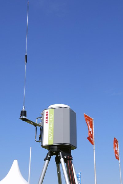
ADCP and topographic measurements in the framework of the DANUBIUS Implementation Phase Project - DANUBIUS-IP – Support Project – Contract No. 116PHE/2025 (PN-IV-P8-8.1-PRE-HE-ORG-2025-0279) – November 2025 – St. George and Sulina mouths. The hydrodynamic datasets were acquired with a powered boat-mounted acoustic Doppler current profiler (ADCP, RiverRay 600 kHz, manufactured by Teledyne Marine) Data collection and processing Software: WinRiver II, Version 2.23.00.01 The Discharge summary files and bathymetry were exported for each cross-section using the equipment software. The topographic datasets were acquired with Trimble R580 GNSS System. The determination of the coordinates (X, Y) and elevations (Z) was done in the Stereographic projection system 1970 (the official Projection System in Romania) with the ETRS 89 datum, and the reference elevation is the Black Sea - Constanța 1975 (the official Altimetric System in Romania).
Related Topics


- Type
- other
- Landing Page
- https://doi.org/10.5281/zenodo.17711325
- OA Status
- green
- OpenAlex ID
- https://openalex.org/W7106715558
Raw OpenAlex JSON
- OpenAlex ID
-
https://openalex.org/W7106715558Canonical identifier for this work in OpenAlex
- DOI
-
https://doi.org/10.5281/zenodo.17711325Digital Object Identifier
- Title
-
ADCP and topographic measurements (C4) in the framework of the DANUBIUS Implementation Phase Project - DANUBIUS-IP – Support Project – Contract No. 116PHE/2025Work title
- Type
-
otherOpenAlex work type
- Publication year
-
2025Year of publication
- Publication date
-
2025-11-25Full publication date if available
- Authors
-
National Institute of Marine Geology and GeoecologyList of authors in order
- Landing page
-
https://doi.org/10.5281/zenodo.17711325Publisher landing page
- Open access
-
YesWhether a free full text is available
- OA status
-
greenOpen access status per OpenAlex
- OA URL
-
https://doi.org/10.5281/zenodo.17711325Direct OA link when available
- Concepts
-
Bathymetry, Stereographic projection, Acoustic Doppler current profiler, Remote sensing, Geology, Global Positioning System, Digital elevation model, GNSS applications, Elevation (ballistics), Geodesy, Altimeter, Projection (relational algebra), Data processing, Phase (matter), Current (fluid), Hydrographic survey, Differential GPS, Georeference, Doppler effect, Structured-light 3D scanner, Orthophoto, Synchronizing, Meteorology, Computer science, Ephemeris, Data collection, SeabedTop concepts (fields/topics) attached by OpenAlex
- Cited by
-
0Total citation count in OpenAlex
Full payload
| id | https://openalex.org/W7106715558 |
|---|---|
| doi | https://doi.org/10.5281/zenodo.17711325 |
| ids.openalex | https://openalex.org/W7106715558 |
| fwci | |
| type | other |
| title | ADCP and topographic measurements (C4) in the framework of the DANUBIUS Implementation Phase Project - DANUBIUS-IP – Support Project – Contract No. 116PHE/2025 |
| biblio.issue | |
| biblio.volume | |
| biblio.last_page | |
| biblio.first_page | |
| is_xpac | False |
| apc_list | |
| apc_paid | |
| concepts[0].id | https://openalex.org/C174943157 |
| concepts[0].level | 2 |
| concepts[0].score | 0.7579468488693237 |
| concepts[0].wikidata | https://www.wikidata.org/wiki/Q810826 |
| concepts[0].display_name | Bathymetry |
| concepts[1].id | https://openalex.org/C119001982 |
| concepts[1].level | 2 |
| concepts[1].score | 0.711552083492279 |
| concepts[1].wikidata | https://www.wikidata.org/wiki/Q866099 |
| concepts[1].display_name | Stereographic projection |
| concepts[2].id | https://openalex.org/C2779365185 |
| concepts[2].level | 3 |
| concepts[2].score | 0.6170039176940918 |
| concepts[2].wikidata | https://www.wikidata.org/wiki/Q624383 |
| concepts[2].display_name | Acoustic Doppler current profiler |
| concepts[3].id | https://openalex.org/C62649853 |
| concepts[3].level | 1 |
| concepts[3].score | 0.6110155582427979 |
| concepts[3].wikidata | https://www.wikidata.org/wiki/Q199687 |
| concepts[3].display_name | Remote sensing |
| concepts[4].id | https://openalex.org/C127313418 |
| concepts[4].level | 0 |
| concepts[4].score | 0.608909547328949 |
| concepts[4].wikidata | https://www.wikidata.org/wiki/Q1069 |
| concepts[4].display_name | Geology |
| concepts[5].id | https://openalex.org/C60229501 |
| concepts[5].level | 2 |
| concepts[5].score | 0.5646097660064697 |
| concepts[5].wikidata | https://www.wikidata.org/wiki/Q18822 |
| concepts[5].display_name | Global Positioning System |
| concepts[6].id | https://openalex.org/C181843262 |
| concepts[6].level | 2 |
| concepts[6].score | 0.5313138365745544 |
| concepts[6].wikidata | https://www.wikidata.org/wiki/Q640492 |
| concepts[6].display_name | Digital elevation model |
| concepts[7].id | https://openalex.org/C14279187 |
| concepts[7].level | 3 |
| concepts[7].score | 0.44607460498809814 |
| concepts[7].wikidata | https://www.wikidata.org/wiki/Q5514012 |
| concepts[7].display_name | GNSS applications |
| concepts[8].id | https://openalex.org/C37054046 |
| concepts[8].level | 2 |
| concepts[8].score | 0.41612228751182556 |
| concepts[8].wikidata | https://www.wikidata.org/wiki/Q641888 |
| concepts[8].display_name | Elevation (ballistics) |
| concepts[9].id | https://openalex.org/C13280743 |
| concepts[9].level | 1 |
| concepts[9].score | 0.38970747590065 |
| concepts[9].wikidata | https://www.wikidata.org/wiki/Q131089 |
| concepts[9].display_name | Geodesy |
| concepts[10].id | https://openalex.org/C17534553 |
| concepts[10].level | 2 |
| concepts[10].score | 0.3677434027194977 |
| concepts[10].wikidata | https://www.wikidata.org/wiki/Q216197 |
| concepts[10].display_name | Altimeter |
| concepts[11].id | https://openalex.org/C57493831 |
| concepts[11].level | 2 |
| concepts[11].score | 0.3657478988170624 |
| concepts[11].wikidata | https://www.wikidata.org/wiki/Q3134666 |
| concepts[11].display_name | Projection (relational algebra) |
| concepts[12].id | https://openalex.org/C138827492 |
| concepts[12].level | 2 |
| concepts[12].score | 0.3655032515525818 |
| concepts[12].wikidata | https://www.wikidata.org/wiki/Q6661985 |
| concepts[12].display_name | Data processing |
| concepts[13].id | https://openalex.org/C44280652 |
| concepts[13].level | 2 |
| concepts[13].score | 0.3653164207935333 |
| concepts[13].wikidata | https://www.wikidata.org/wiki/Q104837 |
| concepts[13].display_name | Phase (matter) |
| concepts[14].id | https://openalex.org/C148043351 |
| concepts[14].level | 2 |
| concepts[14].score | 0.3590885102748871 |
| concepts[14].wikidata | https://www.wikidata.org/wiki/Q4456944 |
| concepts[14].display_name | Current (fluid) |
| concepts[15].id | https://openalex.org/C166408148 |
| concepts[15].level | 2 |
| concepts[15].score | 0.3479686379432678 |
| concepts[15].wikidata | https://www.wikidata.org/wiki/Q2495763 |
| concepts[15].display_name | Hydrographic survey |
| concepts[16].id | https://openalex.org/C2777928014 |
| concepts[16].level | 3 |
| concepts[16].score | 0.3432527482509613 |
| concepts[16].wikidata | https://www.wikidata.org/wiki/Q779225 |
| concepts[16].display_name | Differential GPS |
| concepts[17].id | https://openalex.org/C75145180 |
| concepts[17].level | 2 |
| concepts[17].score | 0.3092370629310608 |
| concepts[17].wikidata | https://www.wikidata.org/wiki/Q772007 |
| concepts[17].display_name | Georeference |
| concepts[18].id | https://openalex.org/C142757262 |
| concepts[18].level | 2 |
| concepts[18].score | 0.30304765701293945 |
| concepts[18].wikidata | https://www.wikidata.org/wiki/Q76436 |
| concepts[18].display_name | Doppler effect |
| concepts[19].id | https://openalex.org/C184577583 |
| concepts[19].level | 3 |
| concepts[19].score | 0.29687637090682983 |
| concepts[19].wikidata | https://www.wikidata.org/wiki/Q1485537 |
| concepts[19].display_name | Structured-light 3D scanner |
| concepts[20].id | https://openalex.org/C82789328 |
| concepts[20].level | 2 |
| concepts[20].score | 0.2918829321861267 |
| concepts[20].wikidata | https://www.wikidata.org/wiki/Q922585 |
| concepts[20].display_name | Orthophoto |
| concepts[21].id | https://openalex.org/C162932704 |
| concepts[21].level | 3 |
| concepts[21].score | 0.2853849232196808 |
| concepts[21].wikidata | https://www.wikidata.org/wiki/Q1058791 |
| concepts[21].display_name | Synchronizing |
| concepts[22].id | https://openalex.org/C153294291 |
| concepts[22].level | 1 |
| concepts[22].score | 0.28100961446762085 |
| concepts[22].wikidata | https://www.wikidata.org/wiki/Q25261 |
| concepts[22].display_name | Meteorology |
| concepts[23].id | https://openalex.org/C41008148 |
| concepts[23].level | 0 |
| concepts[23].score | 0.2780291736125946 |
| concepts[23].wikidata | https://www.wikidata.org/wiki/Q21198 |
| concepts[23].display_name | Computer science |
| concepts[24].id | https://openalex.org/C64828349 |
| concepts[24].level | 3 |
| concepts[24].score | 0.2657221257686615 |
| concepts[24].wikidata | https://www.wikidata.org/wiki/Q120200 |
| concepts[24].display_name | Ephemeris |
| concepts[25].id | https://openalex.org/C133462117 |
| concepts[25].level | 2 |
| concepts[25].score | 0.25373005867004395 |
| concepts[25].wikidata | https://www.wikidata.org/wiki/Q4929239 |
| concepts[25].display_name | Data collection |
| concepts[26].id | https://openalex.org/C33613203 |
| concepts[26].level | 2 |
| concepts[26].score | 0.2529596984386444 |
| concepts[26].wikidata | https://www.wikidata.org/wiki/Q468469 |
| concepts[26].display_name | Seabed |
| keywords[0].id | https://openalex.org/keywords/bathymetry |
| keywords[0].score | 0.7579468488693237 |
| keywords[0].display_name | Bathymetry |
| keywords[1].id | https://openalex.org/keywords/stereographic-projection |
| keywords[1].score | 0.711552083492279 |
| keywords[1].display_name | Stereographic projection |
| keywords[2].id | https://openalex.org/keywords/acoustic-doppler-current-profiler |
| keywords[2].score | 0.6170039176940918 |
| keywords[2].display_name | Acoustic Doppler current profiler |
| keywords[3].id | https://openalex.org/keywords/global-positioning-system |
| keywords[3].score | 0.5646097660064697 |
| keywords[3].display_name | Global Positioning System |
| keywords[4].id | https://openalex.org/keywords/digital-elevation-model |
| keywords[4].score | 0.5313138365745544 |
| keywords[4].display_name | Digital elevation model |
| keywords[5].id | https://openalex.org/keywords/gnss-applications |
| keywords[5].score | 0.44607460498809814 |
| keywords[5].display_name | GNSS applications |
| keywords[6].id | https://openalex.org/keywords/elevation |
| keywords[6].score | 0.41612228751182556 |
| keywords[6].display_name | Elevation (ballistics) |
| keywords[7].id | https://openalex.org/keywords/altimeter |
| keywords[7].score | 0.3677434027194977 |
| keywords[7].display_name | Altimeter |
| keywords[8].id | https://openalex.org/keywords/projection |
| keywords[8].score | 0.3657478988170624 |
| keywords[8].display_name | Projection (relational algebra) |
| language | |
| locations[0].id | pmh:oai:zenodo.org:17711325 |
| locations[0].is_oa | True |
| locations[0].source.id | https://openalex.org/S4306400562 |
| locations[0].source.issn | |
| locations[0].source.type | repository |
| locations[0].source.is_oa | True |
| locations[0].source.issn_l | |
| locations[0].source.is_core | False |
| locations[0].source.is_in_doaj | False |
| locations[0].source.display_name | Zenodo (CERN European Organization for Nuclear Research) |
| locations[0].source.host_organization | https://openalex.org/I67311998 |
| locations[0].source.host_organization_name | European Organization for Nuclear Research |
| locations[0].source.host_organization_lineage | https://openalex.org/I67311998 |
| locations[0].license | cc-by |
| locations[0].pdf_url | |
| locations[0].version | submittedVersion |
| locations[0].raw_type | info:eu-repo/semantics/other |
| locations[0].license_id | https://openalex.org/licenses/cc-by |
| locations[0].is_accepted | False |
| locations[0].is_published | False |
| locations[0].raw_source_name | |
| locations[0].landing_page_url | https://doi.org/10.5281/zenodo.17711325 |
| authorships[0].author.id | |
| authorships[0].author.orcid | |
| authorships[0].author.display_name | National Institute of Marine Geology and Geoecology |
| authorships[0].author_position | first |
| authorships[0].raw_author_name | National Institute of Marine Geology and Geoecology |
| authorships[0].is_corresponding | True |
| has_content.pdf | False |
| has_content.grobid_xml | False |
| is_paratext | False |
| open_access.is_oa | True |
| open_access.oa_url | https://doi.org/10.5281/zenodo.17711325 |
| open_access.oa_status | green |
| open_access.any_repository_has_fulltext | False |
| created_date | 2025-11-27T00:00:00 |
| display_name | ADCP and topographic measurements (C4) in the framework of the DANUBIUS Implementation Phase Project - DANUBIUS-IP – Support Project – Contract No. 116PHE/2025 |
| has_fulltext | False |
| is_retracted | False |
| updated_date | 2025-11-28T02:12:24.556248 |
| primary_topic | |
| cited_by_count | 0 |
| locations_count | 1 |
| best_oa_location.id | pmh:oai:zenodo.org:17711325 |
| best_oa_location.is_oa | True |
| best_oa_location.source.id | https://openalex.org/S4306400562 |
| best_oa_location.source.issn | |
| best_oa_location.source.type | repository |
| best_oa_location.source.is_oa | True |
| best_oa_location.source.issn_l | |
| best_oa_location.source.is_core | False |
| best_oa_location.source.is_in_doaj | False |
| best_oa_location.source.display_name | Zenodo (CERN European Organization for Nuclear Research) |
| best_oa_location.source.host_organization | https://openalex.org/I67311998 |
| best_oa_location.source.host_organization_name | European Organization for Nuclear Research |
| best_oa_location.source.host_organization_lineage | https://openalex.org/I67311998 |
| best_oa_location.license | cc-by |
| best_oa_location.pdf_url | |
| best_oa_location.version | submittedVersion |
| best_oa_location.raw_type | info:eu-repo/semantics/other |
| best_oa_location.license_id | https://openalex.org/licenses/cc-by |
| best_oa_location.is_accepted | False |
| best_oa_location.is_published | False |
| best_oa_location.raw_source_name | |
| best_oa_location.landing_page_url | https://doi.org/10.5281/zenodo.17711325 |
| primary_location.id | pmh:oai:zenodo.org:17711325 |
| primary_location.is_oa | True |
| primary_location.source.id | https://openalex.org/S4306400562 |
| primary_location.source.issn | |
| primary_location.source.type | repository |
| primary_location.source.is_oa | True |
| primary_location.source.issn_l | |
| primary_location.source.is_core | False |
| primary_location.source.is_in_doaj | False |
| primary_location.source.display_name | Zenodo (CERN European Organization for Nuclear Research) |
| primary_location.source.host_organization | https://openalex.org/I67311998 |
| primary_location.source.host_organization_name | European Organization for Nuclear Research |
| primary_location.source.host_organization_lineage | https://openalex.org/I67311998 |
| primary_location.license | cc-by |
| primary_location.pdf_url | |
| primary_location.version | submittedVersion |
| primary_location.raw_type | info:eu-repo/semantics/other |
| primary_location.license_id | https://openalex.org/licenses/cc-by |
| primary_location.is_accepted | False |
| primary_location.is_published | False |
| primary_location.raw_source_name | |
| primary_location.landing_page_url | https://doi.org/10.5281/zenodo.17711325 |
| publication_date | 2025-11-25 |
| publication_year | 2025 |
| referenced_works_count | 0 |
| abstract_inverted_index.- | 13, 127 |
| abstract_inverted_index.a | 39 |
| abstract_inverted_index.89 | 117 |
| abstract_inverted_index.Y) | 96 |
| abstract_inverted_index.by | 51 |
| abstract_inverted_index.in | 4, 102, 112, 134 |
| abstract_inverted_index.is | 123 |
| abstract_inverted_index.of | 7, 92 |
| abstract_inverted_index.(X, | 95 |
| abstract_inverted_index.(Z) | 99 |
| abstract_inverted_index.600 | 48 |
| abstract_inverted_index.II, | 60 |
| abstract_inverted_index.No. | 20 |
| abstract_inverted_index.Sea | 126 |
| abstract_inverted_index.St. | 27 |
| abstract_inverted_index.and | 1, 29, 56, 67, 97, 119 |
| abstract_inverted_index.for | 71 |
| abstract_inverted_index.the | 5, 8, 75, 93, 103, 115, 120, 124 |
| abstract_inverted_index.was | 100 |
| abstract_inverted_index.(the | 108, 130 |
| abstract_inverted_index.1970 | 107 |
| abstract_inverted_index.1975 | 129 |
| abstract_inverted_index.2025 | 25 |
| abstract_inverted_index.ETRS | 116 |
| abstract_inverted_index.GNSS | 86 |
| abstract_inverted_index.R580 | 85 |
| abstract_inverted_index.done | 101 |
| abstract_inverted_index.each | 72 |
| abstract_inverted_index.kHz, | 49 |
| abstract_inverted_index.were | 36, 69, 81 |
| abstract_inverted_index.with | 38, 83, 114 |
| abstract_inverted_index.Black | 125 |
| abstract_inverted_index.Phase | 11 |
| abstract_inverted_index.files | 66 |
| abstract_inverted_index.using | 74 |
| abstract_inverted_index.(ADCP, | 46 |
| abstract_inverted_index.George | 28 |
| abstract_inverted_index.Sulina | 30 |
| abstract_inverted_index.System | 111, 133 |
| abstract_inverted_index.datum, | 118 |
| abstract_inverted_index.system | 106 |
| abstract_inverted_index.– | 15, 18, 23, 26 |
| abstract_inverted_index.Doppler | 43 |
| abstract_inverted_index.Project | 12, 17 |
| abstract_inverted_index.Support | 16 |
| abstract_inverted_index.System. | 87 |
| abstract_inverted_index.Trimble | 84 |
| abstract_inverted_index.Version | 61 |
| abstract_inverted_index.current | 44 |
| abstract_inverted_index.powered | 40 |
| abstract_inverted_index.summary | 65 |
| abstract_inverted_index.Contract | 19 |
| abstract_inverted_index.DANUBIUS | 9 |
| abstract_inverted_index.November | 24 |
| abstract_inverted_index.RiverRay | 47 |
| abstract_inverted_index.Romania) | 113 |
| abstract_inverted_index.Teledyne | 52 |
| abstract_inverted_index.WinRiver | 59 |
| abstract_inverted_index.acoustic | 42 |
| abstract_inverted_index.acquired | 37, 82 |
| abstract_inverted_index.datasets | 35, 80 |
| abstract_inverted_index.exported | 70 |
| abstract_inverted_index.official | 109, 131 |
| abstract_inverted_index.profiler | 45 |
| abstract_inverted_index.Discharge | 64 |
| abstract_inverted_index.Software: | 58 |
| abstract_inverted_index.elevation | 122 |
| abstract_inverted_index.equipment | 76 |
| abstract_inverted_index.framework | 6 |
| abstract_inverted_index.reference | 121 |
| abstract_inverted_index.Altimetric | 132 |
| abstract_inverted_index.Constanța | 128 |
| abstract_inverted_index.Projection | 110 |
| abstract_inverted_index.bathymetry | 68 |
| abstract_inverted_index.collection | 55 |
| abstract_inverted_index.elevations | 98 |
| abstract_inverted_index.processing | 57 |
| abstract_inverted_index.projection | 105 |
| abstract_inverted_index.116PHE/2025 | 21 |
| abstract_inverted_index.DANUBIUS-IP | 14 |
| abstract_inverted_index.coordinates | 94 |
| abstract_inverted_index.topographic | 2, 79 |
| abstract_inverted_index.boat-mounted | 41 |
| abstract_inverted_index.hydrodynamic | 34 |
| abstract_inverted_index.manufactured | 50 |
| abstract_inverted_index.measurements | 3 |
| abstract_inverted_index.Stereographic | 104 |
| abstract_inverted_index.cross-section | 73 |
| abstract_inverted_index.determination | 91 |
| abstract_inverted_index.Implementation | 10 |
| abstract_inverted_index.lang="EN">The | 90 |
| abstract_inverted_index.<p><span | 89 |
| abstract_inverted_index.</span></p> | 88 |
| abstract_inverted_index.<p><span>The | 33, 63, 78 |
| abstract_inverted_index.<p><span>ADCP | 0 |
| abstract_inverted_index.<p><span>Data | 54 |
| abstract_inverted_index.Marine)</span></p> | 53 |
| abstract_inverted_index.mouths.</span></p> | 31 |
| abstract_inverted_index.Romania).</span></p> | 135 |
| abstract_inverted_index.software.</span></p> | 77 |
| abstract_inverted_index.2.23.00.01</span></p> | 62 |
| abstract_inverted_index.(PN-IV-P8-8.1-PRE-HE-ORG-2025-0279) | 22 |
| abstract_inverted_index.<p><span> </span></p> | 32 |
| cited_by_percentile_year | |
| countries_distinct_count | 0 |
| institutions_distinct_count | 1 |
| citation_normalized_percentile |