Considerations on regional continuous Sentinel-1 monitoring services over three different regions Article Swipe
 YOU?
·
· 2022
· Open Access
·
· DOI: https://doi.org/10.5194/egusphere-egu22-1327
YOU?
·
· 2022
· Open Access
·
· DOI: https://doi.org/10.5194/egusphere-egu22-1327
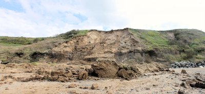
<p>In 2016, a first worldwide continuous monitoring was proposed and implemented over the Tuscany Region (central Italy). It was the first application of SAR (Synthetic Aperture Radar) images for continuous monitoring of on-going ground deformations and, thanks to a PS (Permanent Scatterers) time-series data-mining for identifying changes in the trend, i.e. sudden accelerations or decelerations. The data-mining algorithm was devoted to automatically recognize trend variations higher than a velocity threshold in a determined time span. The continuous monitoring approach benefits from the launch, in 2014, of the Sentinel-1 constellation that allows having a constant flux of images every 12 days (halved to 6 days since 2016 considering the twin satellite at 180° on the same orbit). Two years after Tuscany, in April 2018, the Valle d’Aosta Region, north-western Italy, implemented a similar system to monitor its territory. The challenge was to apply the same approach, with very few changes adopted, in a region with completely different geological and geomorphological features, also considering the snow and glacial covering in winter. In fact, the Tuscany territory is characterized by wide plains, gentle slopes, and mountainous ridges limited to the eastern border in concomitants with the Northern Apennines. Consequently, the ground deformation phenomena in Tuscany are related to active and dormant landslides and subsidence phenomena, mainly due to groundwater extraction and, less commonly, geothermal activity. Valle d’Aosta Region, on the contrary, is almost all characterized by steep slopes with a central close valley. For this reason, the ground deformations to recognize and monitor are almost totally related to landslides, DSGSDs (deep-seated gravitational slope deformation) or rock glaciers. Then, a year later, in July 2019, the continuous monitoring was activated also over the Veneto Region, North-East of Italy. Its territory has partially similar characteristics to Tuscany, in the southern portion, and to the Valle d’Aosta features, in the northern part. Considering the geological and geomorphological properties, the detected ground deformations from Veneto Region share many similarities with the ones from the other two regions. These three laboratories were critically investigated, and after one-year of life, the benefits and the drawbacks of this approach over different environments were highlighted. For all the regions, separately (i) the spatial distribution of the anomalies regions, considering the slope, the aspect, the land cover, and the height, (ii) the persistency of the anomalies along time, (iii) and the correspondence between highlighted moving areas and known inventories, were investigated. At the end, considerations about the benefits evidenced by the use of this approach, considering also the good feedback of the regional administrative personnel, and the required improvements were critically taken into account.</p>
Related Topics


- Type
- preprint
- Language
- en
- Landing Page
- https://doi.org/10.5194/egusphere-egu22-1327
- OA Status
- gold
- Related Works
- 10
- OpenAlex ID
- https://openalex.org/W4220920604
Raw OpenAlex JSON
- OpenAlex ID
-
https://openalex.org/W4220920604Canonical identifier for this work in OpenAlex
- DOI
-
https://doi.org/10.5194/egusphere-egu22-1327Digital Object Identifier
- Title
-
Considerations on regional continuous Sentinel-1 monitoring services over three different regionsWork title
- Type
-
preprintOpenAlex work type
- Language
-
enPrimary language
- Publication year
-
2022Year of publication
- Publication date
-
2022-03-27Full publication date if available
- Authors
-
Matteo Del Soldato, Pierluigi Confuorto, Davide Festa, Silvia Bianchini, Federico RaspiniList of authors in order
- Landing page
-
https://doi.org/10.5194/egusphere-egu22-1327Publisher landing page
- Open access
-
YesWhether a free full text is available
- OA status
-
goldOpen access status per OpenAlex
- OA URL
-
https://doi.org/10.5194/egusphere-egu22-1327Direct OA link when available
- Concepts
-
Geothermal gradient, Subsidence, Geology, Landslide, Continuous monitoring, Groundwater, Geodetic datum, Synthetic aperture radar, Satellite, Geodesy, Seismology, Geography, Remote sensing, Geomorphology, Structural basin, Geophysics, Geotechnical engineering, Engineering, Operations management, Economics, Aerospace engineeringTop concepts (fields/topics) attached by OpenAlex
- Cited by
-
0Total citation count in OpenAlex
- Related works (count)
-
10Other works algorithmically related by OpenAlex
Full payload
| id | https://openalex.org/W4220920604 |
|---|---|
| doi | https://doi.org/10.5194/egusphere-egu22-1327 |
| ids.doi | https://doi.org/10.5194/egusphere-egu22-1327 |
| ids.openalex | https://openalex.org/W4220920604 |
| fwci | 0.0 |
| type | preprint |
| title | Considerations on regional continuous Sentinel-1 monitoring services over three different regions |
| biblio.issue | |
| biblio.volume | |
| biblio.last_page | |
| biblio.first_page | |
| topics[0].id | https://openalex.org/T10535 |
| topics[0].field.id | https://openalex.org/fields/23 |
| topics[0].field.display_name | Environmental Science |
| topics[0].score | 0.9995999932289124 |
| topics[0].domain.id | https://openalex.org/domains/3 |
| topics[0].domain.display_name | Physical Sciences |
| topics[0].subfield.id | https://openalex.org/subfields/2308 |
| topics[0].subfield.display_name | Management, Monitoring, Policy and Law |
| topics[0].display_name | Landslides and related hazards |
| topics[1].id | https://openalex.org/T10644 |
| topics[1].field.id | https://openalex.org/fields/19 |
| topics[1].field.display_name | Earth and Planetary Sciences |
| topics[1].score | 0.9937000274658203 |
| topics[1].domain.id | https://openalex.org/domains/3 |
| topics[1].domain.display_name | Physical Sciences |
| topics[1].subfield.id | https://openalex.org/subfields/1902 |
| topics[1].subfield.display_name | Atmospheric Science |
| topics[1].display_name | Cryospheric studies and observations |
| topics[2].id | https://openalex.org/T10801 |
| topics[2].field.id | https://openalex.org/fields/22 |
| topics[2].field.display_name | Engineering |
| topics[2].score | 0.9769999980926514 |
| topics[2].domain.id | https://openalex.org/domains/3 |
| topics[2].domain.display_name | Physical Sciences |
| topics[2].subfield.id | https://openalex.org/subfields/2202 |
| topics[2].subfield.display_name | Aerospace Engineering |
| topics[2].display_name | Synthetic Aperture Radar (SAR) Applications and Techniques |
| is_xpac | False |
| apc_list | |
| apc_paid | |
| concepts[0].id | https://openalex.org/C111766609 |
| concepts[0].level | 2 |
| concepts[0].score | 0.5754973888397217 |
| concepts[0].wikidata | https://www.wikidata.org/wiki/Q636340 |
| concepts[0].display_name | Geothermal gradient |
| concepts[1].id | https://openalex.org/C180851071 |
| concepts[1].level | 3 |
| concepts[1].score | 0.5551797151565552 |
| concepts[1].wikidata | https://www.wikidata.org/wiki/Q849953 |
| concepts[1].display_name | Subsidence |
| concepts[2].id | https://openalex.org/C127313418 |
| concepts[2].level | 0 |
| concepts[2].score | 0.5411486029624939 |
| concepts[2].wikidata | https://www.wikidata.org/wiki/Q1069 |
| concepts[2].display_name | Geology |
| concepts[3].id | https://openalex.org/C186295008 |
| concepts[3].level | 2 |
| concepts[3].score | 0.503058135509491 |
| concepts[3].wikidata | https://www.wikidata.org/wiki/Q167903 |
| concepts[3].display_name | Landslide |
| concepts[4].id | https://openalex.org/C2776902269 |
| concepts[4].level | 2 |
| concepts[4].score | 0.4912833571434021 |
| concepts[4].wikidata | https://www.wikidata.org/wiki/Q5165493 |
| concepts[4].display_name | Continuous monitoring |
| concepts[5].id | https://openalex.org/C76177295 |
| concepts[5].level | 2 |
| concepts[5].score | 0.49053043127059937 |
| concepts[5].wikidata | https://www.wikidata.org/wiki/Q161598 |
| concepts[5].display_name | Groundwater |
| concepts[6].id | https://openalex.org/C58754882 |
| concepts[6].level | 2 |
| concepts[6].score | 0.47359827160835266 |
| concepts[6].wikidata | https://www.wikidata.org/wiki/Q1502887 |
| concepts[6].display_name | Geodetic datum |
| concepts[7].id | https://openalex.org/C87360688 |
| concepts[7].level | 2 |
| concepts[7].score | 0.457914263010025 |
| concepts[7].wikidata | https://www.wikidata.org/wiki/Q740686 |
| concepts[7].display_name | Synthetic aperture radar |
| concepts[8].id | https://openalex.org/C19269812 |
| concepts[8].level | 2 |
| concepts[8].score | 0.44116273522377014 |
| concepts[8].wikidata | https://www.wikidata.org/wiki/Q26540 |
| concepts[8].display_name | Satellite |
| concepts[9].id | https://openalex.org/C13280743 |
| concepts[9].level | 1 |
| concepts[9].score | 0.3968467712402344 |
| concepts[9].wikidata | https://www.wikidata.org/wiki/Q131089 |
| concepts[9].display_name | Geodesy |
| concepts[10].id | https://openalex.org/C165205528 |
| concepts[10].level | 1 |
| concepts[10].score | 0.36430126428604126 |
| concepts[10].wikidata | https://www.wikidata.org/wiki/Q83371 |
| concepts[10].display_name | Seismology |
| concepts[11].id | https://openalex.org/C205649164 |
| concepts[11].level | 0 |
| concepts[11].score | 0.34645146131515503 |
| concepts[11].wikidata | https://www.wikidata.org/wiki/Q1071 |
| concepts[11].display_name | Geography |
| concepts[12].id | https://openalex.org/C62649853 |
| concepts[12].level | 1 |
| concepts[12].score | 0.3440101146697998 |
| concepts[12].wikidata | https://www.wikidata.org/wiki/Q199687 |
| concepts[12].display_name | Remote sensing |
| concepts[13].id | https://openalex.org/C114793014 |
| concepts[13].level | 1 |
| concepts[13].score | 0.2838519513607025 |
| concepts[13].wikidata | https://www.wikidata.org/wiki/Q52109 |
| concepts[13].display_name | Geomorphology |
| concepts[14].id | https://openalex.org/C109007969 |
| concepts[14].level | 2 |
| concepts[14].score | 0.2142709195613861 |
| concepts[14].wikidata | https://www.wikidata.org/wiki/Q749565 |
| concepts[14].display_name | Structural basin |
| concepts[15].id | https://openalex.org/C8058405 |
| concepts[15].level | 1 |
| concepts[15].score | 0.14750659465789795 |
| concepts[15].wikidata | https://www.wikidata.org/wiki/Q46255 |
| concepts[15].display_name | Geophysics |
| concepts[16].id | https://openalex.org/C187320778 |
| concepts[16].level | 1 |
| concepts[16].score | 0.09972813725471497 |
| concepts[16].wikidata | https://www.wikidata.org/wiki/Q1349130 |
| concepts[16].display_name | Geotechnical engineering |
| concepts[17].id | https://openalex.org/C127413603 |
| concepts[17].level | 0 |
| concepts[17].score | 0.0 |
| concepts[17].wikidata | https://www.wikidata.org/wiki/Q11023 |
| concepts[17].display_name | Engineering |
| concepts[18].id | https://openalex.org/C21547014 |
| concepts[18].level | 1 |
| concepts[18].score | 0.0 |
| concepts[18].wikidata | https://www.wikidata.org/wiki/Q1423657 |
| concepts[18].display_name | Operations management |
| concepts[19].id | https://openalex.org/C162324750 |
| concepts[19].level | 0 |
| concepts[19].score | 0.0 |
| concepts[19].wikidata | https://www.wikidata.org/wiki/Q8134 |
| concepts[19].display_name | Economics |
| concepts[20].id | https://openalex.org/C146978453 |
| concepts[20].level | 1 |
| concepts[20].score | 0.0 |
| concepts[20].wikidata | https://www.wikidata.org/wiki/Q3798668 |
| concepts[20].display_name | Aerospace engineering |
| keywords[0].id | https://openalex.org/keywords/geothermal-gradient |
| keywords[0].score | 0.5754973888397217 |
| keywords[0].display_name | Geothermal gradient |
| keywords[1].id | https://openalex.org/keywords/subsidence |
| keywords[1].score | 0.5551797151565552 |
| keywords[1].display_name | Subsidence |
| keywords[2].id | https://openalex.org/keywords/geology |
| keywords[2].score | 0.5411486029624939 |
| keywords[2].display_name | Geology |
| keywords[3].id | https://openalex.org/keywords/landslide |
| keywords[3].score | 0.503058135509491 |
| keywords[3].display_name | Landslide |
| keywords[4].id | https://openalex.org/keywords/continuous-monitoring |
| keywords[4].score | 0.4912833571434021 |
| keywords[4].display_name | Continuous monitoring |
| keywords[5].id | https://openalex.org/keywords/groundwater |
| keywords[5].score | 0.49053043127059937 |
| keywords[5].display_name | Groundwater |
| keywords[6].id | https://openalex.org/keywords/geodetic-datum |
| keywords[6].score | 0.47359827160835266 |
| keywords[6].display_name | Geodetic datum |
| keywords[7].id | https://openalex.org/keywords/synthetic-aperture-radar |
| keywords[7].score | 0.457914263010025 |
| keywords[7].display_name | Synthetic aperture radar |
| keywords[8].id | https://openalex.org/keywords/satellite |
| keywords[8].score | 0.44116273522377014 |
| keywords[8].display_name | Satellite |
| keywords[9].id | https://openalex.org/keywords/geodesy |
| keywords[9].score | 0.3968467712402344 |
| keywords[9].display_name | Geodesy |
| keywords[10].id | https://openalex.org/keywords/seismology |
| keywords[10].score | 0.36430126428604126 |
| keywords[10].display_name | Seismology |
| keywords[11].id | https://openalex.org/keywords/geography |
| keywords[11].score | 0.34645146131515503 |
| keywords[11].display_name | Geography |
| keywords[12].id | https://openalex.org/keywords/remote-sensing |
| keywords[12].score | 0.3440101146697998 |
| keywords[12].display_name | Remote sensing |
| keywords[13].id | https://openalex.org/keywords/geomorphology |
| keywords[13].score | 0.2838519513607025 |
| keywords[13].display_name | Geomorphology |
| keywords[14].id | https://openalex.org/keywords/structural-basin |
| keywords[14].score | 0.2142709195613861 |
| keywords[14].display_name | Structural basin |
| keywords[15].id | https://openalex.org/keywords/geophysics |
| keywords[15].score | 0.14750659465789795 |
| keywords[15].display_name | Geophysics |
| keywords[16].id | https://openalex.org/keywords/geotechnical-engineering |
| keywords[16].score | 0.09972813725471497 |
| keywords[16].display_name | Geotechnical engineering |
| language | en |
| locations[0].id | doi:10.5194/egusphere-egu22-1327 |
| locations[0].is_oa | True |
| locations[0].source | |
| locations[0].license | cc-by |
| locations[0].pdf_url | |
| locations[0].version | acceptedVersion |
| locations[0].raw_type | posted-content |
| locations[0].license_id | https://openalex.org/licenses/cc-by |
| locations[0].is_accepted | True |
| locations[0].is_published | False |
| locations[0].raw_source_name | |
| locations[0].landing_page_url | https://doi.org/10.5194/egusphere-egu22-1327 |
| indexed_in | crossref |
| authorships[0].author.id | https://openalex.org/A5033431329 |
| authorships[0].author.orcid | https://orcid.org/0000-0001-7539-5850 |
| authorships[0].author.display_name | Matteo Del Soldato |
| authorships[0].countries | IT |
| authorships[0].affiliations[0].institution_ids | https://openalex.org/I45084792 |
| authorships[0].affiliations[0].raw_affiliation_string | University of Firenze, Earth Science Department, Firenze, Italy |
| authorships[0].institutions[0].id | https://openalex.org/I45084792 |
| authorships[0].institutions[0].ror | https://ror.org/04jr1s763 |
| authorships[0].institutions[0].type | education |
| authorships[0].institutions[0].lineage | https://openalex.org/I45084792 |
| authorships[0].institutions[0].country_code | IT |
| authorships[0].institutions[0].display_name | University of Florence |
| authorships[0].author_position | first |
| authorships[0].raw_author_name | Matteo Del Soldato |
| authorships[0].is_corresponding | True |
| authorships[0].raw_affiliation_strings | University of Firenze, Earth Science Department, Firenze, Italy |
| authorships[1].author.id | https://openalex.org/A5009002995 |
| authorships[1].author.orcid | https://orcid.org/0000-0003-4291-4604 |
| authorships[1].author.display_name | Pierluigi Confuorto |
| authorships[1].countries | IT |
| authorships[1].affiliations[0].institution_ids | https://openalex.org/I45084792 |
| authorships[1].affiliations[0].raw_affiliation_string | University of Firenze, Earth Science Department, Firenze, Italy |
| authorships[1].institutions[0].id | https://openalex.org/I45084792 |
| authorships[1].institutions[0].ror | https://ror.org/04jr1s763 |
| authorships[1].institutions[0].type | education |
| authorships[1].institutions[0].lineage | https://openalex.org/I45084792 |
| authorships[1].institutions[0].country_code | IT |
| authorships[1].institutions[0].display_name | University of Florence |
| authorships[1].author_position | middle |
| authorships[1].raw_author_name | Pierluigi Confuorto |
| authorships[1].is_corresponding | True |
| authorships[1].raw_affiliation_strings | University of Firenze, Earth Science Department, Firenze, Italy |
| authorships[2].author.id | https://openalex.org/A5020774979 |
| authorships[2].author.orcid | https://orcid.org/0000-0001-8398-863X |
| authorships[2].author.display_name | Davide Festa |
| authorships[2].countries | IT |
| authorships[2].affiliations[0].institution_ids | https://openalex.org/I45084792 |
| authorships[2].affiliations[0].raw_affiliation_string | University of Firenze, Earth Science Department, Firenze, Italy |
| authorships[2].institutions[0].id | https://openalex.org/I45084792 |
| authorships[2].institutions[0].ror | https://ror.org/04jr1s763 |
| authorships[2].institutions[0].type | education |
| authorships[2].institutions[0].lineage | https://openalex.org/I45084792 |
| authorships[2].institutions[0].country_code | IT |
| authorships[2].institutions[0].display_name | University of Florence |
| authorships[2].author_position | middle |
| authorships[2].raw_author_name | Davide Festa |
| authorships[2].is_corresponding | False |
| authorships[2].raw_affiliation_strings | University of Firenze, Earth Science Department, Firenze, Italy |
| authorships[3].author.id | https://openalex.org/A5048233148 |
| authorships[3].author.orcid | https://orcid.org/0000-0003-2724-5641 |
| authorships[3].author.display_name | Silvia Bianchini |
| authorships[3].countries | IT |
| authorships[3].affiliations[0].institution_ids | https://openalex.org/I45084792 |
| authorships[3].affiliations[0].raw_affiliation_string | University of Firenze, Earth Science Department, Firenze, Italy |
| authorships[3].institutions[0].id | https://openalex.org/I45084792 |
| authorships[3].institutions[0].ror | https://ror.org/04jr1s763 |
| authorships[3].institutions[0].type | education |
| authorships[3].institutions[0].lineage | https://openalex.org/I45084792 |
| authorships[3].institutions[0].country_code | IT |
| authorships[3].institutions[0].display_name | University of Florence |
| authorships[3].author_position | middle |
| authorships[3].raw_author_name | Silvia Bianchini |
| authorships[3].is_corresponding | True |
| authorships[3].raw_affiliation_strings | University of Firenze, Earth Science Department, Firenze, Italy |
| authorships[4].author.id | https://openalex.org/A5034046477 |
| authorships[4].author.orcid | https://orcid.org/0000-0003-0516-164X |
| authorships[4].author.display_name | Federico Raspini |
| authorships[4].countries | IT |
| authorships[4].affiliations[0].institution_ids | https://openalex.org/I45084792 |
| authorships[4].affiliations[0].raw_affiliation_string | University of Firenze, Earth Science Department, Firenze, Italy |
| authorships[4].institutions[0].id | https://openalex.org/I45084792 |
| authorships[4].institutions[0].ror | https://ror.org/04jr1s763 |
| authorships[4].institutions[0].type | education |
| authorships[4].institutions[0].lineage | https://openalex.org/I45084792 |
| authorships[4].institutions[0].country_code | IT |
| authorships[4].institutions[0].display_name | University of Florence |
| authorships[4].author_position | last |
| authorships[4].raw_author_name | Federico Raspini |
| authorships[4].is_corresponding | False |
| authorships[4].raw_affiliation_strings | University of Firenze, Earth Science Department, Firenze, Italy |
| has_content.pdf | False |
| has_content.grobid_xml | False |
| is_paratext | False |
| open_access.is_oa | True |
| open_access.oa_url | https://doi.org/10.5194/egusphere-egu22-1327 |
| open_access.oa_status | gold |
| open_access.any_repository_has_fulltext | False |
| created_date | 2025-10-10T00:00:00 |
| display_name | Considerations on regional continuous Sentinel-1 monitoring services over three different regions |
| has_fulltext | False |
| is_retracted | False |
| updated_date | 2025-11-06T03:46:38.306776 |
| primary_topic.id | https://openalex.org/T10535 |
| primary_topic.field.id | https://openalex.org/fields/23 |
| primary_topic.field.display_name | Environmental Science |
| primary_topic.score | 0.9995999932289124 |
| primary_topic.domain.id | https://openalex.org/domains/3 |
| primary_topic.domain.display_name | Physical Sciences |
| primary_topic.subfield.id | https://openalex.org/subfields/2308 |
| primary_topic.subfield.display_name | Management, Monitoring, Policy and Law |
| primary_topic.display_name | Landslides and related hazards |
| related_works | https://openalex.org/W2389676928, https://openalex.org/W3169474304, https://openalex.org/W2369104181, https://openalex.org/W3201652628, https://openalex.org/W4212972401, https://openalex.org/W2389287188, https://openalex.org/W70668483, https://openalex.org/W2885606342, https://openalex.org/W2950100253, https://openalex.org/W3081499580 |
| cited_by_count | 0 |
| locations_count | 1 |
| best_oa_location.id | doi:10.5194/egusphere-egu22-1327 |
| best_oa_location.is_oa | True |
| best_oa_location.source | |
| best_oa_location.license | cc-by |
| best_oa_location.pdf_url | |
| best_oa_location.version | acceptedVersion |
| best_oa_location.raw_type | posted-content |
| best_oa_location.license_id | https://openalex.org/licenses/cc-by |
| best_oa_location.is_accepted | True |
| best_oa_location.is_published | False |
| best_oa_location.raw_source_name | |
| best_oa_location.landing_page_url | https://doi.org/10.5194/egusphere-egu22-1327 |
| primary_location.id | doi:10.5194/egusphere-egu22-1327 |
| primary_location.is_oa | True |
| primary_location.source | |
| primary_location.license | cc-by |
| primary_location.pdf_url | |
| primary_location.version | acceptedVersion |
| primary_location.raw_type | posted-content |
| primary_location.license_id | https://openalex.org/licenses/cc-by |
| primary_location.is_accepted | True |
| primary_location.is_published | False |
| primary_location.raw_source_name | |
| primary_location.landing_page_url | https://doi.org/10.5194/egusphere-egu22-1327 |
| publication_date | 2022-03-27 |
| publication_year | 2022 |
| referenced_works_count | 0 |
| abstract_inverted_index.6 | 102 |
| abstract_inverted_index.a | 2, 38, 67, 71, 92, 130, 151, 236, 265 |
| abstract_inverted_index.12 | 98 |
| abstract_inverted_index.At | 399 |
| abstract_inverted_index.In | 169 |
| abstract_inverted_index.It | 17 |
| abstract_inverted_index.PS | 39 |
| abstract_inverted_index.at | 110 |
| abstract_inverted_index.by | 176, 232, 407 |
| abstract_inverted_index.in | 47, 70, 83, 120, 150, 167, 189, 200, 268, 292, 302 |
| abstract_inverted_index.is | 174, 228 |
| abstract_inverted_index.of | 22, 31, 85, 95, 282, 339, 346, 363, 381, 410, 418 |
| abstract_inverted_index.on | 112, 225 |
| abstract_inverted_index.or | 53, 261 |
| abstract_inverted_index.to | 37, 60, 101, 133, 140, 185, 204, 214, 246, 254, 290, 297 |
| abstract_inverted_index.(i) | 359 |
| abstract_inverted_index.For | 240, 354 |
| abstract_inverted_index.Its | 284 |
| abstract_inverted_index.SAR | 23 |
| abstract_inverted_index.The | 55, 75, 137 |
| abstract_inverted_index.Two | 116 |
| abstract_inverted_index.all | 230, 355 |
| abstract_inverted_index.and | 9, 157, 164, 181, 206, 209, 248, 296, 309, 336, 343, 375, 387, 394, 423 |
| abstract_inverted_index.are | 202, 250 |
| abstract_inverted_index.due | 213 |
| abstract_inverted_index.few | 147 |
| abstract_inverted_index.for | 28, 44 |
| abstract_inverted_index.has | 286 |
| abstract_inverted_index.its | 135 |
| abstract_inverted_index.the | 12, 19, 48, 81, 86, 107, 113, 123, 142, 162, 171, 186, 192, 196, 226, 243, 271, 278, 293, 298, 303, 307, 312, 323, 326, 341, 344, 356, 360, 364, 368, 370, 372, 376, 379, 382, 388, 400, 404, 408, 415, 419, 424 |
| abstract_inverted_index.two | 328 |
| abstract_inverted_index.use | 409 |
| abstract_inverted_index.was | 7, 18, 58, 139, 274 |
| abstract_inverted_index.(ii) | 378 |
| abstract_inverted_index.2016 | 105 |
| abstract_inverted_index.July | 269 |
| abstract_inverted_index.also | 160, 276, 414 |
| abstract_inverted_index.and, | 35, 217 |
| abstract_inverted_index.days | 99, 103 |
| abstract_inverted_index.end, | 401 |
| abstract_inverted_index.flux | 94 |
| abstract_inverted_index.from | 80, 316, 325 |
| abstract_inverted_index.good | 416 |
| abstract_inverted_index.i.e. | 50 |
| abstract_inverted_index.into | 430 |
| abstract_inverted_index.land | 373 |
| abstract_inverted_index.less | 218 |
| abstract_inverted_index.many | 320 |
| abstract_inverted_index.ones | 324 |
| abstract_inverted_index.over | 11, 277, 349 |
| abstract_inverted_index.rock | 262 |
| abstract_inverted_index.same | 114, 143 |
| abstract_inverted_index.snow | 163 |
| abstract_inverted_index.than | 66 |
| abstract_inverted_index.that | 89 |
| abstract_inverted_index.this | 241, 347, 411 |
| abstract_inverted_index.time | 73 |
| abstract_inverted_index.twin | 108 |
| abstract_inverted_index.very | 146 |
| abstract_inverted_index.were | 333, 352, 397, 427 |
| abstract_inverted_index.wide | 177 |
| abstract_inverted_index.with | 145, 153, 191, 235, 322 |
| abstract_inverted_index.year | 266 |
| abstract_inverted_index.(iii) | 386 |
| abstract_inverted_index.2014, | 84 |
| abstract_inverted_index.2016, | 1 |
| abstract_inverted_index.2018, | 122 |
| abstract_inverted_index.2019, | 270 |
| abstract_inverted_index.April | 121 |
| abstract_inverted_index.Then, | 264 |
| abstract_inverted_index.These | 330 |
| abstract_inverted_index.Valle | 124, 222, 299 |
| abstract_inverted_index.about | 403 |
| abstract_inverted_index.after | 118, 337 |
| abstract_inverted_index.along | 384 |
| abstract_inverted_index.apply | 141 |
| abstract_inverted_index.areas | 393 |
| abstract_inverted_index.close | 238 |
| abstract_inverted_index.every | 97 |
| abstract_inverted_index.fact, | 170 |
| abstract_inverted_index.first | 3, 20 |
| abstract_inverted_index.known | 395 |
| abstract_inverted_index.life, | 340 |
| abstract_inverted_index.other | 327 |
| abstract_inverted_index.part. | 305 |
| abstract_inverted_index.share | 319 |
| abstract_inverted_index.since | 104 |
| abstract_inverted_index.slope | 259 |
| abstract_inverted_index.span. | 74 |
| abstract_inverted_index.steep | 233 |
| abstract_inverted_index.taken | 429 |
| abstract_inverted_index.three | 331 |
| abstract_inverted_index.time, | 385 |
| abstract_inverted_index.trend | 63 |
| abstract_inverted_index.years | 117 |
| abstract_inverted_index.DSGSDs | 256 |
| abstract_inverted_index.Italy, | 128 |
| abstract_inverted_index.Italy. | 283 |
| abstract_inverted_index.Radar) | 26 |
| abstract_inverted_index.Region | 14, 318 |
| abstract_inverted_index.Veneto | 279, 317 |
| abstract_inverted_index.active | 205 |
| abstract_inverted_index.allows | 90 |
| abstract_inverted_index.almost | 229, 251 |
| abstract_inverted_index.border | 188 |
| abstract_inverted_index.cover, | 374 |
| abstract_inverted_index.gentle | 179 |
| abstract_inverted_index.ground | 33, 197, 244, 314 |
| abstract_inverted_index.having | 91 |
| abstract_inverted_index.higher | 65 |
| abstract_inverted_index.images | 27, 96 |
| abstract_inverted_index.later, | 267 |
| abstract_inverted_index.mainly | 212 |
| abstract_inverted_index.moving | 392 |
| abstract_inverted_index.region | 152 |
| abstract_inverted_index.ridges | 183 |
| abstract_inverted_index.slope, | 369 |
| abstract_inverted_index.slopes | 234 |
| abstract_inverted_index.sudden | 51 |
| abstract_inverted_index.system | 132 |
| abstract_inverted_index.thanks | 36 |
| abstract_inverted_index.trend, | 49 |
| abstract_inverted_index.(halved | 100 |
| abstract_inverted_index.Italy). | 16 |
| abstract_inverted_index.Region, | 126, 224, 280 |
| abstract_inverted_index.Tuscany | 13, 172, 201 |
| abstract_inverted_index.aspect, | 371 |
| abstract_inverted_index.between | 390 |
| abstract_inverted_index.central | 237 |
| abstract_inverted_index.changes | 46, 148 |
| abstract_inverted_index.devoted | 59 |
| abstract_inverted_index.dormant | 207 |
| abstract_inverted_index.eastern | 187 |
| abstract_inverted_index.glacial | 165 |
| abstract_inverted_index.height, | 377 |
| abstract_inverted_index.launch, | 82 |
| abstract_inverted_index.limited | 184 |
| abstract_inverted_index.monitor | 134, 249 |
| abstract_inverted_index.orbit). | 115 |
| abstract_inverted_index.plains, | 178 |
| abstract_inverted_index.reason, | 242 |
| abstract_inverted_index.related | 203, 253 |
| abstract_inverted_index.similar | 131, 288 |
| abstract_inverted_index.slopes, | 180 |
| abstract_inverted_index.spatial | 361 |
| abstract_inverted_index.totally | 252 |
| abstract_inverted_index.valley. | 239 |
| abstract_inverted_index.winter. | 168 |
| abstract_inverted_index.(central | 15 |
| abstract_inverted_index.Aperture | 25 |
| abstract_inverted_index.Northern | 193 |
| abstract_inverted_index.Tuscany, | 119, 291 |
| abstract_inverted_index.adopted, | 149 |
| abstract_inverted_index.approach | 78, 348 |
| abstract_inverted_index.benefits | 79, 342, 405 |
| abstract_inverted_index.constant | 93 |
| abstract_inverted_index.covering | 166 |
| abstract_inverted_index.detected | 313 |
| abstract_inverted_index.feedback | 417 |
| abstract_inverted_index.northern | 304 |
| abstract_inverted_index.on-going | 32 |
| abstract_inverted_index.one-year | 338 |
| abstract_inverted_index.portion, | 295 |
| abstract_inverted_index.proposed | 8 |
| abstract_inverted_index.regional | 420 |
| abstract_inverted_index.regions, | 357, 366 |
| abstract_inverted_index.regions. | 329 |
| abstract_inverted_index.required | 425 |
| abstract_inverted_index.southern | 294 |
| abstract_inverted_index.velocity | 68 |
| abstract_inverted_index.activated | 275 |
| abstract_inverted_index.activity. | 221 |
| abstract_inverted_index.algorithm | 57 |
| abstract_inverted_index.anomalies | 365, 383 |
| abstract_inverted_index.approach, | 144, 412 |
| abstract_inverted_index.challenge | 138 |
| abstract_inverted_index.commonly, | 219 |
| abstract_inverted_index.contrary, | 227 |
| abstract_inverted_index.different | 155, 350 |
| abstract_inverted_index.drawbacks | 345 |
| abstract_inverted_index.evidenced | 406 |
| abstract_inverted_index.features, | 159, 301 |
| abstract_inverted_index.glaciers. | 263 |
| abstract_inverted_index.partially | 287 |
| abstract_inverted_index.phenomena | 199 |
| abstract_inverted_index.recognize | 62, 247 |
| abstract_inverted_index.satellite | 109 |
| abstract_inverted_index.territory | 173, 285 |
| abstract_inverted_index.threshold | 69 |
| abstract_inverted_index.worldwide | 4 |
| abstract_inverted_index.(Permanent | 40 |
| abstract_inverted_index.(Synthetic | 24 |
| abstract_inverted_index.Apennines. | 194 |
| abstract_inverted_index.North-East | 281 |
| abstract_inverted_index.Sentinel-1 | 87 |
| abstract_inverted_index.completely | 154 |
| abstract_inverted_index.continuous | 5, 29, 76, 272 |
| abstract_inverted_index.critically | 334, 428 |
| abstract_inverted_index.determined | 72 |
| abstract_inverted_index.extraction | 216 |
| abstract_inverted_index.geological | 156, 308 |
| abstract_inverted_index.geothermal | 220 |
| abstract_inverted_index.landslides | 208 |
| abstract_inverted_index.monitoring | 6, 30, 77, 273 |
| abstract_inverted_index.personnel, | 422 |
| abstract_inverted_index.phenomena, | 211 |
| abstract_inverted_index.separately | 358 |
| abstract_inverted_index.subsidence | 210 |
| abstract_inverted_index.territory. | 136 |
| abstract_inverted_index.variations | 64 |
| abstract_inverted_index.Considering | 306 |
| abstract_inverted_index.Scatterers) | 41 |
| abstract_inverted_index.application | 21 |
| abstract_inverted_index.considering | 106, 161, 367, 413 |
| abstract_inverted_index.data-mining | 43, 56 |
| abstract_inverted_index.deformation | 198 |
| abstract_inverted_index.groundwater | 215 |
| abstract_inverted_index.highlighted | 391 |
| abstract_inverted_index.identifying | 45 |
| abstract_inverted_index.implemented | 10, 129 |
| abstract_inverted_index.landslides, | 255 |
| abstract_inverted_index.mountainous | 182 |
| abstract_inverted_index.persistency | 380 |
| abstract_inverted_index.properties, | 311 |
| abstract_inverted_index.time-series | 42 |
| abstract_inverted_index.(deep-seated | 257 |
| abstract_inverted_index.concomitants | 190 |
| abstract_inverted_index.deformation) | 260 |
| abstract_inverted_index.deformations | 34, 245, 315 |
| abstract_inverted_index.distribution | 362 |
| abstract_inverted_index.environments | 351 |
| abstract_inverted_index.highlighted. | 353 |
| abstract_inverted_index.improvements | 426 |
| abstract_inverted_index.inventories, | 396 |
| abstract_inverted_index.laboratories | 332 |
| abstract_inverted_index.similarities | 321 |
| abstract_inverted_index.Consequently, | 195 |
| abstract_inverted_index.accelerations | 52 |
| abstract_inverted_index.automatically | 61 |
| abstract_inverted_index.characterized | 175, 231 |
| abstract_inverted_index.constellation | 88 |
| abstract_inverted_index.gravitational | 258 |
| abstract_inverted_index.investigated, | 335 |
| abstract_inverted_index.investigated. | 398 |
| abstract_inverted_index.north-western | 127 |
| abstract_inverted_index.administrative | 421 |
| abstract_inverted_index.considerations | 402 |
| abstract_inverted_index.correspondence | 389 |
| abstract_inverted_index.decelerations. | 54 |
| abstract_inverted_index.characteristics | 289 |
| abstract_inverted_index.geomorphological | 158, 310 |
| abstract_inverted_index.180&amp;#176; | 111 |
| abstract_inverted_index.&lt;p&gt;In | 0 |
| abstract_inverted_index.d&amp;#8217;Aosta | 125, 223, 300 |
| abstract_inverted_index.account.&lt;/p&gt; | 431 |
| cited_by_percentile_year | |
| corresponding_author_ids | https://openalex.org/A5033431329, https://openalex.org/A5009002995, https://openalex.org/A5048233148 |
| countries_distinct_count | 1 |
| institutions_distinct_count | 5 |
| corresponding_institution_ids | https://openalex.org/I45084792 |
| citation_normalized_percentile.value | 0.03729999 |
| citation_normalized_percentile.is_in_top_1_percent | False |
| citation_normalized_percentile.is_in_top_10_percent | False |