Coupling Fuzzy logic and Analytical Hierarchy Process (FAHP) with GIS for Landslide Susceptibility Mapping (LSM) in Ziz upper watershed, SE Morocco Article Swipe
 YOU?
·
· 2021
· Open Access
·
· DOI: https://doi.org/10.21203/rs.3.rs-183793/v1
YOU?
·
· 2021
· Open Access
·
· DOI: https://doi.org/10.21203/rs.3.rs-183793/v1
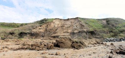
Landslides have become a destructive geo-hazard in many countries, which seriously cause damage to the human lives, infrastructure and properties. They result from the movement of soil on unstable slopes in mountainous areas. This caught attention to study the increasing incidences of landslides in many areas including Morocco. In this study, the fuzzy logic and analytical hierarchy process (FAHP) integrated with the geographic information system (GIS) are used to determinate the landslide susceptibility modeling in the Ziz upper watershed, southeast Morocco. The geo-environmental data that were used in the landslide susceptibility mapping (LSM) included: elevation, lithology, slope, land use/land cover (LULC), river, road, fault, and rainfall maps. FAHP model showed that 16.7% of the study area had high landslide susceptibility. However, the riskiest areas are situated in the upstream western parts. The resultant map of landslides hazards was validated using an inventory of 148 landslides events in the study area. The FAHP model showed a significant performance, the area under curve (AUC) value for this case study is 0.885.
Related Topics


- Type
- preprint
- Language
- en
- Landing Page
- https://doi.org/10.21203/rs.3.rs-183793/v1
- https://www.researchsquare.com/article/rs-183793/v1.pdf?c=1631890894000
- OA Status
- gold
- Cited By
- 6
- References
- 24
- Related Works
- 10
- OpenAlex ID
- https://openalex.org/W3134846267
Raw OpenAlex JSON
- OpenAlex ID
-
https://openalex.org/W3134846267Canonical identifier for this work in OpenAlex
- DOI
-
https://doi.org/10.21203/rs.3.rs-183793/v1Digital Object Identifier
- Title
-
Coupling Fuzzy logic and Analytical Hierarchy Process (FAHP) with GIS for Landslide Susceptibility Mapping (LSM) in Ziz upper watershed, SE MoroccoWork title
- Type
-
preprintOpenAlex work type
- Language
-
enPrimary language
- Publication year
-
2021Year of publication
- Publication date
-
2021-02-23Full publication date if available
- Authors
-
Mohamed Manaouch, Mohamed Sadiki, Imad FenjiroList of authors in order
- Landing page
-
https://doi.org/10.21203/rs.3.rs-183793/v1Publisher landing page
- PDF URL
-
https://www.researchsquare.com/article/rs-183793/v1.pdf?c=1631890894000Direct link to full text PDF
- Open access
-
YesWhether a free full text is available
- OA status
-
goldOpen access status per OpenAlex
- OA URL
-
https://www.researchsquare.com/article/rs-183793/v1.pdf?c=1631890894000Direct OA link when available
- Concepts
-
Landslide, Watershed, Geographic information system, Hazard, Lithology, Land cover, Hydrology (agriculture), Elevation (ballistics), Fuzzy logic, Fault (geology), Geology, Environmental science, Land use, Physical geography, Water resource management, Geomorphology, Geography, Civil engineering, Geotechnical engineering, Remote sensing, Engineering, Computer science, Seismology, Chemistry, Structural engineering, Machine learning, Artificial intelligence, Paleontology, Organic chemistryTop concepts (fields/topics) attached by OpenAlex
- Cited by
-
6Total citation count in OpenAlex
- Citations by year (recent)
-
2025: 1, 2024: 1, 2023: 2, 2022: 2Per-year citation counts (last 5 years)
- References (count)
-
24Number of works referenced by this work
- Related works (count)
-
10Other works algorithmically related by OpenAlex
Full payload
| id | https://openalex.org/W3134846267 |
|---|---|
| doi | https://doi.org/10.21203/rs.3.rs-183793/v1 |
| ids.doi | https://doi.org/10.21203/rs.3.rs-183793/v1 |
| ids.mag | 3134846267 |
| ids.openalex | https://openalex.org/W3134846267 |
| fwci | 1.83356658 |
| type | preprint |
| title | Coupling Fuzzy logic and Analytical Hierarchy Process (FAHP) with GIS for Landslide Susceptibility Mapping (LSM) in Ziz upper watershed, SE Morocco |
| biblio.issue | |
| biblio.volume | |
| biblio.last_page | |
| biblio.first_page | |
| topics[0].id | https://openalex.org/T10535 |
| topics[0].field.id | https://openalex.org/fields/23 |
| topics[0].field.display_name | Environmental Science |
| topics[0].score | 0.9991999864578247 |
| topics[0].domain.id | https://openalex.org/domains/3 |
| topics[0].domain.display_name | Physical Sciences |
| topics[0].subfield.id | https://openalex.org/subfields/2308 |
| topics[0].subfield.display_name | Management, Monitoring, Policy and Law |
| topics[0].display_name | Landslides and related hazards |
| topics[1].id | https://openalex.org/T10555 |
| topics[1].field.id | https://openalex.org/fields/23 |
| topics[1].field.display_name | Environmental Science |
| topics[1].score | 0.9488999843597412 |
| topics[1].domain.id | https://openalex.org/domains/3 |
| topics[1].domain.display_name | Physical Sciences |
| topics[1].subfield.id | https://openalex.org/subfields/2306 |
| topics[1].subfield.display_name | Global and Planetary Change |
| topics[1].display_name | Fire effects on ecosystems |
| topics[2].id | https://openalex.org/T10930 |
| topics[2].field.id | https://openalex.org/fields/23 |
| topics[2].field.display_name | Environmental Science |
| topics[2].score | 0.9394999742507935 |
| topics[2].domain.id | https://openalex.org/domains/3 |
| topics[2].domain.display_name | Physical Sciences |
| topics[2].subfield.id | https://openalex.org/subfields/2306 |
| topics[2].subfield.display_name | Global and Planetary Change |
| topics[2].display_name | Flood Risk Assessment and Management |
| is_xpac | False |
| apc_list | |
| apc_paid | |
| concepts[0].id | https://openalex.org/C186295008 |
| concepts[0].level | 2 |
| concepts[0].score | 0.8789559602737427 |
| concepts[0].wikidata | https://www.wikidata.org/wiki/Q167903 |
| concepts[0].display_name | Landslide |
| concepts[1].id | https://openalex.org/C150547873 |
| concepts[1].level | 2 |
| concepts[1].score | 0.7044707536697388 |
| concepts[1].wikidata | https://www.wikidata.org/wiki/Q947851 |
| concepts[1].display_name | Watershed |
| concepts[2].id | https://openalex.org/C41856607 |
| concepts[2].level | 2 |
| concepts[2].score | 0.531243085861206 |
| concepts[2].wikidata | https://www.wikidata.org/wiki/Q483130 |
| concepts[2].display_name | Geographic information system |
| concepts[3].id | https://openalex.org/C49261128 |
| concepts[3].level | 2 |
| concepts[3].score | 0.4958260953426361 |
| concepts[3].wikidata | https://www.wikidata.org/wiki/Q1132455 |
| concepts[3].display_name | Hazard |
| concepts[4].id | https://openalex.org/C122792734 |
| concepts[4].level | 2 |
| concepts[4].score | 0.49575385451316833 |
| concepts[4].wikidata | https://www.wikidata.org/wiki/Q6538759 |
| concepts[4].display_name | Lithology |
| concepts[5].id | https://openalex.org/C2780648208 |
| concepts[5].level | 3 |
| concepts[5].score | 0.4908350110054016 |
| concepts[5].wikidata | https://www.wikidata.org/wiki/Q3001793 |
| concepts[5].display_name | Land cover |
| concepts[6].id | https://openalex.org/C76886044 |
| concepts[6].level | 2 |
| concepts[6].score | 0.46491342782974243 |
| concepts[6].wikidata | https://www.wikidata.org/wiki/Q2883300 |
| concepts[6].display_name | Hydrology (agriculture) |
| concepts[7].id | https://openalex.org/C37054046 |
| concepts[7].level | 2 |
| concepts[7].score | 0.4500853419303894 |
| concepts[7].wikidata | https://www.wikidata.org/wiki/Q641888 |
| concepts[7].display_name | Elevation (ballistics) |
| concepts[8].id | https://openalex.org/C58166 |
| concepts[8].level | 2 |
| concepts[8].score | 0.4428306221961975 |
| concepts[8].wikidata | https://www.wikidata.org/wiki/Q224821 |
| concepts[8].display_name | Fuzzy logic |
| concepts[9].id | https://openalex.org/C175551986 |
| concepts[9].level | 2 |
| concepts[9].score | 0.4411298334598541 |
| concepts[9].wikidata | https://www.wikidata.org/wiki/Q47089 |
| concepts[9].display_name | Fault (geology) |
| concepts[10].id | https://openalex.org/C127313418 |
| concepts[10].level | 0 |
| concepts[10].score | 0.4058745801448822 |
| concepts[10].wikidata | https://www.wikidata.org/wiki/Q1069 |
| concepts[10].display_name | Geology |
| concepts[11].id | https://openalex.org/C39432304 |
| concepts[11].level | 0 |
| concepts[11].score | 0.3389129340648651 |
| concepts[11].wikidata | https://www.wikidata.org/wiki/Q188847 |
| concepts[11].display_name | Environmental science |
| concepts[12].id | https://openalex.org/C4792198 |
| concepts[12].level | 2 |
| concepts[12].score | 0.3335750699043274 |
| concepts[12].wikidata | https://www.wikidata.org/wiki/Q1165944 |
| concepts[12].display_name | Land use |
| concepts[13].id | https://openalex.org/C100970517 |
| concepts[13].level | 1 |
| concepts[13].score | 0.3272136449813843 |
| concepts[13].wikidata | https://www.wikidata.org/wiki/Q52107 |
| concepts[13].display_name | Physical geography |
| concepts[14].id | https://openalex.org/C524765639 |
| concepts[14].level | 1 |
| concepts[14].score | 0.32418733835220337 |
| concepts[14].wikidata | https://www.wikidata.org/wiki/Q1501619 |
| concepts[14].display_name | Water resource management |
| concepts[15].id | https://openalex.org/C114793014 |
| concepts[15].level | 1 |
| concepts[15].score | 0.28239309787750244 |
| concepts[15].wikidata | https://www.wikidata.org/wiki/Q52109 |
| concepts[15].display_name | Geomorphology |
| concepts[16].id | https://openalex.org/C205649164 |
| concepts[16].level | 0 |
| concepts[16].score | 0.27481526136398315 |
| concepts[16].wikidata | https://www.wikidata.org/wiki/Q1071 |
| concepts[16].display_name | Geography |
| concepts[17].id | https://openalex.org/C147176958 |
| concepts[17].level | 1 |
| concepts[17].score | 0.23573598265647888 |
| concepts[17].wikidata | https://www.wikidata.org/wiki/Q77590 |
| concepts[17].display_name | Civil engineering |
| concepts[18].id | https://openalex.org/C187320778 |
| concepts[18].level | 1 |
| concepts[18].score | 0.21239182353019714 |
| concepts[18].wikidata | https://www.wikidata.org/wiki/Q1349130 |
| concepts[18].display_name | Geotechnical engineering |
| concepts[19].id | https://openalex.org/C62649853 |
| concepts[19].level | 1 |
| concepts[19].score | 0.18432563543319702 |
| concepts[19].wikidata | https://www.wikidata.org/wiki/Q199687 |
| concepts[19].display_name | Remote sensing |
| concepts[20].id | https://openalex.org/C127413603 |
| concepts[20].level | 0 |
| concepts[20].score | 0.1082354485988617 |
| concepts[20].wikidata | https://www.wikidata.org/wiki/Q11023 |
| concepts[20].display_name | Engineering |
| concepts[21].id | https://openalex.org/C41008148 |
| concepts[21].level | 0 |
| concepts[21].score | 0.10775184631347656 |
| concepts[21].wikidata | https://www.wikidata.org/wiki/Q21198 |
| concepts[21].display_name | Computer science |
| concepts[22].id | https://openalex.org/C165205528 |
| concepts[22].level | 1 |
| concepts[22].score | 0.1070505678653717 |
| concepts[22].wikidata | https://www.wikidata.org/wiki/Q83371 |
| concepts[22].display_name | Seismology |
| concepts[23].id | https://openalex.org/C185592680 |
| concepts[23].level | 0 |
| concepts[23].score | 0.0 |
| concepts[23].wikidata | https://www.wikidata.org/wiki/Q2329 |
| concepts[23].display_name | Chemistry |
| concepts[24].id | https://openalex.org/C66938386 |
| concepts[24].level | 1 |
| concepts[24].score | 0.0 |
| concepts[24].wikidata | https://www.wikidata.org/wiki/Q633538 |
| concepts[24].display_name | Structural engineering |
| concepts[25].id | https://openalex.org/C119857082 |
| concepts[25].level | 1 |
| concepts[25].score | 0.0 |
| concepts[25].wikidata | https://www.wikidata.org/wiki/Q2539 |
| concepts[25].display_name | Machine learning |
| concepts[26].id | https://openalex.org/C154945302 |
| concepts[26].level | 1 |
| concepts[26].score | 0.0 |
| concepts[26].wikidata | https://www.wikidata.org/wiki/Q11660 |
| concepts[26].display_name | Artificial intelligence |
| concepts[27].id | https://openalex.org/C151730666 |
| concepts[27].level | 1 |
| concepts[27].score | 0.0 |
| concepts[27].wikidata | https://www.wikidata.org/wiki/Q7205 |
| concepts[27].display_name | Paleontology |
| concepts[28].id | https://openalex.org/C178790620 |
| concepts[28].level | 1 |
| concepts[28].score | 0.0 |
| concepts[28].wikidata | https://www.wikidata.org/wiki/Q11351 |
| concepts[28].display_name | Organic chemistry |
| keywords[0].id | https://openalex.org/keywords/landslide |
| keywords[0].score | 0.8789559602737427 |
| keywords[0].display_name | Landslide |
| keywords[1].id | https://openalex.org/keywords/watershed |
| keywords[1].score | 0.7044707536697388 |
| keywords[1].display_name | Watershed |
| keywords[2].id | https://openalex.org/keywords/geographic-information-system |
| keywords[2].score | 0.531243085861206 |
| keywords[2].display_name | Geographic information system |
| keywords[3].id | https://openalex.org/keywords/hazard |
| keywords[3].score | 0.4958260953426361 |
| keywords[3].display_name | Hazard |
| keywords[4].id | https://openalex.org/keywords/lithology |
| keywords[4].score | 0.49575385451316833 |
| keywords[4].display_name | Lithology |
| keywords[5].id | https://openalex.org/keywords/land-cover |
| keywords[5].score | 0.4908350110054016 |
| keywords[5].display_name | Land cover |
| keywords[6].id | https://openalex.org/keywords/hydrology |
| keywords[6].score | 0.46491342782974243 |
| keywords[6].display_name | Hydrology (agriculture) |
| keywords[7].id | https://openalex.org/keywords/elevation |
| keywords[7].score | 0.4500853419303894 |
| keywords[7].display_name | Elevation (ballistics) |
| keywords[8].id | https://openalex.org/keywords/fuzzy-logic |
| keywords[8].score | 0.4428306221961975 |
| keywords[8].display_name | Fuzzy logic |
| keywords[9].id | https://openalex.org/keywords/fault |
| keywords[9].score | 0.4411298334598541 |
| keywords[9].display_name | Fault (geology) |
| keywords[10].id | https://openalex.org/keywords/geology |
| keywords[10].score | 0.4058745801448822 |
| keywords[10].display_name | Geology |
| keywords[11].id | https://openalex.org/keywords/environmental-science |
| keywords[11].score | 0.3389129340648651 |
| keywords[11].display_name | Environmental science |
| keywords[12].id | https://openalex.org/keywords/land-use |
| keywords[12].score | 0.3335750699043274 |
| keywords[12].display_name | Land use |
| keywords[13].id | https://openalex.org/keywords/physical-geography |
| keywords[13].score | 0.3272136449813843 |
| keywords[13].display_name | Physical geography |
| keywords[14].id | https://openalex.org/keywords/water-resource-management |
| keywords[14].score | 0.32418733835220337 |
| keywords[14].display_name | Water resource management |
| keywords[15].id | https://openalex.org/keywords/geomorphology |
| keywords[15].score | 0.28239309787750244 |
| keywords[15].display_name | Geomorphology |
| keywords[16].id | https://openalex.org/keywords/geography |
| keywords[16].score | 0.27481526136398315 |
| keywords[16].display_name | Geography |
| keywords[17].id | https://openalex.org/keywords/civil-engineering |
| keywords[17].score | 0.23573598265647888 |
| keywords[17].display_name | Civil engineering |
| keywords[18].id | https://openalex.org/keywords/geotechnical-engineering |
| keywords[18].score | 0.21239182353019714 |
| keywords[18].display_name | Geotechnical engineering |
| keywords[19].id | https://openalex.org/keywords/remote-sensing |
| keywords[19].score | 0.18432563543319702 |
| keywords[19].display_name | Remote sensing |
| keywords[20].id | https://openalex.org/keywords/engineering |
| keywords[20].score | 0.1082354485988617 |
| keywords[20].display_name | Engineering |
| keywords[21].id | https://openalex.org/keywords/computer-science |
| keywords[21].score | 0.10775184631347656 |
| keywords[21].display_name | Computer science |
| keywords[22].id | https://openalex.org/keywords/seismology |
| keywords[22].score | 0.1070505678653717 |
| keywords[22].display_name | Seismology |
| language | en |
| locations[0].id | doi:10.21203/rs.3.rs-183793/v1 |
| locations[0].is_oa | True |
| locations[0].source | |
| locations[0].license | cc-by |
| locations[0].pdf_url | https://www.researchsquare.com/article/rs-183793/v1.pdf?c=1631890894000 |
| locations[0].version | acceptedVersion |
| locations[0].raw_type | posted-content |
| locations[0].license_id | https://openalex.org/licenses/cc-by |
| locations[0].is_accepted | True |
| locations[0].is_published | False |
| locations[0].raw_source_name | |
| locations[0].landing_page_url | https://doi.org/10.21203/rs.3.rs-183793/v1 |
| indexed_in | crossref |
| authorships[0].author.id | https://openalex.org/A5018113130 |
| authorships[0].author.orcid | https://orcid.org/0000-0002-2362-7098 |
| authorships[0].author.display_name | Mohamed Manaouch |
| authorships[0].countries | MA |
| authorships[0].affiliations[0].institution_ids | https://openalex.org/I3121676899 |
| authorships[0].affiliations[0].raw_affiliation_string | Universite Ibn Tofail Kenitra |
| authorships[0].institutions[0].id | https://openalex.org/I3121676899 |
| authorships[0].institutions[0].ror | https://ror.org/02wj89n04 |
| authorships[0].institutions[0].type | education |
| authorships[0].institutions[0].lineage | https://openalex.org/I3121676899 |
| authorships[0].institutions[0].country_code | MA |
| authorships[0].institutions[0].display_name | Université Ibn-Tofail |
| authorships[0].author_position | first |
| authorships[0].raw_author_name | Mohamed Manaouch |
| authorships[0].is_corresponding | True |
| authorships[0].raw_affiliation_strings | Universite Ibn Tofail Kenitra |
| authorships[1].author.id | https://openalex.org/A5025782848 |
| authorships[1].author.orcid | https://orcid.org/0000-0003-3970-1683 |
| authorships[1].author.display_name | Mohamed Sadiki |
| authorships[1].countries | MA |
| authorships[1].affiliations[0].institution_ids | https://openalex.org/I3121676899 |
| authorships[1].affiliations[0].raw_affiliation_string | Universite Ibn Tofail Kenitra |
| authorships[1].institutions[0].id | https://openalex.org/I3121676899 |
| authorships[1].institutions[0].ror | https://ror.org/02wj89n04 |
| authorships[1].institutions[0].type | education |
| authorships[1].institutions[0].lineage | https://openalex.org/I3121676899 |
| authorships[1].institutions[0].country_code | MA |
| authorships[1].institutions[0].display_name | Université Ibn-Tofail |
| authorships[1].author_position | middle |
| authorships[1].raw_author_name | Sadiki Mohamed |
| authorships[1].is_corresponding | False |
| authorships[1].raw_affiliation_strings | Universite Ibn Tofail Kenitra |
| authorships[2].author.id | https://openalex.org/A5081625976 |
| authorships[2].author.orcid | |
| authorships[2].author.display_name | Imad Fenjiro |
| authorships[2].countries | MA |
| authorships[2].affiliations[0].institution_ids | https://openalex.org/I3121676899 |
| authorships[2].affiliations[0].raw_affiliation_string | Universite Ibn Tofail Kenitra |
| authorships[2].institutions[0].id | https://openalex.org/I3121676899 |
| authorships[2].institutions[0].ror | https://ror.org/02wj89n04 |
| authorships[2].institutions[0].type | education |
| authorships[2].institutions[0].lineage | https://openalex.org/I3121676899 |
| authorships[2].institutions[0].country_code | MA |
| authorships[2].institutions[0].display_name | Université Ibn-Tofail |
| authorships[2].author_position | last |
| authorships[2].raw_author_name | Fenjiro Imad |
| authorships[2].is_corresponding | False |
| authorships[2].raw_affiliation_strings | Universite Ibn Tofail Kenitra |
| has_content.pdf | True |
| has_content.grobid_xml | True |
| is_paratext | False |
| open_access.is_oa | True |
| open_access.oa_url | https://www.researchsquare.com/article/rs-183793/v1.pdf?c=1631890894000 |
| open_access.oa_status | gold |
| open_access.any_repository_has_fulltext | False |
| created_date | 2025-10-10T00:00:00 |
| display_name | Coupling Fuzzy logic and Analytical Hierarchy Process (FAHP) with GIS for Landslide Susceptibility Mapping (LSM) in Ziz upper watershed, SE Morocco |
| has_fulltext | True |
| is_retracted | False |
| updated_date | 2025-11-06T03:46:38.306776 |
| primary_topic.id | https://openalex.org/T10535 |
| primary_topic.field.id | https://openalex.org/fields/23 |
| primary_topic.field.display_name | Environmental Science |
| primary_topic.score | 0.9991999864578247 |
| primary_topic.domain.id | https://openalex.org/domains/3 |
| primary_topic.domain.display_name | Physical Sciences |
| primary_topic.subfield.id | https://openalex.org/subfields/2308 |
| primary_topic.subfield.display_name | Management, Monitoring, Policy and Law |
| primary_topic.display_name | Landslides and related hazards |
| related_works | https://openalex.org/W2389676928, https://openalex.org/W3169474304, https://openalex.org/W2369104181, https://openalex.org/W3201652628, https://openalex.org/W4212972401, https://openalex.org/W2389287188, https://openalex.org/W70668483, https://openalex.org/W2885606342, https://openalex.org/W3106883776, https://openalex.org/W2950100253 |
| cited_by_count | 6 |
| counts_by_year[0].year | 2025 |
| counts_by_year[0].cited_by_count | 1 |
| counts_by_year[1].year | 2024 |
| counts_by_year[1].cited_by_count | 1 |
| counts_by_year[2].year | 2023 |
| counts_by_year[2].cited_by_count | 2 |
| counts_by_year[3].year | 2022 |
| counts_by_year[3].cited_by_count | 2 |
| locations_count | 1 |
| best_oa_location.id | doi:10.21203/rs.3.rs-183793/v1 |
| best_oa_location.is_oa | True |
| best_oa_location.source | |
| best_oa_location.license | cc-by |
| best_oa_location.pdf_url | https://www.researchsquare.com/article/rs-183793/v1.pdf?c=1631890894000 |
| best_oa_location.version | acceptedVersion |
| best_oa_location.raw_type | posted-content |
| best_oa_location.license_id | https://openalex.org/licenses/cc-by |
| best_oa_location.is_accepted | True |
| best_oa_location.is_published | False |
| best_oa_location.raw_source_name | |
| best_oa_location.landing_page_url | https://doi.org/10.21203/rs.3.rs-183793/v1 |
| primary_location.id | doi:10.21203/rs.3.rs-183793/v1 |
| primary_location.is_oa | True |
| primary_location.source | |
| primary_location.license | cc-by |
| primary_location.pdf_url | https://www.researchsquare.com/article/rs-183793/v1.pdf?c=1631890894000 |
| primary_location.version | acceptedVersion |
| primary_location.raw_type | posted-content |
| primary_location.license_id | https://openalex.org/licenses/cc-by |
| primary_location.is_accepted | True |
| primary_location.is_published | False |
| primary_location.raw_source_name | |
| primary_location.landing_page_url | https://doi.org/10.21203/rs.3.rs-183793/v1 |
| publication_date | 2021-02-23 |
| publication_year | 2021 |
| referenced_works | https://openalex.org/W2606983075, https://openalex.org/W3007620435, https://openalex.org/W2999155771, https://openalex.org/W2092448984, https://openalex.org/W3033199004, https://openalex.org/W4206809064, https://openalex.org/W1971095756, https://openalex.org/W2965059688, https://openalex.org/W3115510497, https://openalex.org/W2057039778, https://openalex.org/W2052982604, https://openalex.org/W2564541699, https://openalex.org/W2260458058, https://openalex.org/W2140679062, https://openalex.org/W2046139462, https://openalex.org/W2069930921, https://openalex.org/W1982137558, https://openalex.org/W2126408653, https://openalex.org/W2293107680, https://openalex.org/W2043814505, https://openalex.org/W2042636168, https://openalex.org/W2619793045, https://openalex.org/W2055249898, https://openalex.org/W4252955559 |
| referenced_works_count | 24 |
| abstract_inverted_index.a | 4, 155 |
| abstract_inverted_index.In | 49 |
| abstract_inverted_index.an | 141 |
| abstract_inverted_index.in | 7, 31, 44, 75, 88, 127, 147 |
| abstract_inverted_index.is | 168 |
| abstract_inverted_index.of | 26, 42, 113, 135, 143 |
| abstract_inverted_index.on | 28 |
| abstract_inverted_index.to | 14, 37, 69 |
| abstract_inverted_index.148 | 144 |
| abstract_inverted_index.The | 82, 132, 151 |
| abstract_inverted_index.Ziz | 77 |
| abstract_inverted_index.and | 19, 55, 105 |
| abstract_inverted_index.are | 67, 125 |
| abstract_inverted_index.for | 164 |
| abstract_inverted_index.had | 117 |
| abstract_inverted_index.map | 134 |
| abstract_inverted_index.the | 15, 24, 39, 52, 62, 71, 76, 89, 114, 122, 128, 148, 158 |
| abstract_inverted_index.was | 138 |
| abstract_inverted_index.FAHP | 108, 152 |
| abstract_inverted_index.They | 21 |
| abstract_inverted_index.This | 34 |
| abstract_inverted_index.area | 116, 159 |
| abstract_inverted_index.case | 166 |
| abstract_inverted_index.data | 84 |
| abstract_inverted_index.from | 23 |
| abstract_inverted_index.have | 2 |
| abstract_inverted_index.high | 118 |
| abstract_inverted_index.land | 98 |
| abstract_inverted_index.many | 8, 45 |
| abstract_inverted_index.soil | 27 |
| abstract_inverted_index.that | 85, 111 |
| abstract_inverted_index.this | 50, 165 |
| abstract_inverted_index.used | 68, 87 |
| abstract_inverted_index.were | 86 |
| abstract_inverted_index.with | 61 |
| abstract_inverted_index.(AUC) | 162 |
| abstract_inverted_index.(GIS) | 66 |
| abstract_inverted_index.(LSM) | 93 |
| abstract_inverted_index.16.7% | 112 |
| abstract_inverted_index.area. | 150 |
| abstract_inverted_index.areas | 46, 124 |
| abstract_inverted_index.cause | 12 |
| abstract_inverted_index.cover | 100 |
| abstract_inverted_index.curve | 161 |
| abstract_inverted_index.fuzzy | 53 |
| abstract_inverted_index.human | 16 |
| abstract_inverted_index.logic | 54 |
| abstract_inverted_index.maps. | 107 |
| abstract_inverted_index.model | 109, 153 |
| abstract_inverted_index.road, | 103 |
| abstract_inverted_index.study | 38, 115, 149, 167 |
| abstract_inverted_index.under | 160 |
| abstract_inverted_index.upper | 78 |
| abstract_inverted_index.using | 140 |
| abstract_inverted_index.value | 163 |
| abstract_inverted_index.which | 10 |
| abstract_inverted_index.(FAHP) | 59 |
| abstract_inverted_index.0.885. | 169 |
| abstract_inverted_index.areas. | 33 |
| abstract_inverted_index.become | 3 |
| abstract_inverted_index.caught | 35 |
| abstract_inverted_index.damage | 13 |
| abstract_inverted_index.events | 146 |
| abstract_inverted_index.fault, | 104 |
| abstract_inverted_index.lives, | 17 |
| abstract_inverted_index.parts. | 131 |
| abstract_inverted_index.result | 22 |
| abstract_inverted_index.river, | 102 |
| abstract_inverted_index.showed | 110, 154 |
| abstract_inverted_index.slope, | 97 |
| abstract_inverted_index.slopes | 30 |
| abstract_inverted_index.study, | 51 |
| abstract_inverted_index.system | 65 |
| abstract_inverted_index.(LULC), | 101 |
| abstract_inverted_index.hazards | 137 |
| abstract_inverted_index.mapping | 92 |
| abstract_inverted_index.process | 58 |
| abstract_inverted_index.western | 130 |
| abstract_inverted_index.However, | 121 |
| abstract_inverted_index.Morocco. | 48, 81 |
| abstract_inverted_index.modeling | 74 |
| abstract_inverted_index.movement | 25 |
| abstract_inverted_index.rainfall | 106 |
| abstract_inverted_index.riskiest | 123 |
| abstract_inverted_index.situated | 126 |
| abstract_inverted_index.unstable | 29 |
| abstract_inverted_index.upstream | 129 |
| abstract_inverted_index.use/land | 99 |
| abstract_inverted_index.attention | 36 |
| abstract_inverted_index.hierarchy | 57 |
| abstract_inverted_index.included: | 94 |
| abstract_inverted_index.including | 47 |
| abstract_inverted_index.inventory | 142 |
| abstract_inverted_index.landslide | 72, 90, 119 |
| abstract_inverted_index.resultant | 133 |
| abstract_inverted_index.seriously | 11 |
| abstract_inverted_index.southeast | 80 |
| abstract_inverted_index.validated | 139 |
| abstract_inverted_index.Landslides | 1 |
| abstract_inverted_index.analytical | 56 |
| abstract_inverted_index.countries, | 9 |
| abstract_inverted_index.elevation, | 95 |
| abstract_inverted_index.geo-hazard | 6 |
| abstract_inverted_index.geographic | 63 |
| abstract_inverted_index.incidences | 41 |
| abstract_inverted_index.increasing | 40 |
| abstract_inverted_index.integrated | 60 |
| abstract_inverted_index.landslides | 43, 136, 145 |
| abstract_inverted_index.lithology, | 96 |
| abstract_inverted_index.watershed, | 79 |
| abstract_inverted_index.destructive | 5 |
| abstract_inverted_index.determinate | 70 |
| abstract_inverted_index.information | 64 |
| abstract_inverted_index.mountainous | 32 |
| abstract_inverted_index.properties. | 20 |
| abstract_inverted_index.significant | 156 |
| abstract_inverted_index.performance, | 157 |
| abstract_inverted_index.infrastructure | 18 |
| abstract_inverted_index.susceptibility | 73, 91 |
| abstract_inverted_index.susceptibility. | 120 |
| abstract_inverted_index.geo-environmental | 83 |
| abstract_inverted_index.<title>Abstract</title> | 0 |
| cited_by_percentile_year.max | 96 |
| cited_by_percentile_year.min | 90 |
| corresponding_author_ids | https://openalex.org/A5018113130 |
| countries_distinct_count | 1 |
| institutions_distinct_count | 3 |
| corresponding_institution_ids | https://openalex.org/I3121676899 |
| citation_normalized_percentile.value | 0.87282908 |
| citation_normalized_percentile.is_in_top_1_percent | False |
| citation_normalized_percentile.is_in_top_10_percent | False |