DIGITAL WORKFLOWS FOR A 3D SEMANTIC REPRESENTATION OF AN ANCIENT MINING LANDSCAPE Article Swipe
 YOU?
·
· 2017
· Open Access
·
· DOI: https://doi.org/10.5194/isprs-archives-xlii-2-w5-355-2017
YOU?
·
· 2017
· Open Access
·
· DOI: https://doi.org/10.5194/isprs-archives-xlii-2-w5-355-2017
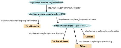
The ancient mining landscape of Schwaz/Brixlegg in the Tyrol, Austria witnessed mining from prehistoric times to modern times creating a first order cultural landscape when it comes to one of the most important inventions in human history: the production of metal. In 1991 a part of this landscape was lost due to an enormous landslide that reshaped part of the mountain. With our work we want to propose a digital workflow to create a 3D semantic representation of this ancient mining landscape with its mining structures to preserve it for posterity. First, we define a conceptual model to integrate the data. It is based on the CIDOC CRM ontology and CRMgeo for geometric data. To transform our information sources to a formal representation of the classes and properties of the ontology we applied semantic web technologies and created a knowledge graph in RDF (Resource Description Framework). Through the CRMgeo extension coordinate information of mining features can be integrated into the RDF graph and thus related to the detailed digital elevation model that may be visualized together with the mining structures using Geoinformation systems or 3D visualization tools. The RDF network of the triple store can be queried using the SPARQL query language. We created a snapshot of mining, settlement and burial sites in the Bronze Age. The results of the query were loaded into a Geoinformation system and a visualization of known bronze age sites related to mining, settlement and burial activities was created.
Related Topics


- Type
- article
- Language
- en
- Landing Page
- https://doi.org/10.5194/isprs-archives-xlii-2-w5-355-2017
- https://www.int-arch-photogramm-remote-sens-spatial-inf-sci.net/XLII-2-W5/355/2017/isprs-archives-XLII-2-W5-355-2017.pdf
- OA Status
- diamond
- Cited By
- 2
- References
- 8
- Related Works
- 10
- OpenAlex ID
- https://openalex.org/W2749172416
Raw OpenAlex JSON
- OpenAlex ID
-
https://openalex.org/W2749172416Canonical identifier for this work in OpenAlex
- DOI
-
https://doi.org/10.5194/isprs-archives-xlii-2-w5-355-2017Digital Object Identifier
- Title
-
DIGITAL WORKFLOWS FOR A 3D SEMANTIC REPRESENTATION OF AN ANCIENT MINING LANDSCAPEWork title
- Type
-
articleOpenAlex work type
- Language
-
enPrimary language
- Publication year
-
2017Year of publication
- Publication date
-
2017-08-18Full publication date if available
- Authors
-
Gerald Hiebel, K. HankeList of authors in order
- Landing page
-
https://doi.org/10.5194/isprs-archives-xlii-2-w5-355-2017Publisher landing page
- PDF URL
-
https://www.int-arch-photogramm-remote-sens-spatial-inf-sci.net/XLII-2-W5/355/2017/isprs-archives-XLII-2-W5-355-2017.pdfDirect link to full text PDF
- Open access
-
YesWhether a free full text is available
- OA status
-
diamondOpen access status per OpenAlex
- OA URL
-
https://www.int-arch-photogramm-remote-sens-spatial-inf-sci.net/XLII-2-W5/355/2017/isprs-archives-XLII-2-W5-355-2017.pdfDirect OA link when available
- Concepts
-
SPARQL, Computer science, RDF, Workflow, Geospatial analysis, Ontology, Geographic information system, Semantic Web, Visualization, Information retrieval, Data science, Archaeology, World Wide Web, Data mining, Geography, Database, Cartography, Philosophy, EpistemologyTop concepts (fields/topics) attached by OpenAlex
- Cited by
-
2Total citation count in OpenAlex
- Citations by year (recent)
-
2019: 1Per-year citation counts (last 5 years)
- References (count)
-
8Number of works referenced by this work
- Related works (count)
-
10Other works algorithmically related by OpenAlex
Full payload
| id | https://openalex.org/W2749172416 |
|---|---|
| doi | https://doi.org/10.5194/isprs-archives-xlii-2-w5-355-2017 |
| ids.doi | https://doi.org/10.5194/isprs-archives-xlii-2-w5-355-2017 |
| ids.mag | 2749172416 |
| ids.openalex | https://openalex.org/W2749172416 |
| fwci | 0.24443685 |
| type | article |
| title | DIGITAL WORKFLOWS FOR A 3D SEMANTIC REPRESENTATION OF AN ANCIENT MINING LANDSCAPE |
| biblio.issue | |
| biblio.volume | XLII-2/W5 |
| biblio.last_page | 359 |
| biblio.first_page | 355 |
| topics[0].id | https://openalex.org/T12698 |
| topics[0].field.id | https://openalex.org/fields/22 |
| topics[0].field.display_name | Engineering |
| topics[0].score | 0.9957000017166138 |
| topics[0].domain.id | https://openalex.org/domains/3 |
| topics[0].domain.display_name | Physical Sciences |
| topics[0].subfield.id | https://openalex.org/subfields/2215 |
| topics[0].subfield.display_name | Building and Construction |
| topics[0].display_name | 3D Modeling in Geospatial Applications |
| topics[1].id | https://openalex.org/T14339 |
| topics[1].field.id | https://openalex.org/fields/17 |
| topics[1].field.display_name | Computer Science |
| topics[1].score | 0.9847999811172485 |
| topics[1].domain.id | https://openalex.org/domains/3 |
| topics[1].domain.display_name | Physical Sciences |
| topics[1].subfield.id | https://openalex.org/subfields/1707 |
| topics[1].subfield.display_name | Computer Vision and Pattern Recognition |
| topics[1].display_name | Image Processing and 3D Reconstruction |
| topics[2].id | https://openalex.org/T10215 |
| topics[2].field.id | https://openalex.org/fields/17 |
| topics[2].field.display_name | Computer Science |
| topics[2].score | 0.9577999711036682 |
| topics[2].domain.id | https://openalex.org/domains/3 |
| topics[2].domain.display_name | Physical Sciences |
| topics[2].subfield.id | https://openalex.org/subfields/1702 |
| topics[2].subfield.display_name | Artificial Intelligence |
| topics[2].display_name | Semantic Web and Ontologies |
| is_xpac | False |
| apc_list | |
| apc_paid | |
| concepts[0].id | https://openalex.org/C41009113 |
| concepts[0].level | 4 |
| concepts[0].score | 0.703559398651123 |
| concepts[0].wikidata | https://www.wikidata.org/wiki/Q54871 |
| concepts[0].display_name | SPARQL |
| concepts[1].id | https://openalex.org/C41008148 |
| concepts[1].level | 0 |
| concepts[1].score | 0.6852906346321106 |
| concepts[1].wikidata | https://www.wikidata.org/wiki/Q21198 |
| concepts[1].display_name | Computer science |
| concepts[2].id | https://openalex.org/C147497476 |
| concepts[2].level | 3 |
| concepts[2].score | 0.6790525317192078 |
| concepts[2].wikidata | https://www.wikidata.org/wiki/Q54872 |
| concepts[2].display_name | RDF |
| concepts[3].id | https://openalex.org/C177212765 |
| concepts[3].level | 2 |
| concepts[3].score | 0.6520038843154907 |
| concepts[3].wikidata | https://www.wikidata.org/wiki/Q627335 |
| concepts[3].display_name | Workflow |
| concepts[4].id | https://openalex.org/C9770341 |
| concepts[4].level | 2 |
| concepts[4].score | 0.5517190098762512 |
| concepts[4].wikidata | https://www.wikidata.org/wiki/Q1938983 |
| concepts[4].display_name | Geospatial analysis |
| concepts[5].id | https://openalex.org/C25810664 |
| concepts[5].level | 2 |
| concepts[5].score | 0.506636917591095 |
| concepts[5].wikidata | https://www.wikidata.org/wiki/Q44325 |
| concepts[5].display_name | Ontology |
| concepts[6].id | https://openalex.org/C41856607 |
| concepts[6].level | 2 |
| concepts[6].score | 0.4750918447971344 |
| concepts[6].wikidata | https://www.wikidata.org/wiki/Q483130 |
| concepts[6].display_name | Geographic information system |
| concepts[7].id | https://openalex.org/C2129575 |
| concepts[7].level | 2 |
| concepts[7].score | 0.4592961370944977 |
| concepts[7].wikidata | https://www.wikidata.org/wiki/Q54837 |
| concepts[7].display_name | Semantic Web |
| concepts[8].id | https://openalex.org/C36464697 |
| concepts[8].level | 2 |
| concepts[8].score | 0.4353945851325989 |
| concepts[8].wikidata | https://www.wikidata.org/wiki/Q451553 |
| concepts[8].display_name | Visualization |
| concepts[9].id | https://openalex.org/C23123220 |
| concepts[9].level | 1 |
| concepts[9].score | 0.4118732511997223 |
| concepts[9].wikidata | https://www.wikidata.org/wiki/Q816826 |
| concepts[9].display_name | Information retrieval |
| concepts[10].id | https://openalex.org/C2522767166 |
| concepts[10].level | 1 |
| concepts[10].score | 0.40972375869750977 |
| concepts[10].wikidata | https://www.wikidata.org/wiki/Q2374463 |
| concepts[10].display_name | Data science |
| concepts[11].id | https://openalex.org/C166957645 |
| concepts[11].level | 1 |
| concepts[11].score | 0.34883207082748413 |
| concepts[11].wikidata | https://www.wikidata.org/wiki/Q23498 |
| concepts[11].display_name | Archaeology |
| concepts[12].id | https://openalex.org/C136764020 |
| concepts[12].level | 1 |
| concepts[12].score | 0.3466060757637024 |
| concepts[12].wikidata | https://www.wikidata.org/wiki/Q466 |
| concepts[12].display_name | World Wide Web |
| concepts[13].id | https://openalex.org/C124101348 |
| concepts[13].level | 1 |
| concepts[13].score | 0.2740517258644104 |
| concepts[13].wikidata | https://www.wikidata.org/wiki/Q172491 |
| concepts[13].display_name | Data mining |
| concepts[14].id | https://openalex.org/C205649164 |
| concepts[14].level | 0 |
| concepts[14].score | 0.26405709981918335 |
| concepts[14].wikidata | https://www.wikidata.org/wiki/Q1071 |
| concepts[14].display_name | Geography |
| concepts[15].id | https://openalex.org/C77088390 |
| concepts[15].level | 1 |
| concepts[15].score | 0.23598456382751465 |
| concepts[15].wikidata | https://www.wikidata.org/wiki/Q8513 |
| concepts[15].display_name | Database |
| concepts[16].id | https://openalex.org/C58640448 |
| concepts[16].level | 1 |
| concepts[16].score | 0.1720578372478485 |
| concepts[16].wikidata | https://www.wikidata.org/wiki/Q42515 |
| concepts[16].display_name | Cartography |
| concepts[17].id | https://openalex.org/C138885662 |
| concepts[17].level | 0 |
| concepts[17].score | 0.0 |
| concepts[17].wikidata | https://www.wikidata.org/wiki/Q5891 |
| concepts[17].display_name | Philosophy |
| concepts[18].id | https://openalex.org/C111472728 |
| concepts[18].level | 1 |
| concepts[18].score | 0.0 |
| concepts[18].wikidata | https://www.wikidata.org/wiki/Q9471 |
| concepts[18].display_name | Epistemology |
| keywords[0].id | https://openalex.org/keywords/sparql |
| keywords[0].score | 0.703559398651123 |
| keywords[0].display_name | SPARQL |
| keywords[1].id | https://openalex.org/keywords/computer-science |
| keywords[1].score | 0.6852906346321106 |
| keywords[1].display_name | Computer science |
| keywords[2].id | https://openalex.org/keywords/rdf |
| keywords[2].score | 0.6790525317192078 |
| keywords[2].display_name | RDF |
| keywords[3].id | https://openalex.org/keywords/workflow |
| keywords[3].score | 0.6520038843154907 |
| keywords[3].display_name | Workflow |
| keywords[4].id | https://openalex.org/keywords/geospatial-analysis |
| keywords[4].score | 0.5517190098762512 |
| keywords[4].display_name | Geospatial analysis |
| keywords[5].id | https://openalex.org/keywords/ontology |
| keywords[5].score | 0.506636917591095 |
| keywords[5].display_name | Ontology |
| keywords[6].id | https://openalex.org/keywords/geographic-information-system |
| keywords[6].score | 0.4750918447971344 |
| keywords[6].display_name | Geographic information system |
| keywords[7].id | https://openalex.org/keywords/semantic-web |
| keywords[7].score | 0.4592961370944977 |
| keywords[7].display_name | Semantic Web |
| keywords[8].id | https://openalex.org/keywords/visualization |
| keywords[8].score | 0.4353945851325989 |
| keywords[8].display_name | Visualization |
| keywords[9].id | https://openalex.org/keywords/information-retrieval |
| keywords[9].score | 0.4118732511997223 |
| keywords[9].display_name | Information retrieval |
| keywords[10].id | https://openalex.org/keywords/data-science |
| keywords[10].score | 0.40972375869750977 |
| keywords[10].display_name | Data science |
| keywords[11].id | https://openalex.org/keywords/archaeology |
| keywords[11].score | 0.34883207082748413 |
| keywords[11].display_name | Archaeology |
| keywords[12].id | https://openalex.org/keywords/world-wide-web |
| keywords[12].score | 0.3466060757637024 |
| keywords[12].display_name | World Wide Web |
| keywords[13].id | https://openalex.org/keywords/data-mining |
| keywords[13].score | 0.2740517258644104 |
| keywords[13].display_name | Data mining |
| keywords[14].id | https://openalex.org/keywords/geography |
| keywords[14].score | 0.26405709981918335 |
| keywords[14].display_name | Geography |
| keywords[15].id | https://openalex.org/keywords/database |
| keywords[15].score | 0.23598456382751465 |
| keywords[15].display_name | Database |
| keywords[16].id | https://openalex.org/keywords/cartography |
| keywords[16].score | 0.1720578372478485 |
| keywords[16].display_name | Cartography |
| language | en |
| locations[0].id | doi:10.5194/isprs-archives-xlii-2-w5-355-2017 |
| locations[0].is_oa | True |
| locations[0].source.id | https://openalex.org/S2737215817 |
| locations[0].source.issn | 1682-1750, 1682-1777, 2194-9034 |
| locations[0].source.type | journal |
| locations[0].source.is_oa | True |
| locations[0].source.issn_l | 1682-1750 |
| locations[0].source.is_core | True |
| locations[0].source.is_in_doaj | True |
| locations[0].source.display_name | The international archives of the photogrammetry, remote sensing and spatial information sciences/International archives of the photogrammetry, remote sensing and spatial information sciences |
| locations[0].source.host_organization | https://openalex.org/P4310313756 |
| locations[0].source.host_organization_name | Copernicus Publications |
| locations[0].source.host_organization_lineage | https://openalex.org/P4310313756 |
| locations[0].source.host_organization_lineage_names | Copernicus Publications |
| locations[0].license | cc-by |
| locations[0].pdf_url | https://www.int-arch-photogramm-remote-sens-spatial-inf-sci.net/XLII-2-W5/355/2017/isprs-archives-XLII-2-W5-355-2017.pdf |
| locations[0].version | publishedVersion |
| locations[0].raw_type | journal-article |
| locations[0].license_id | https://openalex.org/licenses/cc-by |
| locations[0].is_accepted | True |
| locations[0].is_published | True |
| locations[0].raw_source_name | The International Archives of the Photogrammetry, Remote Sensing and Spatial Information Sciences |
| locations[0].landing_page_url | https://doi.org/10.5194/isprs-archives-xlii-2-w5-355-2017 |
| locations[1].id | pmh:oai:doaj.org/article:134cbc141c5e4326b1cb3346fe43ee80 |
| locations[1].is_oa | False |
| locations[1].source.id | https://openalex.org/S4306401280 |
| locations[1].source.issn | |
| locations[1].source.type | repository |
| locations[1].source.is_oa | False |
| locations[1].source.issn_l | |
| locations[1].source.is_core | False |
| locations[1].source.is_in_doaj | False |
| locations[1].source.display_name | DOAJ (DOAJ: Directory of Open Access Journals) |
| locations[1].source.host_organization | |
| locations[1].source.host_organization_name | |
| locations[1].license | |
| locations[1].pdf_url | |
| locations[1].version | submittedVersion |
| locations[1].raw_type | article |
| locations[1].license_id | |
| locations[1].is_accepted | False |
| locations[1].is_published | False |
| locations[1].raw_source_name | The International Archives of the Photogrammetry, Remote Sensing and Spatial Information Sciences, Vol XLII-2-W5, Pp 355-359 (2017) |
| locations[1].landing_page_url | https://doaj.org/article/134cbc141c5e4326b1cb3346fe43ee80 |
| indexed_in | crossref, doaj |
| authorships[0].author.id | https://openalex.org/A5068361127 |
| authorships[0].author.orcid | https://orcid.org/0000-0002-3799-8391 |
| authorships[0].author.display_name | Gerald Hiebel |
| authorships[0].countries | AT |
| authorships[0].affiliations[0].institution_ids | https://openalex.org/I190249584 |
| authorships[0].affiliations[0].raw_affiliation_string | University of Innsbruck, Surveying and Geoinformation Unit, Innsbruck, Austria |
| authorships[0].institutions[0].id | https://openalex.org/I190249584 |
| authorships[0].institutions[0].ror | https://ror.org/054pv6659 |
| authorships[0].institutions[0].type | education |
| authorships[0].institutions[0].lineage | https://openalex.org/I190249584 |
| authorships[0].institutions[0].country_code | AT |
| authorships[0].institutions[0].display_name | Universität Innsbruck |
| authorships[0].author_position | first |
| authorships[0].raw_author_name | G. Hiebel |
| authorships[0].is_corresponding | False |
| authorships[0].raw_affiliation_strings | University of Innsbruck, Surveying and Geoinformation Unit, Innsbruck, Austria |
| authorships[1].author.id | https://openalex.org/A5010121464 |
| authorships[1].author.orcid | https://orcid.org/0000-0002-3648-0400 |
| authorships[1].author.display_name | K. Hanke |
| authorships[1].countries | AT |
| authorships[1].affiliations[0].institution_ids | https://openalex.org/I190249584 |
| authorships[1].affiliations[0].raw_affiliation_string | University of Innsbruck, Surveying and Geoinformation Unit, Innsbruck, Austria |
| authorships[1].institutions[0].id | https://openalex.org/I190249584 |
| authorships[1].institutions[0].ror | https://ror.org/054pv6659 |
| authorships[1].institutions[0].type | education |
| authorships[1].institutions[0].lineage | https://openalex.org/I190249584 |
| authorships[1].institutions[0].country_code | AT |
| authorships[1].institutions[0].display_name | Universität Innsbruck |
| authorships[1].author_position | last |
| authorships[1].raw_author_name | K. Hanke |
| authorships[1].is_corresponding | False |
| authorships[1].raw_affiliation_strings | University of Innsbruck, Surveying and Geoinformation Unit, Innsbruck, Austria |
| has_content.pdf | True |
| has_content.grobid_xml | True |
| is_paratext | False |
| open_access.is_oa | True |
| open_access.oa_url | https://www.int-arch-photogramm-remote-sens-spatial-inf-sci.net/XLII-2-W5/355/2017/isprs-archives-XLII-2-W5-355-2017.pdf |
| open_access.oa_status | diamond |
| open_access.any_repository_has_fulltext | False |
| created_date | 2025-10-10T00:00:00 |
| display_name | DIGITAL WORKFLOWS FOR A 3D SEMANTIC REPRESENTATION OF AN ANCIENT MINING LANDSCAPE |
| has_fulltext | True |
| is_retracted | False |
| updated_date | 2025-11-06T03:46:38.306776 |
| primary_topic.id | https://openalex.org/T12698 |
| primary_topic.field.id | https://openalex.org/fields/22 |
| primary_topic.field.display_name | Engineering |
| primary_topic.score | 0.9957000017166138 |
| primary_topic.domain.id | https://openalex.org/domains/3 |
| primary_topic.domain.display_name | Physical Sciences |
| primary_topic.subfield.id | https://openalex.org/subfields/2215 |
| primary_topic.subfield.display_name | Building and Construction |
| primary_topic.display_name | 3D Modeling in Geospatial Applications |
| related_works | https://openalex.org/W2615202182, https://openalex.org/W4206665951, https://openalex.org/W2529794967, https://openalex.org/W2904139343, https://openalex.org/W2604011835, https://openalex.org/W2528203718, https://openalex.org/W3139465322, https://openalex.org/W2484233589, https://openalex.org/W4241483715, https://openalex.org/W2768092701 |
| cited_by_count | 2 |
| counts_by_year[0].year | 2019 |
| counts_by_year[0].cited_by_count | 1 |
| locations_count | 2 |
| best_oa_location.id | doi:10.5194/isprs-archives-xlii-2-w5-355-2017 |
| best_oa_location.is_oa | True |
| best_oa_location.source.id | https://openalex.org/S2737215817 |
| best_oa_location.source.issn | 1682-1750, 1682-1777, 2194-9034 |
| best_oa_location.source.type | journal |
| best_oa_location.source.is_oa | True |
| best_oa_location.source.issn_l | 1682-1750 |
| best_oa_location.source.is_core | True |
| best_oa_location.source.is_in_doaj | True |
| best_oa_location.source.display_name | The international archives of the photogrammetry, remote sensing and spatial information sciences/International archives of the photogrammetry, remote sensing and spatial information sciences |
| best_oa_location.source.host_organization | https://openalex.org/P4310313756 |
| best_oa_location.source.host_organization_name | Copernicus Publications |
| best_oa_location.source.host_organization_lineage | https://openalex.org/P4310313756 |
| best_oa_location.source.host_organization_lineage_names | Copernicus Publications |
| best_oa_location.license | cc-by |
| best_oa_location.pdf_url | https://www.int-arch-photogramm-remote-sens-spatial-inf-sci.net/XLII-2-W5/355/2017/isprs-archives-XLII-2-W5-355-2017.pdf |
| best_oa_location.version | publishedVersion |
| best_oa_location.raw_type | journal-article |
| best_oa_location.license_id | https://openalex.org/licenses/cc-by |
| best_oa_location.is_accepted | True |
| best_oa_location.is_published | True |
| best_oa_location.raw_source_name | The International Archives of the Photogrammetry, Remote Sensing and Spatial Information Sciences |
| best_oa_location.landing_page_url | https://doi.org/10.5194/isprs-archives-xlii-2-w5-355-2017 |
| primary_location.id | doi:10.5194/isprs-archives-xlii-2-w5-355-2017 |
| primary_location.is_oa | True |
| primary_location.source.id | https://openalex.org/S2737215817 |
| primary_location.source.issn | 1682-1750, 1682-1777, 2194-9034 |
| primary_location.source.type | journal |
| primary_location.source.is_oa | True |
| primary_location.source.issn_l | 1682-1750 |
| primary_location.source.is_core | True |
| primary_location.source.is_in_doaj | True |
| primary_location.source.display_name | The international archives of the photogrammetry, remote sensing and spatial information sciences/International archives of the photogrammetry, remote sensing and spatial information sciences |
| primary_location.source.host_organization | https://openalex.org/P4310313756 |
| primary_location.source.host_organization_name | Copernicus Publications |
| primary_location.source.host_organization_lineage | https://openalex.org/P4310313756 |
| primary_location.source.host_organization_lineage_names | Copernicus Publications |
| primary_location.license | cc-by |
| primary_location.pdf_url | https://www.int-arch-photogramm-remote-sens-spatial-inf-sci.net/XLII-2-W5/355/2017/isprs-archives-XLII-2-W5-355-2017.pdf |
| primary_location.version | publishedVersion |
| primary_location.raw_type | journal-article |
| primary_location.license_id | https://openalex.org/licenses/cc-by |
| primary_location.is_accepted | True |
| primary_location.is_published | True |
| primary_location.raw_source_name | The International Archives of the Photogrammetry, Remote Sensing and Spatial Information Sciences |
| primary_location.landing_page_url | https://doi.org/10.5194/isprs-archives-xlii-2-w5-355-2017 |
| publication_date | 2017-08-18 |
| publication_year | 2017 |
| referenced_works | https://openalex.org/W6634393084, https://openalex.org/W2509531725, https://openalex.org/W2151429351, https://openalex.org/W2130462352, https://openalex.org/W3117602169, https://openalex.org/W1572630243, https://openalex.org/W2259172389, https://openalex.org/W2486787253 |
| referenced_works_count | 8 |
| abstract_inverted_index.a | 20, 44, 69, 74, 95, 121, 139, 205, 225, 229 |
| abstract_inverted_index.3D | 75, 185 |
| abstract_inverted_index.In | 42 |
| abstract_inverted_index.It | 102 |
| abstract_inverted_index.To | 115 |
| abstract_inverted_index.We | 203 |
| abstract_inverted_index.an | 53 |
| abstract_inverted_index.be | 157, 174, 196 |
| abstract_inverted_index.in | 7, 35, 142, 213 |
| abstract_inverted_index.is | 103 |
| abstract_inverted_index.it | 26, 89 |
| abstract_inverted_index.of | 5, 30, 40, 46, 59, 78, 124, 129, 153, 191, 207, 219, 231 |
| abstract_inverted_index.on | 105 |
| abstract_inverted_index.or | 184 |
| abstract_inverted_index.to | 16, 28, 52, 67, 72, 87, 98, 120, 166, 237 |
| abstract_inverted_index.we | 65, 93, 132 |
| abstract_inverted_index.CRM | 108 |
| abstract_inverted_index.RDF | 143, 161, 189 |
| abstract_inverted_index.The | 1, 188, 217 |
| abstract_inverted_index.age | 234 |
| abstract_inverted_index.and | 110, 127, 137, 163, 210, 228, 240 |
| abstract_inverted_index.can | 156, 195 |
| abstract_inverted_index.due | 51 |
| abstract_inverted_index.for | 90, 112 |
| abstract_inverted_index.its | 84 |
| abstract_inverted_index.may | 173 |
| abstract_inverted_index.one | 29 |
| abstract_inverted_index.our | 63, 117 |
| abstract_inverted_index.the | 8, 31, 38, 60, 100, 106, 125, 130, 148, 160, 167, 178, 192, 199, 214, 220 |
| abstract_inverted_index.was | 49, 243 |
| abstract_inverted_index.web | 135 |
| abstract_inverted_index.1991 | 43 |
| abstract_inverted_index.Age. | 216 |
| abstract_inverted_index.With | 62 |
| abstract_inverted_index.from | 13 |
| abstract_inverted_index.into | 159, 224 |
| abstract_inverted_index.lost | 50 |
| abstract_inverted_index.most | 32 |
| abstract_inverted_index.part | 45, 58 |
| abstract_inverted_index.that | 56, 172 |
| abstract_inverted_index.this | 47, 79 |
| abstract_inverted_index.thus | 164 |
| abstract_inverted_index.want | 66 |
| abstract_inverted_index.were | 222 |
| abstract_inverted_index.when | 25 |
| abstract_inverted_index.with | 83, 177 |
| abstract_inverted_index.work | 64 |
| abstract_inverted_index.CIDOC | 107 |
| abstract_inverted_index.based | 104 |
| abstract_inverted_index.comes | 27 |
| abstract_inverted_index.data. | 101, 114 |
| abstract_inverted_index.first | 21 |
| abstract_inverted_index.graph | 141, 162 |
| abstract_inverted_index.human | 36 |
| abstract_inverted_index.known | 232 |
| abstract_inverted_index.model | 97, 171 |
| abstract_inverted_index.order | 22 |
| abstract_inverted_index.query | 201, 221 |
| abstract_inverted_index.sites | 212, 235 |
| abstract_inverted_index.store | 194 |
| abstract_inverted_index.times | 15, 18 |
| abstract_inverted_index.using | 181, 198 |
| abstract_inverted_index.Bronze | 215 |
| abstract_inverted_index.CRMgeo | 111, 149 |
| abstract_inverted_index.First, | 92 |
| abstract_inverted_index.SPARQL | 200 |
| abstract_inverted_index.Tyrol, | 9 |
| abstract_inverted_index.bronze | 233 |
| abstract_inverted_index.burial | 211, 241 |
| abstract_inverted_index.create | 73 |
| abstract_inverted_index.define | 94 |
| abstract_inverted_index.formal | 122 |
| abstract_inverted_index.loaded | 223 |
| abstract_inverted_index.metal. | 41 |
| abstract_inverted_index.mining | 3, 12, 81, 85, 154, 179 |
| abstract_inverted_index.modern | 17 |
| abstract_inverted_index.system | 227 |
| abstract_inverted_index.tools. | 187 |
| abstract_inverted_index.triple | 193 |
| abstract_inverted_index.Austria | 10 |
| abstract_inverted_index.Through | 147 |
| abstract_inverted_index.ancient | 2, 80 |
| abstract_inverted_index.applied | 133 |
| abstract_inverted_index.classes | 126 |
| abstract_inverted_index.created | 138, 204 |
| abstract_inverted_index.digital | 70, 169 |
| abstract_inverted_index.mining, | 208, 238 |
| abstract_inverted_index.network | 190 |
| abstract_inverted_index.propose | 68 |
| abstract_inverted_index.queried | 197 |
| abstract_inverted_index.related | 165, 236 |
| abstract_inverted_index.results | 218 |
| abstract_inverted_index.sources | 119 |
| abstract_inverted_index.systems | 183 |
| abstract_inverted_index.created. | 244 |
| abstract_inverted_index.creating | 19 |
| abstract_inverted_index.cultural | 23 |
| abstract_inverted_index.detailed | 168 |
| abstract_inverted_index.enormous | 54 |
| abstract_inverted_index.features | 155 |
| abstract_inverted_index.history: | 37 |
| abstract_inverted_index.ontology | 109, 131 |
| abstract_inverted_index.preserve | 88 |
| abstract_inverted_index.reshaped | 57 |
| abstract_inverted_index.semantic | 76, 134 |
| abstract_inverted_index.snapshot | 206 |
| abstract_inverted_index.together | 176 |
| abstract_inverted_index.workflow | 71 |
| abstract_inverted_index.(Resource | 144 |
| abstract_inverted_index.Abstract. | 0 |
| abstract_inverted_index.elevation | 170 |
| abstract_inverted_index.extension | 150 |
| abstract_inverted_index.geometric | 113 |
| abstract_inverted_index.important | 33 |
| abstract_inverted_index.integrate | 99 |
| abstract_inverted_index.knowledge | 140 |
| abstract_inverted_index.landscape | 4, 24, 48, 82 |
| abstract_inverted_index.landslide | 55 |
| abstract_inverted_index.language. | 202 |
| abstract_inverted_index.mountain. | 61 |
| abstract_inverted_index.transform | 116 |
| abstract_inverted_index.witnessed | 11 |
| abstract_inverted_index.activities | 242 |
| abstract_inverted_index.conceptual | 96 |
| abstract_inverted_index.coordinate | 151 |
| abstract_inverted_index.integrated | 158 |
| abstract_inverted_index.inventions | 34 |
| abstract_inverted_index.posterity. | 91 |
| abstract_inverted_index.production | 39 |
| abstract_inverted_index.properties | 128 |
| abstract_inverted_index.settlement | 209, 239 |
| abstract_inverted_index.structures | 86, 180 |
| abstract_inverted_index.visualized | 175 |
| abstract_inverted_index.Description | 145 |
| abstract_inverted_index.Framework). | 146 |
| abstract_inverted_index.information | 118, 152 |
| abstract_inverted_index.prehistoric | 14 |
| abstract_inverted_index.technologies | 136 |
| abstract_inverted_index.visualization | 186, 230 |
| abstract_inverted_index.Geoinformation | 182, 226 |
| abstract_inverted_index.representation | 77, 123 |
| abstract_inverted_index.Schwaz/Brixlegg | 6 |
| cited_by_percentile_year.max | 94 |
| cited_by_percentile_year.min | 90 |
| countries_distinct_count | 1 |
| institutions_distinct_count | 2 |
| citation_normalized_percentile.value | 0.59934532 |
| citation_normalized_percentile.is_in_top_1_percent | False |
| citation_normalized_percentile.is_in_top_10_percent | False |