Landslide Susceptibility Mapping of Chaliyar River Basin by Multivariate Statistical Model Article Swipe
 YOU?
·
· 2023
· Open Access
·
· DOI: https://doi.org/10.9734/jeai/2023/v45i122262
YOU?
·
· 2023
· Open Access
·
· DOI: https://doi.org/10.9734/jeai/2023/v45i122262
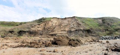
Landslides were frequently observed in nature that can result in significant property damage and fatalities. Land management in landslide-prone areas can be aided by preparing a landslide susceptibility map. The landslide susceptibility of Chaliyar river basin was evaluated using the logistic regression (LR) technique. For this, an inventory map of 592 prior landslides was created using Landsat 8 OLI satellite imagery. The inventory of landslides was then randomly split into 30% and 70% for model training and validation respectively. Fifteen landslide causative factors viz., Slope, Aspect, Curvature, Relative Relief, TWI, Distance to Road, Distance to Streams, Distance to Lineaments, Land Use Land Cover, Drainage Density, Road Density, Lineament Density, Geomorphology, Soil Texture, NDVI were considered for landslide susceptibility modelling. Utilising a Receiver Operating Characteristics Curve (ROC) and Area Under Curve (AUC) value, the resulting susceptibility maps were validated. Analysis reveals that the validation stage of the LR model had a ROC-AUC value of 0.815. The study also demonstrates that slope, soil texture and LULC play a substantial role on the occurrence of landslides in the study area. The proposed landslide susceptibility model is appropriate, taking into account the ROC-AUC (0.815), and can be applied to future land use planning and landslide mitigation in the Chaliyar basin.
Related Topics


- Type
- article
- Language
- en
- Landing Page
- https://doi.org/10.9734/jeai/2023/v45i122262
- https://journaljeai.com/index.php/JEAI/article/download/2262/4520
- OA Status
- diamond
- Cited By
- 3
- References
- 10
- Related Works
- 10
- OpenAlex ID
- https://openalex.org/W4389784885
Raw OpenAlex JSON
- OpenAlex ID
-
https://openalex.org/W4389784885Canonical identifier for this work in OpenAlex
- DOI
-
https://doi.org/10.9734/jeai/2023/v45i122262Digital Object Identifier
- Title
-
Landslide Susceptibility Mapping of Chaliyar River Basin by Multivariate Statistical ModelWork title
- Type
-
articleOpenAlex work type
- Language
-
enPrimary language
- Publication year
-
2023Year of publication
- Publication date
-
2023-12-15Full publication date if available
- Authors
-
L. Aiswarya, K. P. Rema, J. Shyla, V. K. Brijesh, V. VaisakhList of authors in order
- Landing page
-
https://doi.org/10.9734/jeai/2023/v45i122262Publisher landing page
- PDF URL
-
https://journaljeai.com/index.php/JEAI/article/download/2262/4520Direct link to full text PDF
- Open access
-
YesWhether a free full text is available
- OA status
-
diamondOpen access status per OpenAlex
- OA URL
-
https://journaljeai.com/index.php/JEAI/article/download/2262/4520Direct OA link when available
- Concepts
-
Landslide, Lineament, Drainage density, Geology, Land cover, Topographic Wetness Index, Receiver operating characteristic, Drainage basin, Hydrology (agriculture), Normalized Difference Vegetation Index, Geomorphology, Structural basin, Cartography, Land use, Geotechnical engineering, Geography, Statistics, Tectonics, Seismology, Mathematics, Oceanography, Civil engineering, Climate change, EngineeringTop concepts (fields/topics) attached by OpenAlex
- Cited by
-
3Total citation count in OpenAlex
- Citations by year (recent)
-
2025: 2, 2024: 1Per-year citation counts (last 5 years)
- References (count)
-
10Number of works referenced by this work
- Related works (count)
-
10Other works algorithmically related by OpenAlex
Full payload
| id | https://openalex.org/W4389784885 |
|---|---|
| doi | https://doi.org/10.9734/jeai/2023/v45i122262 |
| ids.doi | https://doi.org/10.9734/jeai/2023/v45i122262 |
| ids.openalex | https://openalex.org/W4389784885 |
| fwci | 1.72758911 |
| type | article |
| title | Landslide Susceptibility Mapping of Chaliyar River Basin by Multivariate Statistical Model |
| biblio.issue | 12 |
| biblio.volume | 45 |
| biblio.last_page | 35 |
| biblio.first_page | 23 |
| topics[0].id | https://openalex.org/T10535 |
| topics[0].field.id | https://openalex.org/fields/23 |
| topics[0].field.display_name | Environmental Science |
| topics[0].score | 0.9993000030517578 |
| topics[0].domain.id | https://openalex.org/domains/3 |
| topics[0].domain.display_name | Physical Sciences |
| topics[0].subfield.id | https://openalex.org/subfields/2308 |
| topics[0].subfield.display_name | Management, Monitoring, Policy and Law |
| topics[0].display_name | Landslides and related hazards |
| topics[1].id | https://openalex.org/T12729 |
| topics[1].field.id | https://openalex.org/fields/22 |
| topics[1].field.display_name | Engineering |
| topics[1].score | 0.9585000276565552 |
| topics[1].domain.id | https://openalex.org/domains/3 |
| topics[1].domain.display_name | Physical Sciences |
| topics[1].subfield.id | https://openalex.org/subfields/2210 |
| topics[1].subfield.display_name | Mechanical Engineering |
| topics[1].display_name | Tree Root and Stability Studies |
| topics[2].id | https://openalex.org/T10111 |
| topics[2].field.id | https://openalex.org/fields/23 |
| topics[2].field.display_name | Environmental Science |
| topics[2].score | 0.9577000141143799 |
| topics[2].domain.id | https://openalex.org/domains/3 |
| topics[2].domain.display_name | Physical Sciences |
| topics[2].subfield.id | https://openalex.org/subfields/2303 |
| topics[2].subfield.display_name | Ecology |
| topics[2].display_name | Remote Sensing in Agriculture |
| is_xpac | False |
| apc_list | |
| apc_paid | |
| concepts[0].id | https://openalex.org/C186295008 |
| concepts[0].level | 2 |
| concepts[0].score | 0.8962163925170898 |
| concepts[0].wikidata | https://www.wikidata.org/wiki/Q167903 |
| concepts[0].display_name | Landslide |
| concepts[1].id | https://openalex.org/C92596616 |
| concepts[1].level | 3 |
| concepts[1].score | 0.757314920425415 |
| concepts[1].wikidata | https://www.wikidata.org/wiki/Q1826413 |
| concepts[1].display_name | Lineament |
| concepts[2].id | https://openalex.org/C2779989982 |
| concepts[2].level | 3 |
| concepts[2].score | 0.7070862054824829 |
| concepts[2].wikidata | https://www.wikidata.org/wiki/Q5305552 |
| concepts[2].display_name | Drainage density |
| concepts[3].id | https://openalex.org/C127313418 |
| concepts[3].level | 0 |
| concepts[3].score | 0.5980921387672424 |
| concepts[3].wikidata | https://www.wikidata.org/wiki/Q1069 |
| concepts[3].display_name | Geology |
| concepts[4].id | https://openalex.org/C2780648208 |
| concepts[4].level | 3 |
| concepts[4].score | 0.5777680277824402 |
| concepts[4].wikidata | https://www.wikidata.org/wiki/Q3001793 |
| concepts[4].display_name | Land cover |
| concepts[5].id | https://openalex.org/C2776898743 |
| concepts[5].level | 3 |
| concepts[5].score | 0.5644626021385193 |
| concepts[5].wikidata | https://www.wikidata.org/wiki/Q18353408 |
| concepts[5].display_name | Topographic Wetness Index |
| concepts[6].id | https://openalex.org/C58471807 |
| concepts[6].level | 2 |
| concepts[6].score | 0.5453646779060364 |
| concepts[6].wikidata | https://www.wikidata.org/wiki/Q327120 |
| concepts[6].display_name | Receiver operating characteristic |
| concepts[7].id | https://openalex.org/C126645576 |
| concepts[7].level | 2 |
| concepts[7].score | 0.4862562417984009 |
| concepts[7].wikidata | https://www.wikidata.org/wiki/Q166620 |
| concepts[7].display_name | Drainage basin |
| concepts[8].id | https://openalex.org/C76886044 |
| concepts[8].level | 2 |
| concepts[8].score | 0.4749179780483246 |
| concepts[8].wikidata | https://www.wikidata.org/wiki/Q2883300 |
| concepts[8].display_name | Hydrology (agriculture) |
| concepts[9].id | https://openalex.org/C1549246 |
| concepts[9].level | 3 |
| concepts[9].score | 0.46918439865112305 |
| concepts[9].wikidata | https://www.wikidata.org/wiki/Q718775 |
| concepts[9].display_name | Normalized Difference Vegetation Index |
| concepts[10].id | https://openalex.org/C114793014 |
| concepts[10].level | 1 |
| concepts[10].score | 0.40175682306289673 |
| concepts[10].wikidata | https://www.wikidata.org/wiki/Q52109 |
| concepts[10].display_name | Geomorphology |
| concepts[11].id | https://openalex.org/C109007969 |
| concepts[11].level | 2 |
| concepts[11].score | 0.37889397144317627 |
| concepts[11].wikidata | https://www.wikidata.org/wiki/Q749565 |
| concepts[11].display_name | Structural basin |
| concepts[12].id | https://openalex.org/C58640448 |
| concepts[12].level | 1 |
| concepts[12].score | 0.35505586862564087 |
| concepts[12].wikidata | https://www.wikidata.org/wiki/Q42515 |
| concepts[12].display_name | Cartography |
| concepts[13].id | https://openalex.org/C4792198 |
| concepts[13].level | 2 |
| concepts[13].score | 0.3505561947822571 |
| concepts[13].wikidata | https://www.wikidata.org/wiki/Q1165944 |
| concepts[13].display_name | Land use |
| concepts[14].id | https://openalex.org/C187320778 |
| concepts[14].level | 1 |
| concepts[14].score | 0.19221827387809753 |
| concepts[14].wikidata | https://www.wikidata.org/wiki/Q1349130 |
| concepts[14].display_name | Geotechnical engineering |
| concepts[15].id | https://openalex.org/C205649164 |
| concepts[15].level | 0 |
| concepts[15].score | 0.18615198135375977 |
| concepts[15].wikidata | https://www.wikidata.org/wiki/Q1071 |
| concepts[15].display_name | Geography |
| concepts[16].id | https://openalex.org/C105795698 |
| concepts[16].level | 1 |
| concepts[16].score | 0.1609618067741394 |
| concepts[16].wikidata | https://www.wikidata.org/wiki/Q12483 |
| concepts[16].display_name | Statistics |
| concepts[17].id | https://openalex.org/C77928131 |
| concepts[17].level | 2 |
| concepts[17].score | 0.08629733324050903 |
| concepts[17].wikidata | https://www.wikidata.org/wiki/Q193343 |
| concepts[17].display_name | Tectonics |
| concepts[18].id | https://openalex.org/C165205528 |
| concepts[18].level | 1 |
| concepts[18].score | 0.08118295669555664 |
| concepts[18].wikidata | https://www.wikidata.org/wiki/Q83371 |
| concepts[18].display_name | Seismology |
| concepts[19].id | https://openalex.org/C33923547 |
| concepts[19].level | 0 |
| concepts[19].score | 0.07493188977241516 |
| concepts[19].wikidata | https://www.wikidata.org/wiki/Q395 |
| concepts[19].display_name | Mathematics |
| concepts[20].id | https://openalex.org/C111368507 |
| concepts[20].level | 1 |
| concepts[20].score | 0.0 |
| concepts[20].wikidata | https://www.wikidata.org/wiki/Q43518 |
| concepts[20].display_name | Oceanography |
| concepts[21].id | https://openalex.org/C147176958 |
| concepts[21].level | 1 |
| concepts[21].score | 0.0 |
| concepts[21].wikidata | https://www.wikidata.org/wiki/Q77590 |
| concepts[21].display_name | Civil engineering |
| concepts[22].id | https://openalex.org/C132651083 |
| concepts[22].level | 2 |
| concepts[22].score | 0.0 |
| concepts[22].wikidata | https://www.wikidata.org/wiki/Q7942 |
| concepts[22].display_name | Climate change |
| concepts[23].id | https://openalex.org/C127413603 |
| concepts[23].level | 0 |
| concepts[23].score | 0.0 |
| concepts[23].wikidata | https://www.wikidata.org/wiki/Q11023 |
| concepts[23].display_name | Engineering |
| keywords[0].id | https://openalex.org/keywords/landslide |
| keywords[0].score | 0.8962163925170898 |
| keywords[0].display_name | Landslide |
| keywords[1].id | https://openalex.org/keywords/lineament |
| keywords[1].score | 0.757314920425415 |
| keywords[1].display_name | Lineament |
| keywords[2].id | https://openalex.org/keywords/drainage-density |
| keywords[2].score | 0.7070862054824829 |
| keywords[2].display_name | Drainage density |
| keywords[3].id | https://openalex.org/keywords/geology |
| keywords[3].score | 0.5980921387672424 |
| keywords[3].display_name | Geology |
| keywords[4].id | https://openalex.org/keywords/land-cover |
| keywords[4].score | 0.5777680277824402 |
| keywords[4].display_name | Land cover |
| keywords[5].id | https://openalex.org/keywords/topographic-wetness-index |
| keywords[5].score | 0.5644626021385193 |
| keywords[5].display_name | Topographic Wetness Index |
| keywords[6].id | https://openalex.org/keywords/receiver-operating-characteristic |
| keywords[6].score | 0.5453646779060364 |
| keywords[6].display_name | Receiver operating characteristic |
| keywords[7].id | https://openalex.org/keywords/drainage-basin |
| keywords[7].score | 0.4862562417984009 |
| keywords[7].display_name | Drainage basin |
| keywords[8].id | https://openalex.org/keywords/hydrology |
| keywords[8].score | 0.4749179780483246 |
| keywords[8].display_name | Hydrology (agriculture) |
| keywords[9].id | https://openalex.org/keywords/normalized-difference-vegetation-index |
| keywords[9].score | 0.46918439865112305 |
| keywords[9].display_name | Normalized Difference Vegetation Index |
| keywords[10].id | https://openalex.org/keywords/geomorphology |
| keywords[10].score | 0.40175682306289673 |
| keywords[10].display_name | Geomorphology |
| keywords[11].id | https://openalex.org/keywords/structural-basin |
| keywords[11].score | 0.37889397144317627 |
| keywords[11].display_name | Structural basin |
| keywords[12].id | https://openalex.org/keywords/cartography |
| keywords[12].score | 0.35505586862564087 |
| keywords[12].display_name | Cartography |
| keywords[13].id | https://openalex.org/keywords/land-use |
| keywords[13].score | 0.3505561947822571 |
| keywords[13].display_name | Land use |
| keywords[14].id | https://openalex.org/keywords/geotechnical-engineering |
| keywords[14].score | 0.19221827387809753 |
| keywords[14].display_name | Geotechnical engineering |
| keywords[15].id | https://openalex.org/keywords/geography |
| keywords[15].score | 0.18615198135375977 |
| keywords[15].display_name | Geography |
| keywords[16].id | https://openalex.org/keywords/statistics |
| keywords[16].score | 0.1609618067741394 |
| keywords[16].display_name | Statistics |
| keywords[17].id | https://openalex.org/keywords/tectonics |
| keywords[17].score | 0.08629733324050903 |
| keywords[17].display_name | Tectonics |
| keywords[18].id | https://openalex.org/keywords/seismology |
| keywords[18].score | 0.08118295669555664 |
| keywords[18].display_name | Seismology |
| keywords[19].id | https://openalex.org/keywords/mathematics |
| keywords[19].score | 0.07493188977241516 |
| keywords[19].display_name | Mathematics |
| language | en |
| locations[0].id | doi:10.9734/jeai/2023/v45i122262 |
| locations[0].is_oa | True |
| locations[0].source.id | https://openalex.org/S4210169779 |
| locations[0].source.issn | 2457-0591 |
| locations[0].source.type | journal |
| locations[0].source.is_oa | True |
| locations[0].source.issn_l | 2457-0591 |
| locations[0].source.is_core | False |
| locations[0].source.is_in_doaj | False |
| locations[0].source.display_name | Journal of Experimental Agriculture International |
| locations[0].source.host_organization | https://openalex.org/P4310320855 |
| locations[0].source.host_organization_name | Sciencedomain International |
| locations[0].source.host_organization_lineage | https://openalex.org/P4310320855 |
| locations[0].source.host_organization_lineage_names | Sciencedomain International |
| locations[0].license | |
| locations[0].pdf_url | https://journaljeai.com/index.php/JEAI/article/download/2262/4520 |
| locations[0].version | publishedVersion |
| locations[0].raw_type | journal-article |
| locations[0].license_id | |
| locations[0].is_accepted | True |
| locations[0].is_published | True |
| locations[0].raw_source_name | Journal of Experimental Agriculture International |
| locations[0].landing_page_url | https://doi.org/10.9734/jeai/2023/v45i122262 |
| indexed_in | crossref |
| authorships[0].author.id | https://openalex.org/A5092734265 |
| authorships[0].author.orcid | |
| authorships[0].author.display_name | L. Aiswarya |
| authorships[0].affiliations[0].raw_affiliation_string | Department of IDE, KCAET, Tavanur, India. |
| authorships[0].author_position | first |
| authorships[0].raw_author_name | L. Aiswarya |
| authorships[0].is_corresponding | False |
| authorships[0].raw_affiliation_strings | Department of IDE, KCAET, Tavanur, India. |
| authorships[1].author.id | https://openalex.org/A5077917656 |
| authorships[1].author.orcid | |
| authorships[1].author.display_name | K. P. Rema |
| authorships[1].affiliations[0].raw_affiliation_string | Department of IDE, KCAET, Tavanur, India. |
| authorships[1].author_position | middle |
| authorships[1].raw_author_name | K. P. Rema |
| authorships[1].is_corresponding | False |
| authorships[1].raw_affiliation_strings | Department of IDE, KCAET, Tavanur, India. |
| authorships[2].author.id | https://openalex.org/A5093505452 |
| authorships[2].author.orcid | |
| authorships[2].author.display_name | J. Shyla |
| authorships[2].affiliations[0].raw_affiliation_string | ARS, Chalakudy, India. |
| authorships[2].author_position | middle |
| authorships[2].raw_author_name | J. Shyla |
| authorships[2].is_corresponding | False |
| authorships[2].raw_affiliation_strings | ARS, Chalakudy, India. |
| authorships[3].author.id | https://openalex.org/A5070032562 |
| authorships[3].author.orcid | |
| authorships[3].author.display_name | V. K. Brijesh |
| authorships[3].countries | IN |
| authorships[3].affiliations[0].institution_ids | https://openalex.org/I64389444 |
| authorships[3].affiliations[0].raw_affiliation_string | Department of Geology, MES, Ponnani, India. |
| authorships[3].institutions[0].id | https://openalex.org/I64389444 |
| authorships[3].institutions[0].ror | https://ror.org/00nthx533 |
| authorships[3].institutions[0].type | government |
| authorships[3].institutions[0].lineage | https://openalex.org/I64389444 |
| authorships[3].institutions[0].country_code | IN |
| authorships[3].institutions[0].display_name | Geological Survey of India |
| authorships[3].author_position | middle |
| authorships[3].raw_author_name | V. K. Brijesh |
| authorships[3].is_corresponding | False |
| authorships[3].raw_affiliation_strings | Department of Geology, MES, Ponnani, India. |
| authorships[4].author.id | https://openalex.org/A5093505453 |
| authorships[4].author.orcid | |
| authorships[4].author.display_name | V. Vaisakh |
| authorships[4].affiliations[0].raw_affiliation_string | Department of BEAS, KCAET, Tavanur, India. |
| authorships[4].author_position | last |
| authorships[4].raw_author_name | V. Vaisakh |
| authorships[4].is_corresponding | False |
| authorships[4].raw_affiliation_strings | Department of BEAS, KCAET, Tavanur, India. |
| has_content.pdf | True |
| has_content.grobid_xml | True |
| is_paratext | False |
| open_access.is_oa | True |
| open_access.oa_url | https://journaljeai.com/index.php/JEAI/article/download/2262/4520 |
| open_access.oa_status | diamond |
| open_access.any_repository_has_fulltext | False |
| created_date | 2025-10-10T00:00:00 |
| display_name | Landslide Susceptibility Mapping of Chaliyar River Basin by Multivariate Statistical Model |
| has_fulltext | True |
| is_retracted | False |
| updated_date | 2025-11-06T03:46:38.306776 |
| primary_topic.id | https://openalex.org/T10535 |
| primary_topic.field.id | https://openalex.org/fields/23 |
| primary_topic.field.display_name | Environmental Science |
| primary_topic.score | 0.9993000030517578 |
| primary_topic.domain.id | https://openalex.org/domains/3 |
| primary_topic.domain.display_name | Physical Sciences |
| primary_topic.subfield.id | https://openalex.org/subfields/2308 |
| primary_topic.subfield.display_name | Management, Monitoring, Policy and Law |
| primary_topic.display_name | Landslides and related hazards |
| related_works | https://openalex.org/W2021379394, https://openalex.org/W3217579583, https://openalex.org/W2752042831, https://openalex.org/W1977328418, https://openalex.org/W1192997862, https://openalex.org/W3215334365, https://openalex.org/W3195361780, https://openalex.org/W2392991992, https://openalex.org/W4309046748, https://openalex.org/W2730344763 |
| cited_by_count | 3 |
| counts_by_year[0].year | 2025 |
| counts_by_year[0].cited_by_count | 2 |
| counts_by_year[1].year | 2024 |
| counts_by_year[1].cited_by_count | 1 |
| locations_count | 1 |
| best_oa_location.id | doi:10.9734/jeai/2023/v45i122262 |
| best_oa_location.is_oa | True |
| best_oa_location.source.id | https://openalex.org/S4210169779 |
| best_oa_location.source.issn | 2457-0591 |
| best_oa_location.source.type | journal |
| best_oa_location.source.is_oa | True |
| best_oa_location.source.issn_l | 2457-0591 |
| best_oa_location.source.is_core | False |
| best_oa_location.source.is_in_doaj | False |
| best_oa_location.source.display_name | Journal of Experimental Agriculture International |
| best_oa_location.source.host_organization | https://openalex.org/P4310320855 |
| best_oa_location.source.host_organization_name | Sciencedomain International |
| best_oa_location.source.host_organization_lineage | https://openalex.org/P4310320855 |
| best_oa_location.source.host_organization_lineage_names | Sciencedomain International |
| best_oa_location.license | |
| best_oa_location.pdf_url | https://journaljeai.com/index.php/JEAI/article/download/2262/4520 |
| best_oa_location.version | publishedVersion |
| best_oa_location.raw_type | journal-article |
| best_oa_location.license_id | |
| best_oa_location.is_accepted | True |
| best_oa_location.is_published | True |
| best_oa_location.raw_source_name | Journal of Experimental Agriculture International |
| best_oa_location.landing_page_url | https://doi.org/10.9734/jeai/2023/v45i122262 |
| primary_location.id | doi:10.9734/jeai/2023/v45i122262 |
| primary_location.is_oa | True |
| primary_location.source.id | https://openalex.org/S4210169779 |
| primary_location.source.issn | 2457-0591 |
| primary_location.source.type | journal |
| primary_location.source.is_oa | True |
| primary_location.source.issn_l | 2457-0591 |
| primary_location.source.is_core | False |
| primary_location.source.is_in_doaj | False |
| primary_location.source.display_name | Journal of Experimental Agriculture International |
| primary_location.source.host_organization | https://openalex.org/P4310320855 |
| primary_location.source.host_organization_name | Sciencedomain International |
| primary_location.source.host_organization_lineage | https://openalex.org/P4310320855 |
| primary_location.source.host_organization_lineage_names | Sciencedomain International |
| primary_location.license | |
| primary_location.pdf_url | https://journaljeai.com/index.php/JEAI/article/download/2262/4520 |
| primary_location.version | publishedVersion |
| primary_location.raw_type | journal-article |
| primary_location.license_id | |
| primary_location.is_accepted | True |
| primary_location.is_published | True |
| primary_location.raw_source_name | Journal of Experimental Agriculture International |
| primary_location.landing_page_url | https://doi.org/10.9734/jeai/2023/v45i122262 |
| publication_date | 2023-12-15 |
| publication_year | 2023 |
| referenced_works | https://openalex.org/W6749617079, https://openalex.org/W2738192200, https://openalex.org/W1989990869, https://openalex.org/W2059910975, https://openalex.org/W4249890527, https://openalex.org/W4239756525, https://openalex.org/W4306692487, https://openalex.org/W4293246595, https://openalex.org/W596984334, https://openalex.org/W2809001109 |
| referenced_works_count | 10 |
| abstract_inverted_index.8 | 57 |
| abstract_inverted_index.a | 25, 120, 149, 165 |
| abstract_inverted_index.LR | 146 |
| abstract_inverted_index.an | 46 |
| abstract_inverted_index.be | 21, 192 |
| abstract_inverted_index.by | 23 |
| abstract_inverted_index.in | 4, 9, 17, 173, 202 |
| abstract_inverted_index.is | 182 |
| abstract_inverted_index.of | 32, 49, 63, 144, 152, 171 |
| abstract_inverted_index.on | 168 |
| abstract_inverted_index.to | 91, 94, 97, 194 |
| abstract_inverted_index.30% | 70 |
| abstract_inverted_index.592 | 50 |
| abstract_inverted_index.70% | 72 |
| abstract_inverted_index.For | 44 |
| abstract_inverted_index.OLI | 58 |
| abstract_inverted_index.The | 29, 61, 154, 177 |
| abstract_inverted_index.Use | 100 |
| abstract_inverted_index.and | 13, 71, 76, 126, 162, 190, 199 |
| abstract_inverted_index.can | 7, 20, 191 |
| abstract_inverted_index.for | 73, 115 |
| abstract_inverted_index.had | 148 |
| abstract_inverted_index.map | 48 |
| abstract_inverted_index.the | 39, 132, 141, 145, 169, 174, 187, 203 |
| abstract_inverted_index.use | 197 |
| abstract_inverted_index.was | 36, 53, 65 |
| abstract_inverted_index.(LR) | 42 |
| abstract_inverted_index.Area | 127 |
| abstract_inverted_index.LULC | 163 |
| abstract_inverted_index.Land | 15, 99, 101 |
| abstract_inverted_index.NDVI | 112 |
| abstract_inverted_index.Road | 105 |
| abstract_inverted_index.Soil | 110 |
| abstract_inverted_index.TWI, | 89 |
| abstract_inverted_index.also | 156 |
| abstract_inverted_index.into | 69, 185 |
| abstract_inverted_index.land | 196 |
| abstract_inverted_index.map. | 28 |
| abstract_inverted_index.maps | 135 |
| abstract_inverted_index.play | 164 |
| abstract_inverted_index.role | 167 |
| abstract_inverted_index.soil | 160 |
| abstract_inverted_index.that | 6, 140, 158 |
| abstract_inverted_index.then | 66 |
| abstract_inverted_index.were | 1, 113, 136 |
| abstract_inverted_index.(AUC) | 130 |
| abstract_inverted_index.(ROC) | 125 |
| abstract_inverted_index.Curve | 124, 129 |
| abstract_inverted_index.Road, | 92 |
| abstract_inverted_index.Under | 128 |
| abstract_inverted_index.aided | 22 |
| abstract_inverted_index.area. | 176 |
| abstract_inverted_index.areas | 19 |
| abstract_inverted_index.basin | 35 |
| abstract_inverted_index.model | 74, 147, 181 |
| abstract_inverted_index.prior | 51 |
| abstract_inverted_index.river | 34 |
| abstract_inverted_index.split | 68 |
| abstract_inverted_index.stage | 143 |
| abstract_inverted_index.study | 155, 175 |
| abstract_inverted_index.this, | 45 |
| abstract_inverted_index.using | 38, 55 |
| abstract_inverted_index.value | 151 |
| abstract_inverted_index.viz., | 83 |
| abstract_inverted_index.0.815. | 153 |
| abstract_inverted_index.Cover, | 102 |
| abstract_inverted_index.Slope, | 84 |
| abstract_inverted_index.basin. | 205 |
| abstract_inverted_index.damage | 12 |
| abstract_inverted_index.future | 195 |
| abstract_inverted_index.nature | 5 |
| abstract_inverted_index.result | 8 |
| abstract_inverted_index.slope, | 159 |
| abstract_inverted_index.taking | 184 |
| abstract_inverted_index.value, | 131 |
| abstract_inverted_index.Aspect, | 85 |
| abstract_inverted_index.Fifteen | 79 |
| abstract_inverted_index.Landsat | 56 |
| abstract_inverted_index.ROC-AUC | 150, 188 |
| abstract_inverted_index.Relief, | 88 |
| abstract_inverted_index.account | 186 |
| abstract_inverted_index.applied | 193 |
| abstract_inverted_index.created | 54 |
| abstract_inverted_index.factors | 82 |
| abstract_inverted_index.reveals | 139 |
| abstract_inverted_index.texture | 161 |
| abstract_inverted_index.(0.815), | 189 |
| abstract_inverted_index.Analysis | 138 |
| abstract_inverted_index.Chaliyar | 33, 204 |
| abstract_inverted_index.Density, | 104, 106, 108 |
| abstract_inverted_index.Distance | 90, 93, 96 |
| abstract_inverted_index.Drainage | 103 |
| abstract_inverted_index.Receiver | 121 |
| abstract_inverted_index.Relative | 87 |
| abstract_inverted_index.Streams, | 95 |
| abstract_inverted_index.Texture, | 111 |
| abstract_inverted_index.imagery. | 60 |
| abstract_inverted_index.logistic | 40 |
| abstract_inverted_index.observed | 3 |
| abstract_inverted_index.planning | 198 |
| abstract_inverted_index.property | 11 |
| abstract_inverted_index.proposed | 178 |
| abstract_inverted_index.randomly | 67 |
| abstract_inverted_index.training | 75 |
| abstract_inverted_index.Lineament | 107 |
| abstract_inverted_index.Operating | 122 |
| abstract_inverted_index.Utilising | 119 |
| abstract_inverted_index.causative | 81 |
| abstract_inverted_index.evaluated | 37 |
| abstract_inverted_index.inventory | 47, 62 |
| abstract_inverted_index.landslide | 26, 30, 80, 116, 179, 200 |
| abstract_inverted_index.preparing | 24 |
| abstract_inverted_index.resulting | 133 |
| abstract_inverted_index.satellite | 59 |
| abstract_inverted_index.Curvature, | 86 |
| abstract_inverted_index.Landslides | 0 |
| abstract_inverted_index.considered | 114 |
| abstract_inverted_index.frequently | 2 |
| abstract_inverted_index.landslides | 52, 64, 172 |
| abstract_inverted_index.management | 16 |
| abstract_inverted_index.mitigation | 201 |
| abstract_inverted_index.modelling. | 118 |
| abstract_inverted_index.occurrence | 170 |
| abstract_inverted_index.regression | 41 |
| abstract_inverted_index.technique. | 43 |
| abstract_inverted_index.validated. | 137 |
| abstract_inverted_index.validation | 77, 142 |
| abstract_inverted_index.Lineaments, | 98 |
| abstract_inverted_index.fatalities. | 14 |
| abstract_inverted_index.significant | 10 |
| abstract_inverted_index.substantial | 166 |
| abstract_inverted_index.appropriate, | 183 |
| abstract_inverted_index.demonstrates | 157 |
| abstract_inverted_index.respectively. | 78 |
| abstract_inverted_index.Geomorphology, | 109 |
| abstract_inverted_index.susceptibility | 27, 31, 117, 134, 180 |
| abstract_inverted_index.Characteristics | 123 |
| abstract_inverted_index.landslide-prone | 18 |
| cited_by_percentile_year.max | 97 |
| cited_by_percentile_year.min | 90 |
| countries_distinct_count | 1 |
| institutions_distinct_count | 5 |
| sustainable_development_goals[0].id | https://metadata.un.org/sdg/15 |
| sustainable_development_goals[0].score | 0.6000000238418579 |
| sustainable_development_goals[0].display_name | Life in Land |
| citation_normalized_percentile.value | 0.86456035 |
| citation_normalized_percentile.is_in_top_1_percent | False |
| citation_normalized_percentile.is_in_top_10_percent | False |