Potential Shallow Landslides 1 September 2025 Val Fontanabuona, Ligury, Italy Article Swipe
 YOU?
·
· 2025
· Open Access
·
· DOI: https://doi.org/10.5281/zenodo.17724370
YOU?
·
· 2025
· Open Access
·
· DOI: https://doi.org/10.5281/zenodo.17724370
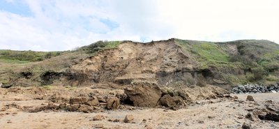
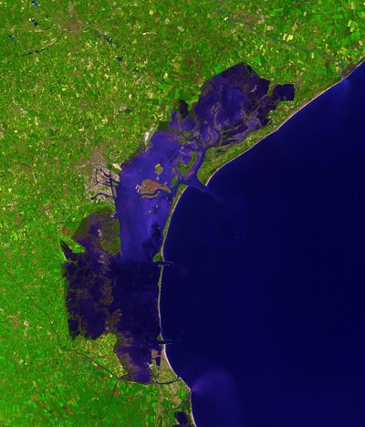
The database comes from the use of the PANDA (Notti et al., 2024) method to map the potential shallow landslides (PL) occurred during the extreme rainfall event happened the night of the 1st September 2025 in a central sector of Val Fontanabuona (Liguria, Italy). A pre-event image acquired on 7 September 2024 and a post-event image acquired on 1 October 2025 were used, obtained by Sentinel-2 satellites (https://browser.dataspace.copernicus.eu/), both filtered with a 30% cloud-cover threshold. Subsequently, the CloudMask layer (available in the S2 dataset) was added to filter. Then the NDVI (Normalized Difference Vegetation Index) was calculated both for the pre the post event images, to calculate its variation by using the subsequent formula: NDVIvar = NDVIpost - NDVIpre The 5-m DTM of Regione Liguria was used in order to filter the PL with the derived slope degree. In the end, to identify the PL polygons were used 2 thresholds: NDVI variation ≤ -0.15; Slope ≥ 15°; The preliminary polygons obtained by using these first thresholds were further filtered by: - Removing PLs that were within the shadows of the clouds, that were not included by the CloudMask. - Reclassifying PLs probably related to Hydraulic Processes using the distance from the polygon to the water bodies, and the percentage of area included inside the water course. Those polygons have been reclassified as HyP (Class 1). - Removing land use change (related to variations of vegetation), by using two other satellite images, one from 13 August 2024 and one from 5 August 2025. Those polygons have been reclassified as LuC (Class 2). The remaining polygons have been classified as Potential Landslides (Class 0). The polygons obtained from these filters are inside the “PL_valFontanabuona_202509001” geopackage. Then, inside “Ground_valFontanabuona_202509001” geopackage, it’s possible to find two validation points, that correspond to two geolocated ground truths based on photo and drone videos of landslides, published by the local news. Such information was used to validate the one identified by the PANDA method. Inside the attribute table, it is possible to find a field called “Validation” where there are the links to the local online news and drone flies. References: Notti, D., Cignetti, M., Godone, D., Cardone, D., & Giordan, D. (2024). The unsuPervised shAllow laNdslide rapiD mApping: PANDA method applied to severe rainfalls in northeastern appenine (Italy). International Journal of Applied Earth Observation and Geoinformation, 129, 103806. Local Team: https://www.localteam.it/video/nubifragi-liguria-frane-isolano-frazione-a-favale-di-malvaro-drone Il Secolo XIX: https://www.ilsecoloxix.it/liguria/2025/09/02/news/maltempo_frane_allagamenti_aggiornamenti-15291822/
Related Topics


- Type
- dataset
- Landing Page
- https://doi.org/10.5281/zenodo.17724370
- OA Status
- green
- OpenAlex ID
- https://openalex.org/W7106786891
Raw OpenAlex JSON
- OpenAlex ID
-
https://openalex.org/W7106786891Canonical identifier for this work in OpenAlex
- DOI
-
https://doi.org/10.5281/zenodo.17724370Digital Object Identifier
- Title
-
Potential Shallow Landslides 1 September 2025 Val Fontanabuona, Ligury, ItalyWork title
- Type
-
datasetOpenAlex work type
- Publication year
-
2025Year of publication
- Publication date
-
2025-11-26Full publication date if available
- Authors
-
Notti Davide, Bogliani, Eugenio MariaList of authors in order
- Landing page
-
https://doi.org/10.5281/zenodo.17724370Publisher landing page
- Open access
-
YesWhether a free full text is available
- OA status
-
greenOpen access status per OpenAlex
- OA URL
-
https://doi.org/10.5281/zenodo.17724370Direct OA link when available
- Concepts
-
Polygon (computer graphics), Normalized Difference Vegetation Index, Landslide, Geology, Vegetation (pathology), Physical geography, Remote sensing, Satellite, Hydrology (agriculture), Satellite imagery, Elevation (ballistics), Cartography, Filter (signal processing), Geomorphology, Spatial variability, Land cover, Event (particle physics), Variation (astronomy), Environmental science, Geography, Structural basin, Debris flow, Land useTop concepts (fields/topics) attached by OpenAlex
- Cited by
-
0Total citation count in OpenAlex
Full payload
| id | https://openalex.org/W7106786891 |
|---|---|
| doi | https://doi.org/10.5281/zenodo.17724370 |
| ids.doi | https://doi.org/10.5281/zenodo.17724370 |
| ids.openalex | https://openalex.org/W7106786891 |
| fwci | 0.0 |
| type | dataset |
| title | Potential Shallow Landslides 1 September 2025 Val Fontanabuona, Ligury, Italy |
| biblio.issue | |
| biblio.volume | |
| biblio.last_page | |
| biblio.first_page | |
| is_xpac | False |
| apc_list | |
| apc_paid | |
| concepts[0].id | https://openalex.org/C190694206 |
| concepts[0].level | 3 |
| concepts[0].score | 0.6772435307502747 |
| concepts[0].wikidata | https://www.wikidata.org/wiki/Q3276654 |
| concepts[0].display_name | Polygon (computer graphics) |
| concepts[1].id | https://openalex.org/C1549246 |
| concepts[1].level | 3 |
| concepts[1].score | 0.6672042012214661 |
| concepts[1].wikidata | https://www.wikidata.org/wiki/Q718775 |
| concepts[1].display_name | Normalized Difference Vegetation Index |
| concepts[2].id | https://openalex.org/C186295008 |
| concepts[2].level | 2 |
| concepts[2].score | 0.6403324604034424 |
| concepts[2].wikidata | https://www.wikidata.org/wiki/Q167903 |
| concepts[2].display_name | Landslide |
| concepts[3].id | https://openalex.org/C127313418 |
| concepts[3].level | 0 |
| concepts[3].score | 0.5140558481216431 |
| concepts[3].wikidata | https://www.wikidata.org/wiki/Q1069 |
| concepts[3].display_name | Geology |
| concepts[4].id | https://openalex.org/C2776133958 |
| concepts[4].level | 2 |
| concepts[4].score | 0.5060735940933228 |
| concepts[4].wikidata | https://www.wikidata.org/wiki/Q7918366 |
| concepts[4].display_name | Vegetation (pathology) |
| concepts[5].id | https://openalex.org/C100970517 |
| concepts[5].level | 1 |
| concepts[5].score | 0.4278954863548279 |
| concepts[5].wikidata | https://www.wikidata.org/wiki/Q52107 |
| concepts[5].display_name | Physical geography |
| concepts[6].id | https://openalex.org/C62649853 |
| concepts[6].level | 1 |
| concepts[6].score | 0.3900339901447296 |
| concepts[6].wikidata | https://www.wikidata.org/wiki/Q199687 |
| concepts[6].display_name | Remote sensing |
| concepts[7].id | https://openalex.org/C19269812 |
| concepts[7].level | 2 |
| concepts[7].score | 0.3790386915206909 |
| concepts[7].wikidata | https://www.wikidata.org/wiki/Q26540 |
| concepts[7].display_name | Satellite |
| concepts[8].id | https://openalex.org/C76886044 |
| concepts[8].level | 2 |
| concepts[8].score | 0.3767250180244446 |
| concepts[8].wikidata | https://www.wikidata.org/wiki/Q2883300 |
| concepts[8].display_name | Hydrology (agriculture) |
| concepts[9].id | https://openalex.org/C2778102629 |
| concepts[9].level | 2 |
| concepts[9].score | 0.36878103017807007 |
| concepts[9].wikidata | https://www.wikidata.org/wiki/Q725252 |
| concepts[9].display_name | Satellite imagery |
| concepts[10].id | https://openalex.org/C37054046 |
| concepts[10].level | 2 |
| concepts[10].score | 0.3550476133823395 |
| concepts[10].wikidata | https://www.wikidata.org/wiki/Q641888 |
| concepts[10].display_name | Elevation (ballistics) |
| concepts[11].id | https://openalex.org/C58640448 |
| concepts[11].level | 1 |
| concepts[11].score | 0.3306024670600891 |
| concepts[11].wikidata | https://www.wikidata.org/wiki/Q42515 |
| concepts[11].display_name | Cartography |
| concepts[12].id | https://openalex.org/C106131492 |
| concepts[12].level | 2 |
| concepts[12].score | 0.3211285471916199 |
| concepts[12].wikidata | https://www.wikidata.org/wiki/Q3072260 |
| concepts[12].display_name | Filter (signal processing) |
| concepts[13].id | https://openalex.org/C114793014 |
| concepts[13].level | 1 |
| concepts[13].score | 0.31250810623168945 |
| concepts[13].wikidata | https://www.wikidata.org/wiki/Q52109 |
| concepts[13].display_name | Geomorphology |
| concepts[14].id | https://openalex.org/C94747663 |
| concepts[14].level | 2 |
| concepts[14].score | 0.312256783246994 |
| concepts[14].wikidata | https://www.wikidata.org/wiki/Q7574086 |
| concepts[14].display_name | Spatial variability |
| concepts[15].id | https://openalex.org/C2780648208 |
| concepts[15].level | 3 |
| concepts[15].score | 0.29136332869529724 |
| concepts[15].wikidata | https://www.wikidata.org/wiki/Q3001793 |
| concepts[15].display_name | Land cover |
| concepts[16].id | https://openalex.org/C2779662365 |
| concepts[16].level | 2 |
| concepts[16].score | 0.2907765209674835 |
| concepts[16].wikidata | https://www.wikidata.org/wiki/Q5416694 |
| concepts[16].display_name | Event (particle physics) |
| concepts[17].id | https://openalex.org/C2778334786 |
| concepts[17].level | 2 |
| concepts[17].score | 0.27985963225364685 |
| concepts[17].wikidata | https://www.wikidata.org/wiki/Q1586270 |
| concepts[17].display_name | Variation (astronomy) |
| concepts[18].id | https://openalex.org/C39432304 |
| concepts[18].level | 0 |
| concepts[18].score | 0.27751198410987854 |
| concepts[18].wikidata | https://www.wikidata.org/wiki/Q188847 |
| concepts[18].display_name | Environmental science |
| concepts[19].id | https://openalex.org/C205649164 |
| concepts[19].level | 0 |
| concepts[19].score | 0.26527348160743713 |
| concepts[19].wikidata | https://www.wikidata.org/wiki/Q1071 |
| concepts[19].display_name | Geography |
| concepts[20].id | https://openalex.org/C109007969 |
| concepts[20].level | 2 |
| concepts[20].score | 0.25946247577667236 |
| concepts[20].wikidata | https://www.wikidata.org/wiki/Q749565 |
| concepts[20].display_name | Structural basin |
| concepts[21].id | https://openalex.org/C2776643431 |
| concepts[21].level | 3 |
| concepts[21].score | 0.25856906175613403 |
| concepts[21].wikidata | https://www.wikidata.org/wiki/Q1817963 |
| concepts[21].display_name | Debris flow |
| concepts[22].id | https://openalex.org/C4792198 |
| concepts[22].level | 2 |
| concepts[22].score | 0.2573259174823761 |
| concepts[22].wikidata | https://www.wikidata.org/wiki/Q1165944 |
| concepts[22].display_name | Land use |
| keywords[0].id | https://openalex.org/keywords/polygon |
| keywords[0].score | 0.6772435307502747 |
| keywords[0].display_name | Polygon (computer graphics) |
| keywords[1].id | https://openalex.org/keywords/normalized-difference-vegetation-index |
| keywords[1].score | 0.6672042012214661 |
| keywords[1].display_name | Normalized Difference Vegetation Index |
| keywords[2].id | https://openalex.org/keywords/landslide |
| keywords[2].score | 0.6403324604034424 |
| keywords[2].display_name | Landslide |
| keywords[3].id | https://openalex.org/keywords/vegetation |
| keywords[3].score | 0.5060735940933228 |
| keywords[3].display_name | Vegetation (pathology) |
| keywords[4].id | https://openalex.org/keywords/satellite |
| keywords[4].score | 0.3790386915206909 |
| keywords[4].display_name | Satellite |
| keywords[5].id | https://openalex.org/keywords/hydrology |
| keywords[5].score | 0.3767250180244446 |
| keywords[5].display_name | Hydrology (agriculture) |
| keywords[6].id | https://openalex.org/keywords/satellite-imagery |
| keywords[6].score | 0.36878103017807007 |
| keywords[6].display_name | Satellite imagery |
| keywords[7].id | https://openalex.org/keywords/elevation |
| keywords[7].score | 0.3550476133823395 |
| keywords[7].display_name | Elevation (ballistics) |
| language | |
| locations[0].id | doi:10.5281/zenodo.17724370 |
| locations[0].is_oa | True |
| locations[0].source.id | https://openalex.org/S4306400562 |
| locations[0].source.issn | |
| locations[0].source.type | repository |
| locations[0].source.is_oa | True |
| locations[0].source.issn_l | |
| locations[0].source.is_core | False |
| locations[0].source.is_in_doaj | False |
| locations[0].source.display_name | Zenodo (CERN European Organization for Nuclear Research) |
| locations[0].source.host_organization | https://openalex.org/I67311998 |
| locations[0].source.host_organization_name | European Organization for Nuclear Research |
| locations[0].source.host_organization_lineage | https://openalex.org/I67311998 |
| locations[0].license | cc-by |
| locations[0].pdf_url | |
| locations[0].version | |
| locations[0].raw_type | dataset |
| locations[0].license_id | https://openalex.org/licenses/cc-by |
| locations[0].is_accepted | False |
| locations[0].is_published | |
| locations[0].raw_source_name | |
| locations[0].landing_page_url | https://doi.org/10.5281/zenodo.17724370 |
| indexed_in | datacite |
| authorships[0].author.id | https://openalex.org/A3153646039 |
| authorships[0].author.orcid | |
| authorships[0].author.display_name | Notti Davide |
| authorships[0].countries | IT |
| authorships[0].affiliations[0].institution_ids | https://openalex.org/I4210091655 |
| authorships[0].affiliations[0].raw_affiliation_string | Research Institute for Geo-Hydrological Protection |
| authorships[0].institutions[0].id | https://openalex.org/I4210091655 |
| authorships[0].institutions[0].ror | https://ror.org/https://ror.org/0040zx077 |
| authorships[0].institutions[0].type | facility |
| authorships[0].institutions[0].lineage | https://openalex.org/I4210091655, https://openalex.org/I4210155236 |
| authorships[0].institutions[0].country_code | IT |
| authorships[0].institutions[0].display_name | Research Institute for Geo-Hydrological Protection |
| authorships[0].author_position | first |
| authorships[0].raw_author_name | Notti, Davide |
| authorships[0].is_corresponding | True |
| authorships[0].raw_affiliation_strings | Research Institute for Geo-Hydrological Protection |
| authorships[1].author.id | |
| authorships[1].author.orcid | |
| authorships[1].author.display_name | Bogliani, Eugenio Maria |
| authorships[1].countries | IT |
| authorships[1].affiliations[0].institution_ids | https://openalex.org/I189158943 |
| authorships[1].affiliations[0].raw_affiliation_string | University of Milan |
| authorships[1].institutions[0].id | https://openalex.org/I189158943 |
| authorships[1].institutions[0].ror | https://ror.org/https://ror.org/00wjc7c48 |
| authorships[1].institutions[0].type | education |
| authorships[1].institutions[0].lineage | https://openalex.org/I189158943 |
| authorships[1].institutions[0].country_code | IT |
| authorships[1].institutions[0].display_name | University of Milan |
| authorships[1].author_position | last |
| authorships[1].raw_author_name | Bogliani, Eugenio Maria |
| authorships[1].is_corresponding | False |
| authorships[1].raw_affiliation_strings | University of Milan |
| has_content.pdf | False |
| has_content.grobid_xml | False |
| is_paratext | False |
| open_access.is_oa | True |
| open_access.oa_url | https://doi.org/10.5281/zenodo.17724370 |
| open_access.oa_status | green |
| open_access.any_repository_has_fulltext | False |
| created_date | 2025-11-28T00:00:00 |
| display_name | Potential Shallow Landslides 1 September 2025 Val Fontanabuona, Ligury, Italy |
| has_fulltext | False |
| is_retracted | False |
| updated_date | 2025-11-28T02:12:24.556248 |
| primary_topic | |
| cited_by_count | 0 |
| locations_count | 1 |
| best_oa_location.id | doi:10.5281/zenodo.17724370 |
| best_oa_location.is_oa | True |
| best_oa_location.source.id | https://openalex.org/S4306400562 |
| best_oa_location.source.issn | |
| best_oa_location.source.type | repository |
| best_oa_location.source.is_oa | True |
| best_oa_location.source.issn_l | |
| best_oa_location.source.is_core | False |
| best_oa_location.source.is_in_doaj | False |
| best_oa_location.source.display_name | Zenodo (CERN European Organization for Nuclear Research) |
| best_oa_location.source.host_organization | https://openalex.org/I67311998 |
| best_oa_location.source.host_organization_name | European Organization for Nuclear Research |
| best_oa_location.source.host_organization_lineage | https://openalex.org/I67311998 |
| best_oa_location.license | cc-by |
| best_oa_location.pdf_url | |
| best_oa_location.version | |
| best_oa_location.raw_type | dataset |
| best_oa_location.license_id | https://openalex.org/licenses/cc-by |
| best_oa_location.is_accepted | False |
| best_oa_location.is_published | False |
| best_oa_location.raw_source_name | |
| best_oa_location.landing_page_url | https://doi.org/10.5281/zenodo.17724370 |
| primary_location.id | doi:10.5281/zenodo.17724370 |
| primary_location.is_oa | True |
| primary_location.source.id | https://openalex.org/S4306400562 |
| primary_location.source.issn | |
| primary_location.source.type | repository |
| primary_location.source.is_oa | True |
| primary_location.source.issn_l | |
| primary_location.source.is_core | False |
| primary_location.source.is_in_doaj | False |
| primary_location.source.display_name | Zenodo (CERN European Organization for Nuclear Research) |
| primary_location.source.host_organization | https://openalex.org/I67311998 |
| primary_location.source.host_organization_name | European Organization for Nuclear Research |
| primary_location.source.host_organization_lineage | https://openalex.org/I67311998 |
| primary_location.license | cc-by |
| primary_location.pdf_url | |
| primary_location.version | |
| primary_location.raw_type | dataset |
| primary_location.license_id | https://openalex.org/licenses/cc-by |
| primary_location.is_accepted | False |
| primary_location.is_published | False |
| primary_location.raw_source_name | |
| primary_location.landing_page_url | https://doi.org/10.5281/zenodo.17724370 |
| publication_date | 2025-11-26 |
| publication_year | 2025 |
| referenced_works_count | 0 |
| abstract_inverted_index.& | 362 |
| abstract_inverted_index.- | 117, 170, 188, 225 |
| abstract_inverted_index.1 | 58 |
| abstract_inverted_index.2 | 148 |
| abstract_inverted_index.5 | 249 |
| abstract_inverted_index.7 | 49 |
| abstract_inverted_index.= | 115 |
| abstract_inverted_index.A | 44 |
| abstract_inverted_index.a | 36, 53, 71, 336 |
| abstract_inverted_index.13 | 243 |
| abstract_inverted_index.D. | 364 |
| abstract_inverted_index.Il | 395 |
| abstract_inverted_index.In | 138 |
| abstract_inverted_index.PL | 132, 144 |
| abstract_inverted_index.S2 | 82 |
| abstract_inverted_index.as | 221, 257, 267 |
| abstract_inverted_index.by | 64, 109, 161, 185, 235, 310, 323 |
| abstract_inverted_index.et | 10 |
| abstract_inverted_index.in | 35, 80, 127, 378 |
| abstract_inverted_index.is | 332 |
| abstract_inverted_index.it | 331 |
| abstract_inverted_index.of | 6, 30, 39, 122, 178, 209, 233, 307, 384 |
| abstract_inverted_index.on | 48, 57, 302 |
| abstract_inverted_index.to | 14, 86, 105, 129, 141, 193, 202, 231, 289, 296, 318, 334, 345, 375 |
| abstract_inverted_index.0). | 271 |
| abstract_inverted_index.1). | 224 |
| abstract_inverted_index.1st | 32 |
| abstract_inverted_index.2). | 260 |
| abstract_inverted_index.30% | 72 |
| abstract_inverted_index.5-m | 120 |
| abstract_inverted_index.D., | 355, 359, 361 |
| abstract_inverted_index.DTM | 121 |
| abstract_inverted_index.HyP | 222 |
| abstract_inverted_index.LuC | 258 |
| abstract_inverted_index.M., | 357 |
| abstract_inverted_index.PLs | 172, 190 |
| abstract_inverted_index.The | 0, 119, 157, 261, 272, 366 |
| abstract_inverted_index.Val | 40 |
| abstract_inverted_index.and | 52, 206, 246, 304, 350, 388 |
| abstract_inverted_index.are | 278, 342 |
| abstract_inverted_index.by: | 169 |
| abstract_inverted_index.for | 98 |
| abstract_inverted_index.its | 107 |
| abstract_inverted_index.map | 15 |
| abstract_inverted_index.not | 183 |
| abstract_inverted_index.one | 241, 247, 321 |
| abstract_inverted_index.pre | 100 |
| abstract_inverted_index.the | 4, 7, 16, 23, 28, 31, 76, 81, 89, 99, 101, 111, 131, 134, 139, 143, 176, 179, 186, 197, 200, 203, 207, 213, 280, 311, 320, 324, 328, 343, 346 |
| abstract_inverted_index.two | 237, 291, 297 |
| abstract_inverted_index.use | 5, 228 |
| abstract_inverted_index.was | 84, 95, 125, 316 |
| abstract_inverted_index.≤ | 152 |
| abstract_inverted_index.≥ | 155 |
| abstract_inverted_index.(PL) | 20 |
| abstract_inverted_index.129, | 390 |
| abstract_inverted_index.2024 | 51, 245 |
| abstract_inverted_index.2025 | 34, 60 |
| abstract_inverted_index.NDVI | 90, 150 |
| abstract_inverted_index.Such | 314 |
| abstract_inverted_index.Then | 88 |
| abstract_inverted_index.XIX: | 397 |
| abstract_inverted_index.al., | 11 |
| abstract_inverted_index.area | 210 |
| abstract_inverted_index.been | 219, 255, 265 |
| abstract_inverted_index.both | 68, 97 |
| abstract_inverted_index.end, | 140 |
| abstract_inverted_index.find | 290, 335 |
| abstract_inverted_index.from | 3, 199, 242, 248, 275 |
| abstract_inverted_index.have | 218, 254, 264 |
| abstract_inverted_index.land | 227 |
| abstract_inverted_index.news | 349 |
| abstract_inverted_index.post | 102 |
| abstract_inverted_index.that | 173, 181, 294 |
| abstract_inverted_index.used | 126, 147, 317 |
| abstract_inverted_index.were | 61, 146, 166, 174, 182 |
| abstract_inverted_index.with | 70, 133 |
| abstract_inverted_index.15°; | 156 |
| abstract_inverted_index.2024) | 12 |
| abstract_inverted_index.2025. | 251 |
| abstract_inverted_index.Earth | 386 |
| abstract_inverted_index.Local | 392 |
| abstract_inverted_index.PANDA | 8, 325, 372 |
| abstract_inverted_index.Slope | 154 |
| abstract_inverted_index.Team: | 393 |
| abstract_inverted_index.Then, | 283 |
| abstract_inverted_index.Those | 216, 252 |
| abstract_inverted_index.added | 85 |
| abstract_inverted_index.based | 301 |
| abstract_inverted_index.comes | 2 |
| abstract_inverted_index.drone | 305, 351 |
| abstract_inverted_index.event | 26, 103 |
| abstract_inverted_index.field | 337 |
| abstract_inverted_index.first | 164 |
| abstract_inverted_index.image | 46, 55 |
| abstract_inverted_index.layer | 78 |
| abstract_inverted_index.links | 344 |
| abstract_inverted_index.local | 312, 347 |
| abstract_inverted_index.news. | 313 |
| abstract_inverted_index.night | 29 |
| abstract_inverted_index.order | 128 |
| abstract_inverted_index.other | 238 |
| abstract_inverted_index.photo | 303 |
| abstract_inverted_index.rapiD | 370 |
| abstract_inverted_index.slope | 136 |
| abstract_inverted_index.there | 341 |
| abstract_inverted_index.these | 163, 276 |
| abstract_inverted_index.used, | 62 |
| abstract_inverted_index.using | 110, 162, 196, 236 |
| abstract_inverted_index.water | 204, 214 |
| abstract_inverted_index.where | 340 |
| abstract_inverted_index.(Class | 223, 259, 270 |
| abstract_inverted_index.(Notti | 9 |
| abstract_inverted_index.-0.15; | 153 |
| abstract_inverted_index.August | 244, 250 |
| abstract_inverted_index.Index) | 94 |
| abstract_inverted_index.Inside | 327 |
| abstract_inverted_index.Notti, | 354 |
| abstract_inverted_index.Secolo | 396 |
| abstract_inverted_index.called | 338 |
| abstract_inverted_index.change | 229 |
| abstract_inverted_index.during | 22 |
| abstract_inverted_index.filter | 130 |
| abstract_inverted_index.flies. | 352 |
| abstract_inverted_index.ground | 299 |
| abstract_inverted_index.inside | 212, 279, 284 |
| abstract_inverted_index.it’s | 287 |
| abstract_inverted_index.method | 13, 373 |
| abstract_inverted_index.online | 348 |
| abstract_inverted_index.sector | 38 |
| abstract_inverted_index.severe | 376 |
| abstract_inverted_index.table, | 330 |
| abstract_inverted_index.truths | 300 |
| abstract_inverted_index.videos | 306 |
| abstract_inverted_index.within | 175 |
| abstract_inverted_index.(2024). | 365 |
| abstract_inverted_index.103806. | 391 |
| abstract_inverted_index.Applied | 385 |
| abstract_inverted_index.Godone, | 358 |
| abstract_inverted_index.Italy). | 43 |
| abstract_inverted_index.Journal | 383 |
| abstract_inverted_index.Liguria | 124 |
| abstract_inverted_index.NDVIpre | 118 |
| abstract_inverted_index.NDVIvar | 114 |
| abstract_inverted_index.October | 59 |
| abstract_inverted_index.Regione | 123 |
| abstract_inverted_index.applied | 374 |
| abstract_inverted_index.bodies, | 205 |
| abstract_inverted_index.central | 37 |
| abstract_inverted_index.clouds, | 180 |
| abstract_inverted_index.course. | 215 |
| abstract_inverted_index.degree. | 137 |
| abstract_inverted_index.derived | 135 |
| abstract_inverted_index.extreme | 24 |
| abstract_inverted_index.filter. | 87 |
| abstract_inverted_index.filters | 277 |
| abstract_inverted_index.further | 167 |
| abstract_inverted_index.images, | 104, 240 |
| abstract_inverted_index.method. | 326 |
| abstract_inverted_index.points, | 293 |
| abstract_inverted_index.polygon | 201 |
| abstract_inverted_index.related | 192 |
| abstract_inverted_index.shAllow | 368 |
| abstract_inverted_index.shadows | 177 |
| abstract_inverted_index.shallow | 18 |
| abstract_inverted_index.(Italy). | 381 |
| abstract_inverted_index.(related | 230 |
| abstract_inverted_index.Cardone, | 360 |
| abstract_inverted_index.Giordan, | 363 |
| abstract_inverted_index.NDVIpost | 116 |
| abstract_inverted_index.Removing | 171, 226 |
| abstract_inverted_index.acquired | 47, 56 |
| abstract_inverted_index.appenine | 380 |
| abstract_inverted_index.database | 1 |
| abstract_inverted_index.dataset) | 83 |
| abstract_inverted_index.distance | 198 |
| abstract_inverted_index.filtered | 69, 168 |
| abstract_inverted_index.formula: | 113 |
| abstract_inverted_index.happened | 27 |
| abstract_inverted_index.identify | 142 |
| abstract_inverted_index.included | 184, 211 |
| abstract_inverted_index.mApping: | 371 |
| abstract_inverted_index.obtained | 63, 160, 274 |
| abstract_inverted_index.occurred | 21 |
| abstract_inverted_index.polygons | 145, 159, 217, 253, 263, 273 |
| abstract_inverted_index.possible | 288, 333 |
| abstract_inverted_index.probably | 191 |
| abstract_inverted_index.rainfall | 25 |
| abstract_inverted_index.validate | 319 |
| abstract_inverted_index.(Liguria, | 42 |
| abstract_inverted_index.Cignetti, | 356 |
| abstract_inverted_index.CloudMask | 77 |
| abstract_inverted_index.Hydraulic | 194 |
| abstract_inverted_index.Potential | 268 |
| abstract_inverted_index.Processes | 195 |
| abstract_inverted_index.September | 33, 50 |
| abstract_inverted_index.attribute | 329 |
| abstract_inverted_index.calculate | 106 |
| abstract_inverted_index.laNdslide | 369 |
| abstract_inverted_index.potential | 17 |
| abstract_inverted_index.pre-event | 45 |
| abstract_inverted_index.published | 309 |
| abstract_inverted_index.rainfalls | 377 |
| abstract_inverted_index.remaining | 262 |
| abstract_inverted_index.satellite | 239 |
| abstract_inverted_index.variation | 108, 151 |
| abstract_inverted_index.(available | 79 |
| abstract_inverted_index.CloudMask. | 187 |
| abstract_inverted_index.Difference | 92 |
| abstract_inverted_index.Landslides | 269 |
| abstract_inverted_index.Sentinel-2 | 65 |
| abstract_inverted_index.Vegetation | 93 |
| abstract_inverted_index.calculated | 96 |
| abstract_inverted_index.classified | 266 |
| abstract_inverted_index.correspond | 295 |
| abstract_inverted_index.geolocated | 298 |
| abstract_inverted_index.identified | 322 |
| abstract_inverted_index.landslides | 19 |
| abstract_inverted_index.percentage | 208 |
| abstract_inverted_index.post-event | 54 |
| abstract_inverted_index.satellites | 66 |
| abstract_inverted_index.subsequent | 112 |
| abstract_inverted_index.threshold. | 74 |
| abstract_inverted_index.thresholds | 165 |
| abstract_inverted_index.validation | 292 |
| abstract_inverted_index.variations | 232 |
| abstract_inverted_index.(Normalized | 91 |
| abstract_inverted_index.Observation | 387 |
| abstract_inverted_index.References: | 353 |
| abstract_inverted_index.cloud-cover | 73 |
| abstract_inverted_index.geopackage, | 286 |
| abstract_inverted_index.geopackage. | 282 |
| abstract_inverted_index.information | 315 |
| abstract_inverted_index.landslides, | 308 |
| abstract_inverted_index.preliminary | 158 |
| abstract_inverted_index.thresholds: | 149 |
| abstract_inverted_index.Fontanabuona | 41 |
| abstract_inverted_index.northeastern | 379 |
| abstract_inverted_index.reclassified | 220, 256 |
| abstract_inverted_index.unsuPervised | 367 |
| abstract_inverted_index.vegetation), | 234 |
| abstract_inverted_index.International | 382 |
| abstract_inverted_index.Reclassifying | 189 |
| abstract_inverted_index.Subsequently, | 75 |
| abstract_inverted_index.Geoinformation, | 389 |
| abstract_inverted_index.“Validation” | 339 |
| abstract_inverted_index.“PL_valFontanabuona_202509001” | 281 |
| abstract_inverted_index.“Ground_valFontanabuona_202509001” | 285 |
| abstract_inverted_index.(https://browser.dataspace.copernicus.eu/), | 67 |
| abstract_inverted_index.https://www.localteam.it/video/nubifragi-liguria-frane-isolano-frazione-a-favale-di-malvaro-drone | 394 |
| abstract_inverted_index.https://www.ilsecoloxix.it/liguria/2025/09/02/news/maltempo_frane_allagamenti_aggiornamenti-15291822/ | 398 |
| cited_by_percentile_year | |
| countries_distinct_count | 1 |
| institutions_distinct_count | 2 |
| citation_normalized_percentile |