SHIFT: A DEM-Based Spatial Heterogeneity Improved Mapping of Global Geomorphic Floodplains Article Swipe
 YOU?
·
· 2024
· Open Access
·
· DOI: https://doi.org/10.5281/zenodo.10440608
YOU?
·
· 2024
· Open Access
·
· DOI: https://doi.org/10.5281/zenodo.10440608
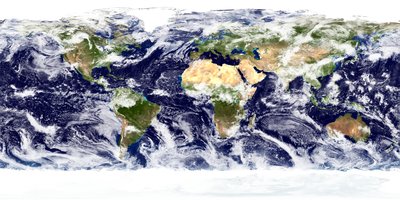
Description SHIFT (Spatial Heterogeneity Improved Floodplain by Terrain analysis) is a 90-m resolution global geomorphic floodplain map based on terrain analysis. It takes MERIT-Hydro as the terrain input and Floodplain Hydraulic Geometry (FHG) as the thresholding scheme, with the scaling parameters estimated by a stepwise framework that both respects the power law and approximates the spatial extent of hydrodynamic modeling. SHIFT effectively captures the global patterns of the geomorphic floodplains, with better regional details than existing data. Data Structure We provide 2 resolutions of data for different needs. SHIFT_v3_90m: The original SHIFT data derived from MERIT-Hydro, with lakes and reservoirs removed. The resolution is 0.000833333333333 degrees under geographic coordinate system (EPSG:4326), approximately 90 meters at the equator. Pixels with value 1 are floodplains, 2 are lakes and reservoirs and 0 are non-floodplains, with empty values set as 255 (denoting pixels not within any watersheds under the threshold of 1000 km2). SHIFT_v3_1km: The resampled SHIFT data with lakes and reservoirs marked. The resolution is 0.00833333333333 degrees under geographic coordinate system (EPSG:4326), approximately 1 km at the equator. Pixels with value 1 are floodplains, 2 are lakes and reservoirs and 0 are non-floodplains, with empty values set as 255 (denoting pixels not within any watersheds under the threshold of 1000 km2). Additional Version – SHIFT_v3a: We also provide an alternative Version 3a, which does not apply the GLWD lake mask. Other aspects of this version remain consistent with the standard SHIFT_v3 data. In this version, the presence of lakes is entirely determined by the terrain representation in MERIT-Hydro. This allows users to study lakeside floodplains that are influenced by riverine flooding processes. Thanks to Dr. Jida Wang for his kind suggestion. Also, we provide our derived spatially-varying parameters in all Level-3 basins to support future studies. Parameters are provided in a shapefile, with 'a' denotes the proportional parameter and 'b' denotes the exponent. We aggregated MERIT-Basins based on its spatial relationship with basins from Level-3 HydroBASINS, ensuring that the centroid of a MERIT-Basin falls within the corresponding boundary. This approach accounts for slight differences in boundaries due to the use of different terrain data, preventing confusion in hydrological representation. For more details, please refer to: Zheng, K., Lin, P., and Yin, Z.: SHIFT: a spatial-heterogeneity improvement in DEM-based mapping of global geomorphic floodplains, Earth Syst. Sci. Data, 16, 3873–3891, https://doi.org/10.5194/essd-16-3873-2024, 2024. Development Log Changes in v3a: Introduction of Version 3a without GLWD Lake Mask. Version 3a removes the masking of lakes from the GLWD dataset, thereby retaining lakes present in the MERIT-Hydro dataset. This allows users to more accurately analyze lakeside floodplains that interact with riverine flooding processes. Changes in v3 compared to v2: Inclusion of Missing Level-3 Basin: We have added a previously missing Level-3 basin (PFAF ID: 242) that covers an area in Eastern Europe, specifically from Warsaw to Minsk. This omission was due to a technical problem that has now been resolved. Data are now still available in two resolutions: 90-meter and 1-kilometer. Updated Parameters: Along with the new boundaries, updated parameters are provided in the shapefile. Re-estimated Global Floodplain Area: Based on the new data, we have re-estimated the global total floodplain area from 9.9 × 10^6 km² to 9.92 × 10^6 km². This area still represents approximately 6.6% of the total land mass. Changes in v2 compared to v1: Parameter 'b' Estimation: We modified the technical details of parameter 'b' estimation, specifically the binning parameter, adding a constraining mechanism to handle data noise. This resulted in stabler estimates for large basins and a clearer pattern of global residual uncertainty. Target Function for Parameter 'a': We changed our target function to balance information from both datasets, using Fleiss’s Kappa (FK) and a penalty term to reduce bias. Contacts Kaihao Zheng, [email protected] Peirong Lin, [email protected]
Related Topics


- Type
- dataset
- Language
- en
- Landing Page
- https://doi.org/10.5281/zenodo.10440608
- OA Status
- green
- Related Works
- 10
- OpenAlex ID
- https://openalex.org/W4393881332
Raw OpenAlex JSON
- OpenAlex ID
-
https://openalex.org/W4393881332Canonical identifier for this work in OpenAlex
- DOI
-
https://doi.org/10.5281/zenodo.10440608Digital Object Identifier
- Title
-
SHIFT: A DEM-Based Spatial Heterogeneity Improved Mapping of Global Geomorphic FloodplainsWork title
- Type
-
datasetOpenAlex work type
- Language
-
enPrimary language
- Publication year
-
2024Year of publication
- Publication date
-
2024-07-02Full publication date if available
- Authors
-
Kaihao Zheng, Peirong Lin, Ziyun YinList of authors in order
- Landing page
-
https://doi.org/10.5281/zenodo.10440608Publisher landing page
- Open access
-
YesWhether a free full text is available
- OA status
-
greenOpen access status per OpenAlex
- OA URL
-
https://doi.org/10.5281/zenodo.10440608Direct OA link when available
- Concepts
-
Floodplain, Geography, Physical geography, Cartography, Hydrology (agriculture), Geology, Geotechnical engineeringTop concepts (fields/topics) attached by OpenAlex
- Cited by
-
0Total citation count in OpenAlex
- Related works (count)
-
10Other works algorithmically related by OpenAlex
Full payload
| id | https://openalex.org/W4393881332 |
|---|---|
| doi | https://doi.org/10.5281/zenodo.10440608 |
| ids.doi | https://doi.org/10.5281/zenodo.10440608 |
| ids.openalex | https://openalex.org/W4393881332 |
| fwci | |
| type | dataset |
| title | SHIFT: A DEM-Based Spatial Heterogeneity Improved Mapping of Global Geomorphic Floodplains |
| biblio.issue | |
| biblio.volume | |
| biblio.last_page | |
| biblio.first_page | |
| topics[0].id | https://openalex.org/T10330 |
| topics[0].field.id | https://openalex.org/fields/23 |
| topics[0].field.display_name | Environmental Science |
| topics[0].score | 0.9728000164031982 |
| topics[0].domain.id | https://openalex.org/domains/3 |
| topics[0].domain.display_name | Physical Sciences |
| topics[0].subfield.id | https://openalex.org/subfields/2312 |
| topics[0].subfield.display_name | Water Science and Technology |
| topics[0].display_name | Hydrology and Watershed Management Studies |
| topics[1].id | https://openalex.org/T10644 |
| topics[1].field.id | https://openalex.org/fields/19 |
| topics[1].field.display_name | Earth and Planetary Sciences |
| topics[1].score | 0.9621000289916992 |
| topics[1].domain.id | https://openalex.org/domains/3 |
| topics[1].domain.display_name | Physical Sciences |
| topics[1].subfield.id | https://openalex.org/subfields/1902 |
| topics[1].subfield.display_name | Atmospheric Science |
| topics[1].display_name | Cryospheric studies and observations |
| topics[2].id | https://openalex.org/T10757 |
| topics[2].field.id | https://openalex.org/fields/33 |
| topics[2].field.display_name | Social Sciences |
| topics[2].score | 0.9261000156402588 |
| topics[2].domain.id | https://openalex.org/domains/2 |
| topics[2].domain.display_name | Social Sciences |
| topics[2].subfield.id | https://openalex.org/subfields/3305 |
| topics[2].subfield.display_name | Geography, Planning and Development |
| topics[2].display_name | Geographic Information Systems Studies |
| is_xpac | False |
| apc_list | |
| apc_paid | |
| concepts[0].id | https://openalex.org/C155681218 |
| concepts[0].level | 2 |
| concepts[0].score | 0.795291006565094 |
| concepts[0].wikidata | https://www.wikidata.org/wiki/Q193110 |
| concepts[0].display_name | Floodplain |
| concepts[1].id | https://openalex.org/C205649164 |
| concepts[1].level | 0 |
| concepts[1].score | 0.5320547223091125 |
| concepts[1].wikidata | https://www.wikidata.org/wiki/Q1071 |
| concepts[1].display_name | Geography |
| concepts[2].id | https://openalex.org/C100970517 |
| concepts[2].level | 1 |
| concepts[2].score | 0.45972058176994324 |
| concepts[2].wikidata | https://www.wikidata.org/wiki/Q52107 |
| concepts[2].display_name | Physical geography |
| concepts[3].id | https://openalex.org/C58640448 |
| concepts[3].level | 1 |
| concepts[3].score | 0.407992959022522 |
| concepts[3].wikidata | https://www.wikidata.org/wiki/Q42515 |
| concepts[3].display_name | Cartography |
| concepts[4].id | https://openalex.org/C76886044 |
| concepts[4].level | 2 |
| concepts[4].score | 0.32931947708129883 |
| concepts[4].wikidata | https://www.wikidata.org/wiki/Q2883300 |
| concepts[4].display_name | Hydrology (agriculture) |
| concepts[5].id | https://openalex.org/C127313418 |
| concepts[5].level | 0 |
| concepts[5].score | 0.31535249948501587 |
| concepts[5].wikidata | https://www.wikidata.org/wiki/Q1069 |
| concepts[5].display_name | Geology |
| concepts[6].id | https://openalex.org/C187320778 |
| concepts[6].level | 1 |
| concepts[6].score | 0.0 |
| concepts[6].wikidata | https://www.wikidata.org/wiki/Q1349130 |
| concepts[6].display_name | Geotechnical engineering |
| keywords[0].id | https://openalex.org/keywords/floodplain |
| keywords[0].score | 0.795291006565094 |
| keywords[0].display_name | Floodplain |
| keywords[1].id | https://openalex.org/keywords/geography |
| keywords[1].score | 0.5320547223091125 |
| keywords[1].display_name | Geography |
| keywords[2].id | https://openalex.org/keywords/physical-geography |
| keywords[2].score | 0.45972058176994324 |
| keywords[2].display_name | Physical geography |
| keywords[3].id | https://openalex.org/keywords/cartography |
| keywords[3].score | 0.407992959022522 |
| keywords[3].display_name | Cartography |
| keywords[4].id | https://openalex.org/keywords/hydrology |
| keywords[4].score | 0.32931947708129883 |
| keywords[4].display_name | Hydrology (agriculture) |
| keywords[5].id | https://openalex.org/keywords/geology |
| keywords[5].score | 0.31535249948501587 |
| keywords[5].display_name | Geology |
| language | en |
| locations[0].id | doi:10.5281/zenodo.10440608 |
| locations[0].is_oa | True |
| locations[0].source.id | https://openalex.org/S4306400562 |
| locations[0].source.issn | |
| locations[0].source.type | repository |
| locations[0].source.is_oa | True |
| locations[0].source.issn_l | |
| locations[0].source.is_core | False |
| locations[0].source.is_in_doaj | False |
| locations[0].source.display_name | Zenodo (CERN European Organization for Nuclear Research) |
| locations[0].source.host_organization | https://openalex.org/I67311998 |
| locations[0].source.host_organization_name | European Organization for Nuclear Research |
| locations[0].source.host_organization_lineage | https://openalex.org/I67311998 |
| locations[0].license | cc-by |
| locations[0].pdf_url | |
| locations[0].version | |
| locations[0].raw_type | dataset |
| locations[0].license_id | https://openalex.org/licenses/cc-by |
| locations[0].is_accepted | False |
| locations[0].is_published | |
| locations[0].raw_source_name | |
| locations[0].landing_page_url | https://doi.org/10.5281/zenodo.10440608 |
| indexed_in | datacite |
| authorships[0].author.id | https://openalex.org/A5028003859 |
| authorships[0].author.orcid | https://orcid.org/0000-0003-3722-4772 |
| authorships[0].author.display_name | Kaihao Zheng |
| authorships[0].countries | CN |
| authorships[0].affiliations[0].institution_ids | https://openalex.org/I20231570 |
| authorships[0].affiliations[0].raw_affiliation_string | Peking University |
| authorships[0].institutions[0].id | https://openalex.org/I20231570 |
| authorships[0].institutions[0].ror | https://ror.org/02v51f717 |
| authorships[0].institutions[0].type | education |
| authorships[0].institutions[0].lineage | https://openalex.org/I20231570 |
| authorships[0].institutions[0].country_code | CN |
| authorships[0].institutions[0].display_name | Peking University |
| authorships[0].author_position | first |
| authorships[0].raw_author_name | Kaihao Zheng |
| authorships[0].is_corresponding | False |
| authorships[0].raw_affiliation_strings | Peking University |
| authorships[1].author.id | https://openalex.org/A5052980639 |
| authorships[1].author.orcid | https://orcid.org/0000-0002-7275-7470 |
| authorships[1].author.display_name | Peirong Lin |
| authorships[1].countries | CN |
| authorships[1].affiliations[0].institution_ids | https://openalex.org/I20231570 |
| authorships[1].affiliations[0].raw_affiliation_string | Peking University |
| authorships[1].institutions[0].id | https://openalex.org/I20231570 |
| authorships[1].institutions[0].ror | https://ror.org/02v51f717 |
| authorships[1].institutions[0].type | education |
| authorships[1].institutions[0].lineage | https://openalex.org/I20231570 |
| authorships[1].institutions[0].country_code | CN |
| authorships[1].institutions[0].display_name | Peking University |
| authorships[1].author_position | middle |
| authorships[1].raw_author_name | Peirong Lin |
| authorships[1].is_corresponding | False |
| authorships[1].raw_affiliation_strings | Peking University |
| authorships[2].author.id | https://openalex.org/A5089879560 |
| authorships[2].author.orcid | https://orcid.org/0000-0001-8665-9647 |
| authorships[2].author.display_name | Ziyun Yin |
| authorships[2].countries | CN |
| authorships[2].affiliations[0].institution_ids | https://openalex.org/I20231570 |
| authorships[2].affiliations[0].raw_affiliation_string | Peking University |
| authorships[2].institutions[0].id | https://openalex.org/I20231570 |
| authorships[2].institutions[0].ror | https://ror.org/02v51f717 |
| authorships[2].institutions[0].type | education |
| authorships[2].institutions[0].lineage | https://openalex.org/I20231570 |
| authorships[2].institutions[0].country_code | CN |
| authorships[2].institutions[0].display_name | Peking University |
| authorships[2].author_position | last |
| authorships[2].raw_author_name | Ziyun Yin |
| authorships[2].is_corresponding | False |
| authorships[2].raw_affiliation_strings | Peking University |
| has_content.pdf | False |
| has_content.grobid_xml | False |
| is_paratext | False |
| open_access.is_oa | True |
| open_access.oa_url | https://doi.org/10.5281/zenodo.10440608 |
| open_access.oa_status | green |
| open_access.any_repository_has_fulltext | False |
| created_date | 2025-10-10T00:00:00 |
| display_name | SHIFT: A DEM-Based Spatial Heterogeneity Improved Mapping of Global Geomorphic Floodplains |
| has_fulltext | False |
| is_retracted | False |
| updated_date | 2025-12-01T00:03:43.161839 |
| primary_topic.id | https://openalex.org/T10330 |
| primary_topic.field.id | https://openalex.org/fields/23 |
| primary_topic.field.display_name | Environmental Science |
| primary_topic.score | 0.9728000164031982 |
| primary_topic.domain.id | https://openalex.org/domains/3 |
| primary_topic.domain.display_name | Physical Sciences |
| primary_topic.subfield.id | https://openalex.org/subfields/2312 |
| primary_topic.subfield.display_name | Water Science and Technology |
| primary_topic.display_name | Hydrology and Watershed Management Studies |
| related_works | https://openalex.org/W4287219441, https://openalex.org/W1967818403, https://openalex.org/W2072260444, https://openalex.org/W2151028340, https://openalex.org/W2799948116, https://openalex.org/W284174281, https://openalex.org/W3119439396, https://openalex.org/W2131822697, https://openalex.org/W3130806769, https://openalex.org/W2625038719 |
| cited_by_count | 0 |
| locations_count | 1 |
| best_oa_location.id | doi:10.5281/zenodo.10440608 |
| best_oa_location.is_oa | True |
| best_oa_location.source.id | https://openalex.org/S4306400562 |
| best_oa_location.source.issn | |
| best_oa_location.source.type | repository |
| best_oa_location.source.is_oa | True |
| best_oa_location.source.issn_l | |
| best_oa_location.source.is_core | False |
| best_oa_location.source.is_in_doaj | False |
| best_oa_location.source.display_name | Zenodo (CERN European Organization for Nuclear Research) |
| best_oa_location.source.host_organization | https://openalex.org/I67311998 |
| best_oa_location.source.host_organization_name | European Organization for Nuclear Research |
| best_oa_location.source.host_organization_lineage | https://openalex.org/I67311998 |
| best_oa_location.license | cc-by |
| best_oa_location.pdf_url | |
| best_oa_location.version | |
| best_oa_location.raw_type | dataset |
| best_oa_location.license_id | https://openalex.org/licenses/cc-by |
| best_oa_location.is_accepted | False |
| best_oa_location.is_published | False |
| best_oa_location.raw_source_name | |
| best_oa_location.landing_page_url | https://doi.org/10.5281/zenodo.10440608 |
| primary_location.id | doi:10.5281/zenodo.10440608 |
| primary_location.is_oa | True |
| primary_location.source.id | https://openalex.org/S4306400562 |
| primary_location.source.issn | |
| primary_location.source.type | repository |
| primary_location.source.is_oa | True |
| primary_location.source.issn_l | |
| primary_location.source.is_core | False |
| primary_location.source.is_in_doaj | False |
| primary_location.source.display_name | Zenodo (CERN European Organization for Nuclear Research) |
| primary_location.source.host_organization | https://openalex.org/I67311998 |
| primary_location.source.host_organization_name | European Organization for Nuclear Research |
| primary_location.source.host_organization_lineage | https://openalex.org/I67311998 |
| primary_location.license | cc-by |
| primary_location.pdf_url | |
| primary_location.version | |
| primary_location.raw_type | dataset |
| primary_location.license_id | https://openalex.org/licenses/cc-by |
| primary_location.is_accepted | False |
| primary_location.is_published | False |
| primary_location.raw_source_name | |
| primary_location.landing_page_url | https://doi.org/10.5281/zenodo.10440608 |
| publication_date | 2024-07-02 |
| publication_year | 2024 |
| referenced_works_count | 0 |
| abstract_inverted_index.0 | 129, 188 |
| abstract_inverted_index.1 | 120, 171, 179 |
| abstract_inverted_index.2 | 81, 123, 182 |
| abstract_inverted_index.a | 10, 43, 298, 329, 371, 450, 475, 569, 585, 613 |
| abstract_inverted_index.3a | 397, 403 |
| abstract_inverted_index.90 | 112 |
| abstract_inverted_index.In | 240 |
| abstract_inverted_index.It | 21 |
| abstract_inverted_index.We | 79, 213, 311, 447, 555, 597 |
| abstract_inverted_index.an | 216, 460 |
| abstract_inverted_index.as | 24, 33, 136, 195 |
| abstract_inverted_index.at | 114, 173 |
| abstract_inverted_index.by | 6, 42, 250, 266 |
| abstract_inverted_index.in | 254, 286, 297, 342, 354, 374, 392, 417, 437, 462, 488, 505, 547, 578 |
| abstract_inverted_index.is | 9, 103, 162, 247 |
| abstract_inverted_index.km | 172 |
| abstract_inverted_index.of | 57, 66, 83, 147, 206, 230, 245, 328, 348, 377, 395, 407, 443, 541, 560, 588 |
| abstract_inverted_index.on | 18, 315, 513 |
| abstract_inverted_index.to | 259, 271, 290, 345, 424, 440, 468, 474, 530, 550, 572, 602, 616 |
| abstract_inverted_index.v2 | 548 |
| abstract_inverted_index.v3 | 438 |
| abstract_inverted_index.we | 280, 517 |
| abstract_inverted_index.× | 527, 532 |
| abstract_inverted_index.'a' | 301 |
| abstract_inverted_index.'b' | 307, 553, 562 |
| abstract_inverted_index.16, | 385 |
| abstract_inverted_index.255 | 137, 196 |
| abstract_inverted_index.3a, | 219 |
| abstract_inverted_index.9.9 | 526 |
| abstract_inverted_index.Dr. | 272 |
| abstract_inverted_index.For | 357 |
| abstract_inverted_index.ID: | 456 |
| abstract_inverted_index.K., | 364 |
| abstract_inverted_index.Log | 390 |
| abstract_inverted_index.P., | 366 |
| abstract_inverted_index.The | 89, 101, 151, 160 |
| abstract_inverted_index.Z.: | 369 |
| abstract_inverted_index.all | 287 |
| abstract_inverted_index.and | 28, 52, 98, 126, 128, 157, 185, 187, 306, 367, 492, 584, 612 |
| abstract_inverted_index.any | 142, 201 |
| abstract_inverted_index.are | 121, 124, 130, 180, 183, 189, 264, 295, 484, 503 |
| abstract_inverted_index.due | 344, 473 |
| abstract_inverted_index.for | 85, 275, 339, 581, 594 |
| abstract_inverted_index.has | 479 |
| abstract_inverted_index.his | 276 |
| abstract_inverted_index.its | 316 |
| abstract_inverted_index.law | 51 |
| abstract_inverted_index.map | 16 |
| abstract_inverted_index.new | 499, 515 |
| abstract_inverted_index.not | 140, 199, 222 |
| abstract_inverted_index.now | 480, 485 |
| abstract_inverted_index.our | 282, 599 |
| abstract_inverted_index.set | 135, 194 |
| abstract_inverted_index.the | 25, 34, 38, 49, 54, 63, 67, 115, 145, 174, 204, 224, 236, 243, 251, 303, 309, 326, 333, 346, 405, 410, 418, 498, 506, 514, 520, 542, 557, 565 |
| abstract_inverted_index.to: | 362 |
| abstract_inverted_index.two | 489 |
| abstract_inverted_index.use | 347 |
| abstract_inverted_index.v1: | 551 |
| abstract_inverted_index.v2: | 441 |
| abstract_inverted_index.was | 472 |
| abstract_inverted_index.– | 211 |
| abstract_inverted_index.'a': | 596 |
| abstract_inverted_index.(FK) | 611 |
| abstract_inverted_index.1000 | 148, 207 |
| abstract_inverted_index.10^6 | 528, 533 |
| abstract_inverted_index.242) | 457 |
| abstract_inverted_index.6.6% | 540 |
| abstract_inverted_index.9.92 | 531 |
| abstract_inverted_index.90-m | 11 |
| abstract_inverted_index.Data | 77, 483 |
| abstract_inverted_index.GLWD | 225, 399, 411 |
| abstract_inverted_index.Jida | 273 |
| abstract_inverted_index.Lake | 400 |
| abstract_inverted_index.Lin, | 365, 624 |
| abstract_inverted_index.Sci. | 383 |
| abstract_inverted_index.This | 256, 336, 421, 470, 535, 576 |
| abstract_inverted_index.Wang | 274 |
| abstract_inverted_index.Yin, | 368 |
| abstract_inverted_index.also | 214 |
| abstract_inverted_index.area | 461, 524, 536 |
| abstract_inverted_index.been | 481 |
| abstract_inverted_index.both | 47, 606 |
| abstract_inverted_index.data | 84, 92, 154, 574 |
| abstract_inverted_index.does | 221 |
| abstract_inverted_index.from | 94, 321, 409, 466, 525, 605 |
| abstract_inverted_index.have | 448, 518 |
| abstract_inverted_index.kind | 277 |
| abstract_inverted_index.km² | 529 |
| abstract_inverted_index.lake | 226 |
| abstract_inverted_index.land | 544 |
| abstract_inverted_index.more | 358, 425 |
| abstract_inverted_index.term | 615 |
| abstract_inverted_index.than | 74 |
| abstract_inverted_index.that | 46, 263, 325, 430, 458, 478 |
| abstract_inverted_index.this | 231, 241 |
| abstract_inverted_index.v3a: | 393 |
| abstract_inverted_index.with | 37, 70, 96, 118, 132, 155, 177, 191, 235, 300, 319, 432, 497 |
| abstract_inverted_index.(FHG) | 32 |
| abstract_inverted_index.(PFAF | 455 |
| abstract_inverted_index.2024. | 388 |
| abstract_inverted_index.Along | 496 |
| abstract_inverted_index.Also, | 279 |
| abstract_inverted_index.Area: | 511 |
| abstract_inverted_index.Based | 512 |
| abstract_inverted_index.Data, | 384 |
| abstract_inverted_index.Earth | 381 |
| abstract_inverted_index.Kappa | 610 |
| abstract_inverted_index.Mask. | 401 |
| abstract_inverted_index.Other | 228 |
| abstract_inverted_index.SHIFT | 1, 60, 91, 153 |
| abstract_inverted_index.Syst. | 382 |
| abstract_inverted_index.added | 449 |
| abstract_inverted_index.apply | 223 |
| abstract_inverted_index.based | 17, 314 |
| abstract_inverted_index.basin | 454 |
| abstract_inverted_index.bias. | 618 |
| abstract_inverted_index.data, | 351, 516 |
| abstract_inverted_index.data. | 76, 239 |
| abstract_inverted_index.empty | 133, 192 |
| abstract_inverted_index.falls | 331 |
| abstract_inverted_index.input | 27 |
| abstract_inverted_index.km2). | 149, 208 |
| abstract_inverted_index.km². | 534 |
| abstract_inverted_index.lakes | 97, 125, 156, 184, 246, 408, 415 |
| abstract_inverted_index.large | 582 |
| abstract_inverted_index.mask. | 227 |
| abstract_inverted_index.mass. | 545 |
| abstract_inverted_index.power | 50 |
| abstract_inverted_index.refer | 361 |
| abstract_inverted_index.still | 486, 537 |
| abstract_inverted_index.study | 260 |
| abstract_inverted_index.takes | 22 |
| abstract_inverted_index.total | 522, 543 |
| abstract_inverted_index.under | 106, 144, 165, 203 |
| abstract_inverted_index.users | 258, 423 |
| abstract_inverted_index.using | 608 |
| abstract_inverted_index.value | 119, 178 |
| abstract_inverted_index.which | 220 |
| abstract_inverted_index.Basin: | 446 |
| abstract_inverted_index.Global | 509 |
| abstract_inverted_index.Kaihao | 620 |
| abstract_inverted_index.Minsk. | 469 |
| abstract_inverted_index.Pixels | 117, 176 |
| abstract_inverted_index.SHIFT: | 370 |
| abstract_inverted_index.Target | 592 |
| abstract_inverted_index.Thanks | 270 |
| abstract_inverted_index.Warsaw | 467 |
| abstract_inverted_index.Zheng, | 363, 621 |
| abstract_inverted_index.adding | 568 |
| abstract_inverted_index.allows | 257, 422 |
| abstract_inverted_index.basins | 289, 320, 583 |
| abstract_inverted_index.better | 71 |
| abstract_inverted_index.covers | 459 |
| abstract_inverted_index.extent | 56 |
| abstract_inverted_index.future | 292 |
| abstract_inverted_index.global | 13, 64, 378, 521, 589 |
| abstract_inverted_index.handle | 573 |
| abstract_inverted_index.meters | 113 |
| abstract_inverted_index.needs. | 87 |
| abstract_inverted_index.noise. | 575 |
| abstract_inverted_index.pixels | 139, 198 |
| abstract_inverted_index.please | 360 |
| abstract_inverted_index.reduce | 617 |
| abstract_inverted_index.remain | 233 |
| abstract_inverted_index.slight | 340 |
| abstract_inverted_index.system | 109, 168 |
| abstract_inverted_index.target | 600 |
| abstract_inverted_index.values | 134, 193 |
| abstract_inverted_index.within | 141, 200, 332 |
| abstract_inverted_index.Changes | 391, 436, 546 |
| abstract_inverted_index.Eastern | 463 |
| abstract_inverted_index.Europe, | 464 |
| abstract_inverted_index.Level-3 | 288, 322, 445, 453 |
| abstract_inverted_index.Missing | 444 |
| abstract_inverted_index.Peirong | 623 |
| abstract_inverted_index.Terrain | 7 |
| abstract_inverted_index.Updated | 494 |
| abstract_inverted_index.Version | 210, 218, 396, 402 |
| abstract_inverted_index.analyze | 427 |
| abstract_inverted_index.aspects | 229 |
| abstract_inverted_index.balance | 603 |
| abstract_inverted_index.binning | 566 |
| abstract_inverted_index.changed | 598 |
| abstract_inverted_index.clearer | 586 |
| abstract_inverted_index.degrees | 105, 164 |
| abstract_inverted_index.denotes | 302, 308 |
| abstract_inverted_index.derived | 93, 283 |
| abstract_inverted_index.details | 73, 559 |
| abstract_inverted_index.mapping | 376 |
| abstract_inverted_index.marked. | 159 |
| abstract_inverted_index.masking | 406 |
| abstract_inverted_index.missing | 452 |
| abstract_inverted_index.pattern | 587 |
| abstract_inverted_index.penalty | 614 |
| abstract_inverted_index.present | 416 |
| abstract_inverted_index.problem | 477 |
| abstract_inverted_index.provide | 80, 215, 281 |
| abstract_inverted_index.removes | 404 |
| abstract_inverted_index.scaling | 39 |
| abstract_inverted_index.scheme, | 36 |
| abstract_inverted_index.spatial | 55, 317 |
| abstract_inverted_index.stabler | 579 |
| abstract_inverted_index.support | 291 |
| abstract_inverted_index.terrain | 19, 26, 252, 350 |
| abstract_inverted_index.thereby | 413 |
| abstract_inverted_index.updated | 501 |
| abstract_inverted_index.version | 232 |
| abstract_inverted_index.without | 398 |
| abstract_inverted_index.(Spatial | 2 |
| abstract_inverted_index.90-meter | 491 |
| abstract_inverted_index.Contacts | 619 |
| abstract_inverted_index.Function | 593 |
| abstract_inverted_index.Geometry | 31 |
| abstract_inverted_index.Improved | 4 |
| abstract_inverted_index.SHIFT_v3 | 238 |
| abstract_inverted_index.accounts | 338 |
| abstract_inverted_index.approach | 337 |
| abstract_inverted_index.captures | 62 |
| abstract_inverted_index.centroid | 327 |
| abstract_inverted_index.compared | 439, 549 |
| abstract_inverted_index.dataset, | 412 |
| abstract_inverted_index.dataset. | 420 |
| abstract_inverted_index.details, | 359 |
| abstract_inverted_index.ensuring | 324 |
| abstract_inverted_index.entirely | 248 |
| abstract_inverted_index.equator. | 116, 175 |
| abstract_inverted_index.existing | 75 |
| abstract_inverted_index.flooding | 268, 434 |
| abstract_inverted_index.function | 601 |
| abstract_inverted_index.interact | 431 |
| abstract_inverted_index.lakeside | 261, 428 |
| abstract_inverted_index.modified | 556 |
| abstract_inverted_index.omission | 471 |
| abstract_inverted_index.original | 90 |
| abstract_inverted_index.patterns | 65 |
| abstract_inverted_index.presence | 244 |
| abstract_inverted_index.provided | 296, 504 |
| abstract_inverted_index.regional | 72 |
| abstract_inverted_index.removed. | 100 |
| abstract_inverted_index.residual | 590 |
| abstract_inverted_index.respects | 48 |
| abstract_inverted_index.resulted | 577 |
| abstract_inverted_index.riverine | 267, 433 |
| abstract_inverted_index.standard | 237 |
| abstract_inverted_index.stepwise | 44 |
| abstract_inverted_index.studies. | 293 |
| abstract_inverted_index.version, | 242 |
| abstract_inverted_index.(denoting | 138, 197 |
| abstract_inverted_index.DEM-based | 375 |
| abstract_inverted_index.Hydraulic | 30 |
| abstract_inverted_index.Inclusion | 442 |
| abstract_inverted_index.Parameter | 552, 595 |
| abstract_inverted_index.Structure | 78 |
| abstract_inverted_index.analysis) | 8 |
| abstract_inverted_index.analysis. | 20 |
| abstract_inverted_index.available | 487 |
| abstract_inverted_index.boundary. | 335 |
| abstract_inverted_index.confusion | 353 |
| abstract_inverted_index.datasets, | 607 |
| abstract_inverted_index.different | 86, 349 |
| abstract_inverted_index.estimated | 41 |
| abstract_inverted_index.estimates | 580 |
| abstract_inverted_index.exponent. | 310 |
| abstract_inverted_index.framework | 45 |
| abstract_inverted_index.mechanism | 571 |
| abstract_inverted_index.modeling. | 59 |
| abstract_inverted_index.parameter | 305, 561 |
| abstract_inverted_index.resampled | 152 |
| abstract_inverted_index.resolved. | 482 |
| abstract_inverted_index.retaining | 414 |
| abstract_inverted_index.technical | 476, 558 |
| abstract_inverted_index.threshold | 146, 205 |
| abstract_inverted_index.Additional | 209 |
| abstract_inverted_index.Fleiss’s | 609 |
| abstract_inverted_index.Floodplain | 5, 29, 510 |
| abstract_inverted_index.Parameters | 294 |
| abstract_inverted_index.SHIFT_v3a: | 212 |
| abstract_inverted_index.accurately | 426 |
| abstract_inverted_index.aggregated | 312 |
| abstract_inverted_index.boundaries | 343 |
| abstract_inverted_index.consistent | 234 |
| abstract_inverted_index.coordinate | 108, 167 |
| abstract_inverted_index.determined | 249 |
| abstract_inverted_index.floodplain | 15, 523 |
| abstract_inverted_index.geographic | 107, 166 |
| abstract_inverted_index.geomorphic | 14, 68, 379 |
| abstract_inverted_index.influenced | 265 |
| abstract_inverted_index.parameter, | 567 |
| abstract_inverted_index.parameters | 40, 285, 502 |
| abstract_inverted_index.preventing | 352 |
| abstract_inverted_index.previously | 451 |
| abstract_inverted_index.processes. | 269, 435 |
| abstract_inverted_index.represents | 538 |
| abstract_inverted_index.reservoirs | 99, 127, 158, 186 |
| abstract_inverted_index.resolution | 12, 102, 161 |
| abstract_inverted_index.shapefile, | 299 |
| abstract_inverted_index.shapefile. | 507 |
| abstract_inverted_index.watersheds | 143, 202 |
| abstract_inverted_index.Description | 0 |
| abstract_inverted_index.Development | 389 |
| abstract_inverted_index.Estimation: | 554 |
| abstract_inverted_index.MERIT-Basin | 330 |
| abstract_inverted_index.MERIT-Hydro | 23, 419 |
| abstract_inverted_index.Parameters: | 495 |
| abstract_inverted_index.alternative | 217 |
| abstract_inverted_index.boundaries, | 500 |
| abstract_inverted_index.differences | 341 |
| abstract_inverted_index.effectively | 61 |
| abstract_inverted_index.estimation, | 563 |
| abstract_inverted_index.floodplains | 262, 429 |
| abstract_inverted_index.improvement | 373 |
| abstract_inverted_index.information | 604 |
| abstract_inverted_index.resolutions | 82 |
| abstract_inverted_index.suggestion. | 278 |
| abstract_inverted_index.(EPSG:4326), | 110, 169 |
| abstract_inverted_index.1-kilometer. | 493 |
| abstract_inverted_index.3873–3891, | 386 |
| abstract_inverted_index.HydroBASINS, | 323 |
| abstract_inverted_index.Introduction | 394 |
| abstract_inverted_index.MERIT-Basins | 313 |
| abstract_inverted_index.MERIT-Hydro, | 95 |
| abstract_inverted_index.MERIT-Hydro. | 255 |
| abstract_inverted_index.Re-estimated | 508 |
| abstract_inverted_index.approximates | 53 |
| abstract_inverted_index.constraining | 570 |
| abstract_inverted_index.floodplains, | 69, 122, 181, 380 |
| abstract_inverted_index.hydrodynamic | 58 |
| abstract_inverted_index.hydrological | 355 |
| abstract_inverted_index.proportional | 304 |
| abstract_inverted_index.re-estimated | 519 |
| abstract_inverted_index.relationship | 318 |
| abstract_inverted_index.resolutions: | 490 |
| abstract_inverted_index.specifically | 465, 564 |
| abstract_inverted_index.thresholding | 35 |
| abstract_inverted_index.uncertainty. | 591 |
| abstract_inverted_index.Heterogeneity | 3 |
| abstract_inverted_index.SHIFT_v3_1km: | 150 |
| abstract_inverted_index.SHIFT_v3_90m: | 88 |
| abstract_inverted_index.approximately | 111, 170, 539 |
| abstract_inverted_index.corresponding | 334 |
| abstract_inverted_index.representation | 253 |
| abstract_inverted_index.representation. | 356 |
| abstract_inverted_index.0.00833333333333 | 163 |
| abstract_inverted_index.non-floodplains, | 131, 190 |
| abstract_inverted_index.0.000833333333333 | 104 |
| abstract_inverted_index.spatially-varying | 284 |
| [email protected] | 622 |
| abstract_inverted_index.spatial-heterogeneity | 372 |
| [email protected] | 625 |
| abstract_inverted_index.https://doi.org/10.5194/essd-16-3873-2024, | 387 |
| cited_by_percentile_year | |
| countries_distinct_count | 1 |
| institutions_distinct_count | 3 |
| citation_normalized_percentile |