TIME SERIES INSAR ANALYSIS FOR SLOPE STABILITY MONITORING USING SENTINEL-1 IN OPEN PIT MINING Article Swipe
 YOU?
·
· 2023
· Open Access
·
· DOI: https://doi.org/10.5194/isprs-archives-xlviii-1-w2-2023-945-2023
YOU?
·
· 2023
· Open Access
·
· DOI: https://doi.org/10.5194/isprs-archives-xlviii-1-w2-2023-945-2023
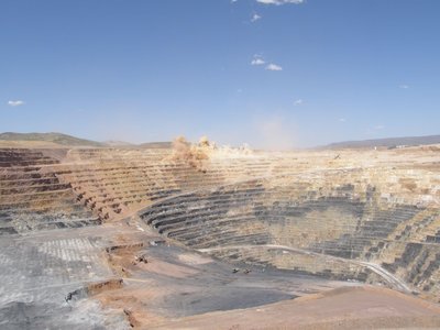
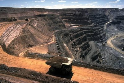
Surface mining is an important economic activity in many regions where mineral resources are located close to the surface. The process of ore extraction is characterised by high pit walls with steep slopes. The mining process introduces significant stress and strain changes that could lead to movement on the slope face. Slope failure on the pit walls can occur without warning and can lead to loss of life and disruptions to the mining process. The monitoring of slopes remains the most reliable way to detect movement on unstable slopes. Therefore, slope monitoring programmes have been established to monitor and measure slope movement to help mine management with the stability status of open pit slopes. Conventional monitoring techniques include visual inspections and in situ instrumentation that are point-based, time-consuming, and costly. Open-source remote sensing techniques such as Synthetic Aperture Radar interferometry have been used to monitor slope movements on open-pit mine walls. Time series interferometric Synthetic Aperture Radar (InSAR) can be used to overcome limitations of in-situ monitoring for monitoring slope movements in open-pit mines.
Related Topics


- Type
- article
- Language
- en
- Landing Page
- https://doi.org/10.5194/isprs-archives-xlviii-1-w2-2023-945-2023
- https://isprs-archives.copernicus.org/articles/XLVIII-1-W2-2023/945/2023/isprs-archives-XLVIII-1-W2-2023-945-2023.pdf
- OA Status
- diamond
- Cited By
- 2
- References
- 21
- Related Works
- 10
- OpenAlex ID
- https://openalex.org/W4389738938
Raw OpenAlex JSON
- OpenAlex ID
-
https://openalex.org/W4389738938Canonical identifier for this work in OpenAlex
- DOI
-
https://doi.org/10.5194/isprs-archives-xlviii-1-w2-2023-945-2023Digital Object Identifier
- Title
-
TIME SERIES INSAR ANALYSIS FOR SLOPE STABILITY MONITORING USING SENTINEL-1 IN OPEN PIT MININGWork title
- Type
-
articleOpenAlex work type
- Language
-
enPrimary language
- Publication year
-
2023Year of publication
- Publication date
-
2023-12-13Full publication date if available
- Authors
-
Sue Ellen Haupt, B. Sibolla, L. W. MdakaneList of authors in order
- Landing page
-
https://doi.org/10.5194/isprs-archives-xlviii-1-w2-2023-945-2023Publisher landing page
- PDF URL
-
https://isprs-archives.copernicus.org/articles/XLVIII-1-W2-2023/945/2023/isprs-archives-XLVIII-1-W2-2023-945-2023.pdfDirect link to full text PDF
- Open access
-
YesWhether a free full text is available
- OA status
-
diamondOpen access status per OpenAlex
- OA URL
-
https://isprs-archives.copernicus.org/articles/XLVIII-1-W2-2023/945/2023/isprs-archives-XLVIII-1-W2-2023-945-2023.pdfDirect OA link when available
- Concepts
-
Interferometric synthetic aperture radar, Open-pit mining, Slope stability, Geology, Synthetic aperture radar, Remote sensing, Radar, Mining engineering, Surface mining, Geotechnical engineering, Engineering, Coal mining, Telecommunications, Coal, Waste managementTop concepts (fields/topics) attached by OpenAlex
- Cited by
-
2Total citation count in OpenAlex
- Citations by year (recent)
-
2025: 1, 2024: 1Per-year citation counts (last 5 years)
- References (count)
-
21Number of works referenced by this work
- Related works (count)
-
10Other works algorithmically related by OpenAlex
Full payload
| id | https://openalex.org/W4389738938 |
|---|---|
| doi | https://doi.org/10.5194/isprs-archives-xlviii-1-w2-2023-945-2023 |
| ids.doi | https://doi.org/10.5194/isprs-archives-xlviii-1-w2-2023-945-2023 |
| ids.openalex | https://openalex.org/W4389738938 |
| fwci | 1.15172607 |
| type | article |
| title | TIME SERIES INSAR ANALYSIS FOR SLOPE STABILITY MONITORING USING SENTINEL-1 IN OPEN PIT MINING |
| biblio.issue | |
| biblio.volume | XLVIII-1/W2-2023 |
| biblio.last_page | 951 |
| biblio.first_page | 945 |
| topics[0].id | https://openalex.org/T10535 |
| topics[0].field.id | https://openalex.org/fields/23 |
| topics[0].field.display_name | Environmental Science |
| topics[0].score | 0.9959999918937683 |
| topics[0].domain.id | https://openalex.org/domains/3 |
| topics[0].domain.display_name | Physical Sciences |
| topics[0].subfield.id | https://openalex.org/subfields/2308 |
| topics[0].subfield.display_name | Management, Monitoring, Policy and Law |
| topics[0].display_name | Landslides and related hazards |
| topics[1].id | https://openalex.org/T10801 |
| topics[1].field.id | https://openalex.org/fields/22 |
| topics[1].field.display_name | Engineering |
| topics[1].score | 0.989799976348877 |
| topics[1].domain.id | https://openalex.org/domains/3 |
| topics[1].domain.display_name | Physical Sciences |
| topics[1].subfield.id | https://openalex.org/subfields/2202 |
| topics[1].subfield.display_name | Aerospace Engineering |
| topics[1].display_name | Synthetic Aperture Radar (SAR) Applications and Techniques |
| topics[2].id | https://openalex.org/T10161 |
| topics[2].field.id | https://openalex.org/fields/22 |
| topics[2].field.display_name | Engineering |
| topics[2].score | 0.9718999862670898 |
| topics[2].domain.id | https://openalex.org/domains/3 |
| topics[2].domain.display_name | Physical Sciences |
| topics[2].subfield.id | https://openalex.org/subfields/2211 |
| topics[2].subfield.display_name | Mechanics of Materials |
| topics[2].display_name | Rock Mechanics and Modeling |
| is_xpac | False |
| apc_list | |
| apc_paid | |
| concepts[0].id | https://openalex.org/C22286887 |
| concepts[0].level | 3 |
| concepts[0].score | 0.6963992714881897 |
| concepts[0].wikidata | https://www.wikidata.org/wiki/Q1666056 |
| concepts[0].display_name | Interferometric synthetic aperture radar |
| concepts[1].id | https://openalex.org/C184977646 |
| concepts[1].level | 2 |
| concepts[1].score | 0.6623459458351135 |
| concepts[1].wikidata | https://www.wikidata.org/wiki/Q15104297 |
| concepts[1].display_name | Open-pit mining |
| concepts[2].id | https://openalex.org/C110069353 |
| concepts[2].level | 2 |
| concepts[2].score | 0.5736905336380005 |
| concepts[2].wikidata | https://www.wikidata.org/wiki/Q961278 |
| concepts[2].display_name | Slope stability |
| concepts[3].id | https://openalex.org/C127313418 |
| concepts[3].level | 0 |
| concepts[3].score | 0.5351033806800842 |
| concepts[3].wikidata | https://www.wikidata.org/wiki/Q1069 |
| concepts[3].display_name | Geology |
| concepts[4].id | https://openalex.org/C87360688 |
| concepts[4].level | 2 |
| concepts[4].score | 0.499192476272583 |
| concepts[4].wikidata | https://www.wikidata.org/wiki/Q740686 |
| concepts[4].display_name | Synthetic aperture radar |
| concepts[5].id | https://openalex.org/C62649853 |
| concepts[5].level | 1 |
| concepts[5].score | 0.48939576745033264 |
| concepts[5].wikidata | https://www.wikidata.org/wiki/Q199687 |
| concepts[5].display_name | Remote sensing |
| concepts[6].id | https://openalex.org/C554190296 |
| concepts[6].level | 2 |
| concepts[6].score | 0.48119407892227173 |
| concepts[6].wikidata | https://www.wikidata.org/wiki/Q47528 |
| concepts[6].display_name | Radar |
| concepts[7].id | https://openalex.org/C16674752 |
| concepts[7].level | 1 |
| concepts[7].score | 0.4658110439777374 |
| concepts[7].wikidata | https://www.wikidata.org/wiki/Q1370637 |
| concepts[7].display_name | Mining engineering |
| concepts[8].id | https://openalex.org/C516820309 |
| concepts[8].level | 4 |
| concepts[8].score | 0.4369282126426697 |
| concepts[8].wikidata | https://www.wikidata.org/wiki/Q756944 |
| concepts[8].display_name | Surface mining |
| concepts[9].id | https://openalex.org/C187320778 |
| concepts[9].level | 1 |
| concepts[9].score | 0.3948932886123657 |
| concepts[9].wikidata | https://www.wikidata.org/wiki/Q1349130 |
| concepts[9].display_name | Geotechnical engineering |
| concepts[10].id | https://openalex.org/C127413603 |
| concepts[10].level | 0 |
| concepts[10].score | 0.22286048531532288 |
| concepts[10].wikidata | https://www.wikidata.org/wiki/Q11023 |
| concepts[10].display_name | Engineering |
| concepts[11].id | https://openalex.org/C108615695 |
| concepts[11].level | 3 |
| concepts[11].score | 0.07540041208267212 |
| concepts[11].wikidata | https://www.wikidata.org/wiki/Q12880211 |
| concepts[11].display_name | Coal mining |
| concepts[12].id | https://openalex.org/C76155785 |
| concepts[12].level | 1 |
| concepts[12].score | 0.0 |
| concepts[12].wikidata | https://www.wikidata.org/wiki/Q418 |
| concepts[12].display_name | Telecommunications |
| concepts[13].id | https://openalex.org/C518851703 |
| concepts[13].level | 2 |
| concepts[13].score | 0.0 |
| concepts[13].wikidata | https://www.wikidata.org/wiki/Q24489 |
| concepts[13].display_name | Coal |
| concepts[14].id | https://openalex.org/C548081761 |
| concepts[14].level | 1 |
| concepts[14].score | 0.0 |
| concepts[14].wikidata | https://www.wikidata.org/wiki/Q180388 |
| concepts[14].display_name | Waste management |
| keywords[0].id | https://openalex.org/keywords/interferometric-synthetic-aperture-radar |
| keywords[0].score | 0.6963992714881897 |
| keywords[0].display_name | Interferometric synthetic aperture radar |
| keywords[1].id | https://openalex.org/keywords/open-pit-mining |
| keywords[1].score | 0.6623459458351135 |
| keywords[1].display_name | Open-pit mining |
| keywords[2].id | https://openalex.org/keywords/slope-stability |
| keywords[2].score | 0.5736905336380005 |
| keywords[2].display_name | Slope stability |
| keywords[3].id | https://openalex.org/keywords/geology |
| keywords[3].score | 0.5351033806800842 |
| keywords[3].display_name | Geology |
| keywords[4].id | https://openalex.org/keywords/synthetic-aperture-radar |
| keywords[4].score | 0.499192476272583 |
| keywords[4].display_name | Synthetic aperture radar |
| keywords[5].id | https://openalex.org/keywords/remote-sensing |
| keywords[5].score | 0.48939576745033264 |
| keywords[5].display_name | Remote sensing |
| keywords[6].id | https://openalex.org/keywords/radar |
| keywords[6].score | 0.48119407892227173 |
| keywords[6].display_name | Radar |
| keywords[7].id | https://openalex.org/keywords/mining-engineering |
| keywords[7].score | 0.4658110439777374 |
| keywords[7].display_name | Mining engineering |
| keywords[8].id | https://openalex.org/keywords/surface-mining |
| keywords[8].score | 0.4369282126426697 |
| keywords[8].display_name | Surface mining |
| keywords[9].id | https://openalex.org/keywords/geotechnical-engineering |
| keywords[9].score | 0.3948932886123657 |
| keywords[9].display_name | Geotechnical engineering |
| keywords[10].id | https://openalex.org/keywords/engineering |
| keywords[10].score | 0.22286048531532288 |
| keywords[10].display_name | Engineering |
| keywords[11].id | https://openalex.org/keywords/coal-mining |
| keywords[11].score | 0.07540041208267212 |
| keywords[11].display_name | Coal mining |
| language | en |
| locations[0].id | doi:10.5194/isprs-archives-xlviii-1-w2-2023-945-2023 |
| locations[0].is_oa | True |
| locations[0].source.id | https://openalex.org/S2737215817 |
| locations[0].source.issn | 1682-1750, 1682-1777, 2194-9034 |
| locations[0].source.type | journal |
| locations[0].source.is_oa | True |
| locations[0].source.issn_l | 1682-1750 |
| locations[0].source.is_core | True |
| locations[0].source.is_in_doaj | True |
| locations[0].source.display_name | The international archives of the photogrammetry, remote sensing and spatial information sciences/International archives of the photogrammetry, remote sensing and spatial information sciences |
| locations[0].source.host_organization | https://openalex.org/P4310313756 |
| locations[0].source.host_organization_name | Copernicus Publications |
| locations[0].source.host_organization_lineage | https://openalex.org/P4310313756 |
| locations[0].source.host_organization_lineage_names | Copernicus Publications |
| locations[0].license | cc-by |
| locations[0].pdf_url | https://isprs-archives.copernicus.org/articles/XLVIII-1-W2-2023/945/2023/isprs-archives-XLVIII-1-W2-2023-945-2023.pdf |
| locations[0].version | publishedVersion |
| locations[0].raw_type | journal-article |
| locations[0].license_id | https://openalex.org/licenses/cc-by |
| locations[0].is_accepted | True |
| locations[0].is_published | True |
| locations[0].raw_source_name | The International Archives of the Photogrammetry, Remote Sensing and Spatial Information Sciences |
| locations[0].landing_page_url | https://doi.org/10.5194/isprs-archives-xlviii-1-w2-2023-945-2023 |
| locations[1].id | pmh:oai:doaj.org/article:960dee72224c4ab8bd84848f8e384789 |
| locations[1].is_oa | False |
| locations[1].source.id | https://openalex.org/S4306401280 |
| locations[1].source.issn | |
| locations[1].source.type | repository |
| locations[1].source.is_oa | False |
| locations[1].source.issn_l | |
| locations[1].source.is_core | False |
| locations[1].source.is_in_doaj | False |
| locations[1].source.display_name | DOAJ (DOAJ: Directory of Open Access Journals) |
| locations[1].source.host_organization | |
| locations[1].source.host_organization_name | |
| locations[1].license | |
| locations[1].pdf_url | |
| locations[1].version | submittedVersion |
| locations[1].raw_type | article |
| locations[1].license_id | |
| locations[1].is_accepted | False |
| locations[1].is_published | False |
| locations[1].raw_source_name | The International Archives of the Photogrammetry, Remote Sensing and Spatial Information Sciences, Vol XLVIII-1-W2-2023, Pp 945-951 (2023) |
| locations[1].landing_page_url | https://doaj.org/article/960dee72224c4ab8bd84848f8e384789 |
| indexed_in | crossref, doaj |
| authorships[0].author.id | https://openalex.org/A5075139751 |
| authorships[0].author.orcid | https://orcid.org/0000-0003-1142-7184 |
| authorships[0].author.display_name | Sue Ellen Haupt |
| authorships[0].countries | ZA |
| authorships[0].affiliations[0].institution_ids | https://openalex.org/I21360634 |
| authorships[0].affiliations[0].raw_affiliation_string | Council for Scientific and Industrial Research, NextGen Enterprises and Institutions, e-Government, Spatial Information Systems Group, Pretoria, South Africa |
| authorships[0].affiliations[1].institution_ids | https://openalex.org/I26092322 |
| authorships[0].affiliations[1].raw_affiliation_string | Department of Geography and Environmental Studies, Stellenbosch University, Stellenbosch 7955, South Africa |
| authorships[0].institutions[0].id | https://openalex.org/I21360634 |
| authorships[0].institutions[0].ror | https://ror.org/05j00sr48 |
| authorships[0].institutions[0].type | government |
| authorships[0].institutions[0].lineage | https://openalex.org/I21360634 |
| authorships[0].institutions[0].country_code | ZA |
| authorships[0].institutions[0].display_name | Council for Scientific and Industrial Research |
| authorships[0].institutions[1].id | https://openalex.org/I26092322 |
| authorships[0].institutions[1].ror | https://ror.org/05bk57929 |
| authorships[0].institutions[1].type | education |
| authorships[0].institutions[1].lineage | https://openalex.org/I26092322 |
| authorships[0].institutions[1].country_code | ZA |
| authorships[0].institutions[1].display_name | Stellenbosch University |
| authorships[0].author_position | first |
| authorships[0].raw_author_name | S. Haupt |
| authorships[0].is_corresponding | False |
| authorships[0].raw_affiliation_strings | Council for Scientific and Industrial Research, NextGen Enterprises and Institutions, e-Government, Spatial Information Systems Group, Pretoria, South Africa, Department of Geography and Environmental Studies, Stellenbosch University, Stellenbosch 7955, South Africa |
| authorships[1].author.id | https://openalex.org/A5006917173 |
| authorships[1].author.orcid | |
| authorships[1].author.display_name | B. Sibolla |
| authorships[1].countries | ZA |
| authorships[1].affiliations[0].institution_ids | https://openalex.org/I21360634 |
| authorships[1].affiliations[0].raw_affiliation_string | Council for Scientific and Industrial Research, NextGen Enterprises and Institutions, e-Government, Spatial Information Systems Group, Pretoria, South Africa |
| authorships[1].institutions[0].id | https://openalex.org/I21360634 |
| authorships[1].institutions[0].ror | https://ror.org/05j00sr48 |
| authorships[1].institutions[0].type | government |
| authorships[1].institutions[0].lineage | https://openalex.org/I21360634 |
| authorships[1].institutions[0].country_code | ZA |
| authorships[1].institutions[0].display_name | Council for Scientific and Industrial Research |
| authorships[1].author_position | middle |
| authorships[1].raw_author_name | B. Sibolla |
| authorships[1].is_corresponding | False |
| authorships[1].raw_affiliation_strings | Council for Scientific and Industrial Research, NextGen Enterprises and Institutions, e-Government, Spatial Information Systems Group, Pretoria, South Africa |
| authorships[2].author.id | https://openalex.org/A5052530563 |
| authorships[2].author.orcid | https://orcid.org/0000-0001-8541-8243 |
| authorships[2].author.display_name | L. W. Mdakane |
| authorships[2].countries | ZA |
| authorships[2].affiliations[0].institution_ids | https://openalex.org/I21360634 |
| authorships[2].affiliations[0].raw_affiliation_string | Council for Scientific and Industrial Research, NextGen Enterprises and Institutions, e-Government, Spatial Information Systems Group, Pretoria, South Africa |
| authorships[2].institutions[0].id | https://openalex.org/I21360634 |
| authorships[2].institutions[0].ror | https://ror.org/05j00sr48 |
| authorships[2].institutions[0].type | government |
| authorships[2].institutions[0].lineage | https://openalex.org/I21360634 |
| authorships[2].institutions[0].country_code | ZA |
| authorships[2].institutions[0].display_name | Council for Scientific and Industrial Research |
| authorships[2].author_position | last |
| authorships[2].raw_author_name | L. W. Mdakane |
| authorships[2].is_corresponding | False |
| authorships[2].raw_affiliation_strings | Council for Scientific and Industrial Research, NextGen Enterprises and Institutions, e-Government, Spatial Information Systems Group, Pretoria, South Africa |
| has_content.pdf | True |
| has_content.grobid_xml | True |
| is_paratext | False |
| open_access.is_oa | True |
| open_access.oa_url | https://isprs-archives.copernicus.org/articles/XLVIII-1-W2-2023/945/2023/isprs-archives-XLVIII-1-W2-2023-945-2023.pdf |
| open_access.oa_status | diamond |
| open_access.any_repository_has_fulltext | False |
| created_date | 2025-10-10T00:00:00 |
| display_name | TIME SERIES INSAR ANALYSIS FOR SLOPE STABILITY MONITORING USING SENTINEL-1 IN OPEN PIT MINING |
| has_fulltext | True |
| is_retracted | False |
| updated_date | 2025-11-06T03:46:38.306776 |
| primary_topic.id | https://openalex.org/T10535 |
| primary_topic.field.id | https://openalex.org/fields/23 |
| primary_topic.field.display_name | Environmental Science |
| primary_topic.score | 0.9959999918937683 |
| primary_topic.domain.id | https://openalex.org/domains/3 |
| primary_topic.domain.display_name | Physical Sciences |
| primary_topic.subfield.id | https://openalex.org/subfields/2308 |
| primary_topic.subfield.display_name | Management, Monitoring, Policy and Law |
| primary_topic.display_name | Landslides and related hazards |
| related_works | https://openalex.org/W3206958763, https://openalex.org/W2159160885, https://openalex.org/W2148958581, https://openalex.org/W2910315605, https://openalex.org/W2360589636, https://openalex.org/W3131272666, https://openalex.org/W2362290675, https://openalex.org/W2394347159, https://openalex.org/W2375855722, https://openalex.org/W2359788351 |
| cited_by_count | 2 |
| counts_by_year[0].year | 2025 |
| counts_by_year[0].cited_by_count | 1 |
| counts_by_year[1].year | 2024 |
| counts_by_year[1].cited_by_count | 1 |
| locations_count | 2 |
| best_oa_location.id | doi:10.5194/isprs-archives-xlviii-1-w2-2023-945-2023 |
| best_oa_location.is_oa | True |
| best_oa_location.source.id | https://openalex.org/S2737215817 |
| best_oa_location.source.issn | 1682-1750, 1682-1777, 2194-9034 |
| best_oa_location.source.type | journal |
| best_oa_location.source.is_oa | True |
| best_oa_location.source.issn_l | 1682-1750 |
| best_oa_location.source.is_core | True |
| best_oa_location.source.is_in_doaj | True |
| best_oa_location.source.display_name | The international archives of the photogrammetry, remote sensing and spatial information sciences/International archives of the photogrammetry, remote sensing and spatial information sciences |
| best_oa_location.source.host_organization | https://openalex.org/P4310313756 |
| best_oa_location.source.host_organization_name | Copernicus Publications |
| best_oa_location.source.host_organization_lineage | https://openalex.org/P4310313756 |
| best_oa_location.source.host_organization_lineage_names | Copernicus Publications |
| best_oa_location.license | cc-by |
| best_oa_location.pdf_url | https://isprs-archives.copernicus.org/articles/XLVIII-1-W2-2023/945/2023/isprs-archives-XLVIII-1-W2-2023-945-2023.pdf |
| best_oa_location.version | publishedVersion |
| best_oa_location.raw_type | journal-article |
| best_oa_location.license_id | https://openalex.org/licenses/cc-by |
| best_oa_location.is_accepted | True |
| best_oa_location.is_published | True |
| best_oa_location.raw_source_name | The International Archives of the Photogrammetry, Remote Sensing and Spatial Information Sciences |
| best_oa_location.landing_page_url | https://doi.org/10.5194/isprs-archives-xlviii-1-w2-2023-945-2023 |
| primary_location.id | doi:10.5194/isprs-archives-xlviii-1-w2-2023-945-2023 |
| primary_location.is_oa | True |
| primary_location.source.id | https://openalex.org/S2737215817 |
| primary_location.source.issn | 1682-1750, 1682-1777, 2194-9034 |
| primary_location.source.type | journal |
| primary_location.source.is_oa | True |
| primary_location.source.issn_l | 1682-1750 |
| primary_location.source.is_core | True |
| primary_location.source.is_in_doaj | True |
| primary_location.source.display_name | The international archives of the photogrammetry, remote sensing and spatial information sciences/International archives of the photogrammetry, remote sensing and spatial information sciences |
| primary_location.source.host_organization | https://openalex.org/P4310313756 |
| primary_location.source.host_organization_name | Copernicus Publications |
| primary_location.source.host_organization_lineage | https://openalex.org/P4310313756 |
| primary_location.source.host_organization_lineage_names | Copernicus Publications |
| primary_location.license | cc-by |
| primary_location.pdf_url | https://isprs-archives.copernicus.org/articles/XLVIII-1-W2-2023/945/2023/isprs-archives-XLVIII-1-W2-2023-945-2023.pdf |
| primary_location.version | publishedVersion |
| primary_location.raw_type | journal-article |
| primary_location.license_id | https://openalex.org/licenses/cc-by |
| primary_location.is_accepted | True |
| primary_location.is_published | True |
| primary_location.raw_source_name | The International Archives of the Photogrammetry, Remote Sensing and Spatial Information Sciences |
| primary_location.landing_page_url | https://doi.org/10.5194/isprs-archives-xlviii-1-w2-2023-945-2023 |
| publication_date | 2023-12-13 |
| publication_year | 2023 |
| referenced_works | https://openalex.org/W2912781587, https://openalex.org/W6665784743, https://openalex.org/W2152657318, https://openalex.org/W3091159870, https://openalex.org/W3105202875, https://openalex.org/W3017438788, https://openalex.org/W2980222126, https://openalex.org/W3000672795, https://openalex.org/W6794293658, https://openalex.org/W3022099859, https://openalex.org/W3077930651, https://openalex.org/W3212156491, https://openalex.org/W2976715433, https://openalex.org/W2152189873, https://openalex.org/W3038493160, https://openalex.org/W2792414936, https://openalex.org/W3036290273, https://openalex.org/W1998850653, https://openalex.org/W2086011904, https://openalex.org/W4246577855, https://openalex.org/W2061577342 |
| referenced_works_count | 21 |
| abstract_inverted_index.an | 4 |
| abstract_inverted_index.as | 136 |
| abstract_inverted_index.be | 160 |
| abstract_inverted_index.by | 27 |
| abstract_inverted_index.in | 8, 122, 172 |
| abstract_inverted_index.is | 3, 25 |
| abstract_inverted_index.of | 22, 67, 77, 111, 165 |
| abstract_inverted_index.on | 48, 54, 87, 148 |
| abstract_inverted_index.to | 17, 46, 65, 71, 84, 97, 103, 144, 162 |
| abstract_inverted_index.The | 20, 34, 75 |
| abstract_inverted_index.and | 40, 62, 69, 99, 121, 129 |
| abstract_inverted_index.are | 14, 126 |
| abstract_inverted_index.can | 58, 63, 159 |
| abstract_inverted_index.for | 168 |
| abstract_inverted_index.ore | 23 |
| abstract_inverted_index.pit | 29, 56, 113 |
| abstract_inverted_index.the | 18, 49, 55, 72, 80, 108 |
| abstract_inverted_index.way | 83 |
| abstract_inverted_index.Time | 152 |
| abstract_inverted_index.been | 95, 142 |
| abstract_inverted_index.have | 94, 141 |
| abstract_inverted_index.help | 104 |
| abstract_inverted_index.high | 28 |
| abstract_inverted_index.lead | 45, 64 |
| abstract_inverted_index.life | 68 |
| abstract_inverted_index.loss | 66 |
| abstract_inverted_index.many | 9 |
| abstract_inverted_index.mine | 105, 150 |
| abstract_inverted_index.most | 81 |
| abstract_inverted_index.open | 112 |
| abstract_inverted_index.situ | 123 |
| abstract_inverted_index.such | 135 |
| abstract_inverted_index.that | 43, 125 |
| abstract_inverted_index.used | 143, 161 |
| abstract_inverted_index.with | 31, 107 |
| abstract_inverted_index.Radar | 139, 157 |
| abstract_inverted_index.Slope | 52 |
| abstract_inverted_index.close | 16 |
| abstract_inverted_index.could | 44 |
| abstract_inverted_index.face. | 51 |
| abstract_inverted_index.occur | 59 |
| abstract_inverted_index.slope | 50, 91, 101, 146, 170 |
| abstract_inverted_index.steep | 32 |
| abstract_inverted_index.walls | 30, 57 |
| abstract_inverted_index.where | 11 |
| abstract_inverted_index.detect | 85 |
| abstract_inverted_index.mines. | 174 |
| abstract_inverted_index.mining | 2, 35, 73 |
| abstract_inverted_index.remote | 132 |
| abstract_inverted_index.series | 153 |
| abstract_inverted_index.slopes | 78 |
| abstract_inverted_index.status | 110 |
| abstract_inverted_index.strain | 41 |
| abstract_inverted_index.stress | 39 |
| abstract_inverted_index.visual | 119 |
| abstract_inverted_index.walls. | 151 |
| abstract_inverted_index.(InSAR) | 158 |
| abstract_inverted_index.Surface | 1 |
| abstract_inverted_index.changes | 42 |
| abstract_inverted_index.costly. | 130 |
| abstract_inverted_index.failure | 53 |
| abstract_inverted_index.in-situ | 166 |
| abstract_inverted_index.include | 118 |
| abstract_inverted_index.located | 15 |
| abstract_inverted_index.measure | 100 |
| abstract_inverted_index.mineral | 12 |
| abstract_inverted_index.monitor | 98, 145 |
| abstract_inverted_index.process | 21, 36 |
| abstract_inverted_index.regions | 10 |
| abstract_inverted_index.remains | 79 |
| abstract_inverted_index.sensing | 133 |
| abstract_inverted_index.slopes. | 33, 89, 114 |
| abstract_inverted_index.warning | 61 |
| abstract_inverted_index.without | 60 |
| abstract_inverted_index.Aperture | 138, 156 |
| abstract_inverted_index.activity | 7 |
| abstract_inverted_index.economic | 6 |
| abstract_inverted_index.movement | 47, 86, 102 |
| abstract_inverted_index.open-pit | 149, 173 |
| abstract_inverted_index.overcome | 163 |
| abstract_inverted_index.process. | 74 |
| abstract_inverted_index.reliable | 82 |
| abstract_inverted_index.surface. | 19 |
| abstract_inverted_index.unstable | 88 |
| abstract_inverted_index.Abstract. | 0 |
| abstract_inverted_index.Synthetic | 137, 155 |
| abstract_inverted_index.important | 5 |
| abstract_inverted_index.movements | 147, 171 |
| abstract_inverted_index.resources | 13 |
| abstract_inverted_index.stability | 109 |
| abstract_inverted_index.Therefore, | 90 |
| abstract_inverted_index.extraction | 24 |
| abstract_inverted_index.introduces | 37 |
| abstract_inverted_index.management | 106 |
| abstract_inverted_index.monitoring | 76, 92, 116, 167, 169 |
| abstract_inverted_index.programmes | 93 |
| abstract_inverted_index.techniques | 117, 134 |
| abstract_inverted_index.Open-source | 131 |
| abstract_inverted_index.disruptions | 70 |
| abstract_inverted_index.established | 96 |
| abstract_inverted_index.inspections | 120 |
| abstract_inverted_index.limitations | 164 |
| abstract_inverted_index.significant | 38 |
| abstract_inverted_index.Conventional | 115 |
| abstract_inverted_index.point-based, | 127 |
| abstract_inverted_index.characterised | 26 |
| abstract_inverted_index.interferometry | 140 |
| abstract_inverted_index.instrumentation | 124 |
| abstract_inverted_index.interferometric | 154 |
| abstract_inverted_index.time-consuming, | 128 |
| cited_by_percentile_year.max | 95 |
| cited_by_percentile_year.min | 90 |
| countries_distinct_count | 1 |
| institutions_distinct_count | 3 |
| sustainable_development_goals[0].id | https://metadata.un.org/sdg/12 |
| sustainable_development_goals[0].score | 0.4000000059604645 |
| sustainable_development_goals[0].display_name | Responsible consumption and production |
| citation_normalized_percentile.value | 0.82888442 |
| citation_normalized_percentile.is_in_top_1_percent | False |
| citation_normalized_percentile.is_in_top_10_percent | False |