 Geospatial Metadata
Swipe Geospatial Metadata Vs...
Geospatial Metadata
Swipe Geospatial Metadata Vs...
Explanipedia Public Learning Modules Vs Mis Dis Mal Information:


Geospatial Metadata News
Loading news…
Description
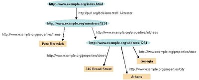
Geospatial metadata (also geographic metadata ) is a type of metadata applicable to geographic data and information. Such objects may be stored in a geographic information system (GIS) or may simply be documents, data-sets, images or other objects, services, or related items that exist in some other native environment but whose features may be appropriate to describe in a (geographic) metadata catalog (may also be known as a data directory or data inventory).
Related
More


Tags
Metadatastandards
Earthobservations
Mappingtools
Spatialtechnology
Precision
(4,097)
Accuracy
(3,496)
Data
(1,689)
Organization
(1,049)
Geography
(750)
DetailOriented
(403)
Earth
(352)
Systematic
(176)
Location
(159)
Maps
(81)
Thorough
(73)
Coordinates
(72)
Geospatialdata
(3)
Environmentalresearch
(3)
Collections
No collections available for this topic.
Details
- Slug: geospatial-metadata
- Added: Jul 20, 2024